当前位置:网站首页>Data collection solution for forestry survey and patrol inspection
Data collection solution for forestry survey and patrol inspection
2022-07-24 08:47:00 【3D GIS technology community】
| Current situation of field data acquisition :
1、 Paperwork , Field work requires a large number of paper maps , Draw the outline of Lin Ban by hand , Unable to determine the location, area and other information of the forest class ;
2、 When the field forest team collects , harsh , Operation equipment is easy to be damaged , Affect the work process ;
3、 The relative position of the image cannot be accurately located , Unable to ensure that you have reached the job location ;
4、 The accuracy of field data collection is poor , Data quality cannot be guaranteed ;
5、 Manually fill in a large number of ground class attributes 、 Ownership and other attributes , Records are cumbersome and data is easy to lose ;
6、 Data collection results in the field need to be in the office ArcGIS And other related software , Repeat the work , laborious ;

picture source : The Internet
Forestry patrol inspection starts the intelligent upgrading mode , Such as the introduction of handheld devices -- Field spirit app( Search and download experience in major application markets ), It has greatly changed the traditional way of operation . Compared with the traditional forestry inspection, it has the following characteristics :
Intelligent : Reduce human participation , Error minimization
Efficient : Real time synchronization of information , Communicate more timely
Data based : Data visualization , Understand more comprehensively

| Introduction to function application :
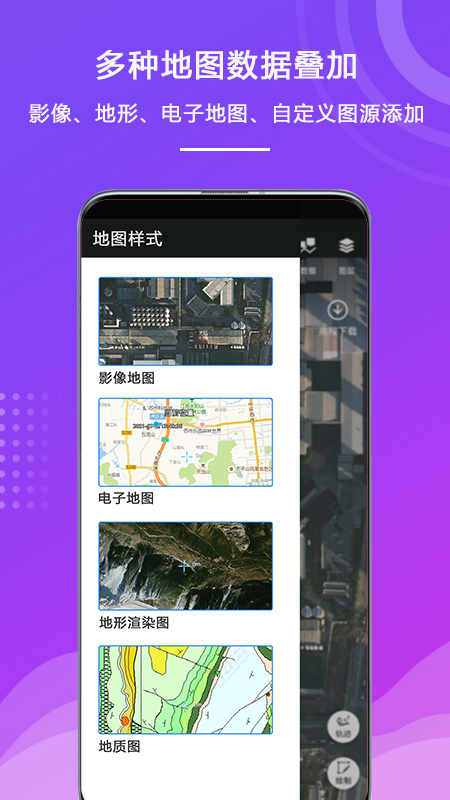
1. Map online browsing and management
Field elf integrated sky map series map , Get map data online and scan the code to add ; Control the visibility of layers 、 Editable 、 Display the properties of dimensions and the adjustment of layer order ; At the same time, it supports large vector data loading ; The image base map can be superimposed and used at any time in different data projects .
2. Map annotation and symbolization
Support rapid drawing and attribute editing of point, line and surface features , All kinds of information need to be collected anytime, anywhere , At the same time, plotting supports recording attachment information 、 Attribute table information, etc , It can help you collect data more accurately by business .

3. Access hardware equipment to achieve sub meter positioning accuracy
The software supports the actual location 、 Enter coordinates manually 、 Map points 、 Manually enter points for positioning ; Support to access Beidou probe to welcome device login CORS、APIS Equal difference type , To improve the accuracy of equipment positioning , The highest positioning accuracy can reach 20cm; Track real-time display , Track record can be output , Support time node backtracking . Differential function

4. Integration of internal and external collection
Support screen cursor 、 hand-painted 、 Manual input 、 Actually measured 、 The average value is measured by a variety of acquisition operations , Adopt a new algorithm to collect data , Improve the accuracy of data acquisition ; Support manual collection 、 Self delivery collection mode by time and distance ; Different collection items are stored independently , Classification of elements within the project 、 Sub folder management , Folders support custom collection properties , Able to adapt to various field scenes , The data collected from the field can be exported to the office software with one click -- Figure New Earth desktop Perform analytical processing .

5. Data editing module
Standard Editor : Node editing of graph 、 Graphic reproduction 、 Delete 、 revoke 、 Redo the operation ;
Senior editor : Merging of faces 、 Division 、 Wire connection 、 The boundary is connected in series ; Property update : Attribute factor entry 、 Data dictionary support .
6. Photo acquisition module
It can take multiple photos of the target object 、 Video material , And automatically associate with the target object , Record the coordinates of the photographing point .
7. External data exchange
If you need to add base map data , Allow import kml、kmz、csv、shp、Mbtiles、Lrp And other map data , Excellent map display engine makes you unobstructed in the era of big data , Any switch view ;

8. Flexible teamwork
For multi person team tasks , Provide collection content template , Achieve unified editing of data format , Team distribution , Solve the problems in team data consolidation
summary :
Move GIS Use in forestry data collection , It can improve the intelligent service level of forestry work , After fully implementing the application of various information technologies , It is helpful to promote the intelligent process of forestry data collection , Improve the working efficiency and reliability of the acquisition personnel in this work , It is a very meaningful breakthrough for forestry work , And for electricity 、 mine 、 Patrol inspection in agriculture and other industries 、 The investigation has extensive reference significance
边栏推荐
猜你喜欢
![[Shangshui Shuo series together] June summary +no anxiety +july plan + how to test + how to improve](/img/75/e8f5a1dfe7594b75b6c7facb49ccfa.png)
[Shangshui Shuo series together] June summary +no anxiety +july plan + how to test + how to improve

First acquaintance with JVM

Treap
![The solution of [an error occurred while trying to create a file in the destination directory: access denied] is prompted when installing the software](/img/e5/391cc8ffc3b0410831883be9bde320.png)
The solution of [an error occurred while trying to create a file in the destination directory: access denied] is prompted when installing the software

office回退版本,从2021到2019

The beta version of move protocol is stable, and it is temporarily decided to expand the scale of the prize pool

4、 Midway integrates swagger and supports JWT bearers

Hack the box - File Inclusion module detailed Chinese tutorial

Confusing defer, return, named return value, anonymous return value in golang

Scatter chart - date
随机推荐
Read and understand move2earn project - move
Kotlin学习笔记1——变量、函数
Oauth2 server set up oauth2 authentication service
Ansible automatic operation and maintenance
Scatter chart - date
Move protocol global health declaration, step into Web3 in sports
Dynamic programming & backtracking various deformation problems
Houdini 笔记
Is gamefi in decline or in the future?
Sed add content after a line
【FFH】OpenHarmony啃论文成长计划---cJSON在传统C/S模型下的应用
Xiaobai learns Jenkins - installation and quick start
利用opencv 做一个简单的人脸识别
Typora prompt [this beta version of typora is expired, please download and install a new version]
Wildcards in MySQL like statements: percent, underscore, and escape
超全总结:Go语言如何操作文件
[Shangshui Shuo series] final rad New Literacies
Advantages and disadvantages of redis and ZK implementing distributed locks
Optimization of MySQL paging query
First acquaintance with JVM