当前位置:网站首页>Associated GIS: all roads lead to ue5 City
Associated GIS: all roads lead to ue5 City
2022-06-27 08:03:00 【xosg】
Part1 Preface
This article describes how to use UE5 Of Georeferencing Plug-in implementation UE5 And GIS Coordinate Association .

Part2 Introduction to coordinate system
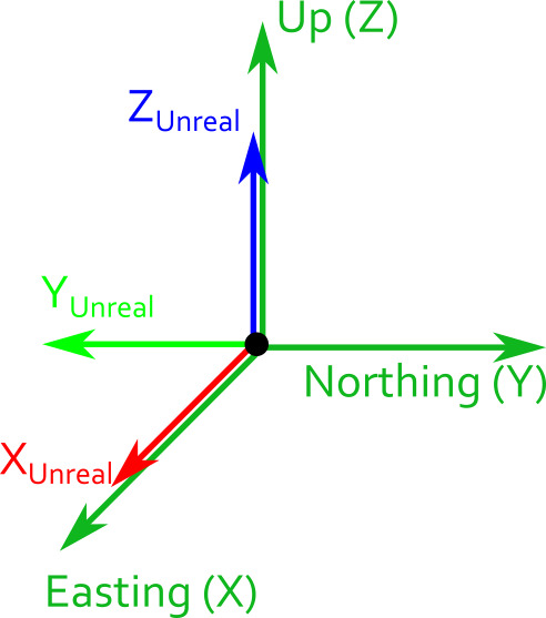
The following coordinate systems are mainly involved here , Here's the picture 
1、 Geography CRS Coordinate system
Express by latitude and longitude and altitude
latitude = Elevation distance relative to the equator , In degrees
longitude = Relative to the prime meridian ( Greenwich ) The azimuth of , In degrees
At an altitude of = Height relative to the reference ellipsoid , In meters
Angles are expressed in decimal , namely DMS( Degrees, minutes and seconds ).2、 The center of the earth CRS Coordinate system The center of the earth CRS Use Cartesian coordinates to define the position of any point on the planet , Where the origin is at the center of the planet .
origin = centrosphere X The axis points to the equator / Prime meridian ( Greenwich ) Point of intersection .Z The axis is aligned with the rotation axis of the earth .Y The axis is orthogonal to the first two axes .
3、 Northeast sky coordinate system
As shown in the above figure, the environment is a green square
It is agreed here that X Axis = Easting( In the east ) = UE Of X Axis Y Axis = Northing( north )= UE Of Y Shaft inversion Z Axis = Up( God )= UE Of Z Axis
Part3 Modeling requirements
We use it 3dmax build BIM When modeling , Need to ensure that the model needs to be guaranteed X The axis points east 、Y The axis points straight north 、Z Axis pointing to sky . After that DataSmith Import UE5, At this point, the model can be connected with GIS Coordinate correct association .
Part4 The plug-in USES
1 establish GeoReferencingSystem
Create a... At the level GeoReferencingSystem object , The path is shown in the figure below , If you can't find it , Please set up Show Engine Content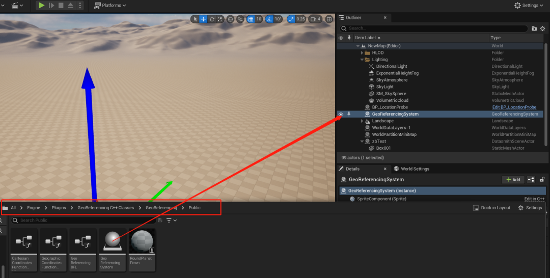
Then choose Planet Shape In the shape of an ellipsoid , namely Round Planet. The coordinate system standard can be used by default .
Next , Set the latitude and longitude and geodetic height of the modeling origin . We need to cancel the above Origin Location in Projected CRS Can be entered . We do not use the coordinates of the projection coordinate system .
2 Latitude and longitude UE coordinate
adopt GeoGraphic to Engin The longitude and latitude can be converted into UE Coordinates of . The blueprint is used as follows :

Transformation of other coordinate systems , You can refer to the following figure to realize .

3 Status bar tools
stay /GeoReferencing/UI/UMG_GeoStatusBar Example in UMG Control is added to the viewport , Will be displayed in various CRS Current view position in : Projection 、 Geography and ECEF. Add to the viewport as follows :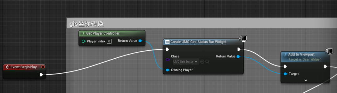 The real-time display effect is as follows :
4 Coordinate checker auxiliary control
There is a special editor helper control located in /GeoReferencing/UtilityWidgets/EUW_CoordinatesInspector in . If you run the control in the editor , It will display a panel , You can control the geographic registration coordinates of the view and the point under the mouse . We put this object in UE In the scene , You can know the coordinate information of the current scene . After running , Will show , The effect is as follows :
Part5 summary
This chapter mainly introduces how to use Georeferencing The plug-in converts the longitude and latitude to UE Step of coordinates of .
5 About IN VETA
IN VETA It's a modeling team 、 The fine arts 、UE5 A young team .

We are committed to sharing and R & D of 3D digital twin technology .
Welcome to discuss technical and business cooperation with friends from all walks of life , Together to promote the development of digital twins .
边栏推荐
- Speech signal processing - concept (II): amplitude spectrum (STFT spectrum), Mel spectrum [the deep learning of speech mainly uses amplitude spectrum and Mel spectrum] [extracted with librosa or torch
- [11. two dimensional difference]
- [batch dos-cmd command - summary and summary] - environment variables, path variables, search file location related instructions - set, path, where, what if there are spaces in the path parameters of
- JS to determine whether the number entered by the user is a prime number (multiple methods)
- js输出形状
- 淘宝虚拟产品开店教程之作图篇
- 八大误区,逐个击破(终篇):云难以扩展、定制性差,还会让管理员失去控制权?
- Publications under nature, science and cell
- [batch dos-cmd command - summary and summary] - output / display command - echo
- JS output shape
猜你喜欢
![[10. difference]](/img/15/ffd93da75858943fe887de1718e0f6.png)
[10. difference]

2、项目使用的QT组件

2022 love analysis · panoramic report of it operation and maintenance manufacturers

lvgl 说明3关于lvgl guider的使用
js中判断成绩是否合格,范围在0-100,否则重新输入

淘宝虚拟产品开店教程之作图篇
![[batch dos-cmd command - summary and summary] - output / display command - echo](/img/44/cddad70eeb756db15c19100c25c61a.png)
[batch dos-cmd command - summary and summary] - output / display command - echo

【c ++ primer 笔记】第4章 表达式
win10-如何管理开机启动项?
2022爱分析· IT运维厂商全景报告
随机推荐
"Short video" Linxia fire rescue detachment carries out fire safety training
「短视频」临夏消防救援支队开展消防安全培训授课
JS example print the number and sum of multiples of all 7 between 1-100
JS to print prime numbers between 1-100 and calculate the total number of optimized versions
After working in a large factory for ten years with an annual salary of 400000 yuan, I was suddenly laid off. If the company wanted to abandon you, it wouldn't leave any kindness
JS print 99 multiplication table
win10-如何管理开机启动项?
js中输入三个值,并且由小到大输出
Reference | upgrade win11 mobile hotspot can not be opened or connected
Game asset reuse: a new way to find required game assets faster
L'enquête en aveugle a montré que les femmes étaient meilleures que les hommes.
ACM课程学期总结
【11. 二维差分】
Speech signal processing - concept (4): Fourier transform, short-time Fourier transform, wavelet transform
【c ++ primer 笔记】第3章 字符串、向量和数组
Helix QAC is updated to 2022.1 and will continue to provide high standard compliance coverage
JS performance reward and punishment examples
Eight misunderstandings, broken one by one (final): the cloud is difficult to expand, the customization is poor, and the administrator will lose control?
野风药业IPO被终止:曾拟募资5.4亿 实控人俞蘠曾进行P2P投资
Implementation of game hexagon map