当前位置:网站首页>Google Earth Engine(GEE)——计算ndvi的零星植被状况(墨西哥为例)
Google Earth Engine(GEE)——计算ndvi的零星植被状况(墨西哥为例)
2022-06-13 12:13:00 【华为云】
本文使用Landsat7影像来计算ndvi的零星植被状况并查看影像的温度,这里面要特别注意不同的影像集合中波段名称是不同的,所以建议要认真查看波段,这里再次列举一下本次要用到的影像波段,特别注意去云波段:
Resolution
30 meters
Bands Table
| Name | Description | Min | Max | Units | Wavelength | Scale | Offset |
|---|---|---|---|---|---|---|---|
| SR_B1 | Band 1 (blue) surface reflectance | 1 | 65455 | 0.45-0.52 μm | 0.0000275 | -0.2 | |
| SR_B2 | Band 2 (green) surface reflectance | 1 | 65455 | 0.52-0.60 μm | 0.0000275 | -0.2 | |
| SR_B3 | Band 3 (red) surface reflectance | 1 | 65455 | 0.63-0.69 μm | 0.0000275 | -0.2 | |
| SR_B4 | Band 4 (near infrared) surface reflectance | 1 | 65455 | 0.77-0.90 μm | 0.0000275 | -0.2 | |
| SR_B5 | Band 5 (shortwave infrared 1) surface reflectance | 1 | 65455 | 1.55-1.75 μm | 0.0000275 | -0.2 | |
| SR_B7 | Band 7 (shortwave infrared 2) surface reflectance | 1 | 65455 | 2.08-2.35 μm | 0.0000275 | -0.2 | |
| SR_ATMOS_OPACITY | A general interpretation of atmospheric opacity generated by LEDAPS and based on the radiance viewed over Dark Dense Vegetation (DDV) within the scene. A general interpretation of atmospheric opacity is that values (after scaling by 0.001 is applied) less than 0.1 are clear, 0.1-0.3 are average, and values greater than 0.3 indicate haze or other cloud situations. SR values from pixels with high atmospheric opacity will be less reliable, especially under high solar zenith angle conditions. The SR_ATMOS_OPACITY band is provided for advanced users and for product quality assessment and has not been validated. Most users are advised to instead use the QA_PIXEL band information for cloud discrimination. | 0 | 10000 | 0.001 | 0 | ||
| SR_CLOUD_QA | Cloud Quality Assessment | 0 | 0 | ||||
| SR_CLOUD_QA Bitmask |
| ||||||
| ST_B6 | Band 6 surface temperature. If 'PROCESSING_LEVEL' is set to 'L2SR', this band is fully masked out. | 0 | 65535 | Kelvin | 10.40-12.50 μm | 0.00341802 | 149 |
| ST_ATRAN | Atmospheric Transmittance. If 'PROCESSING_LEVEL' is set to 'L2SR', this band is fully masked out. | 0 | 10000 | 0.0001 | 0 | ||
| ST_CDIST | Pixel distance to cloud. If 'PROCESSING_LEVEL' is set to 'L2SR', this band is fully masked out. | 0 | 24000 | km | 0.01 | 0 | |
| ST_DRAD | Downwelled Radiance. If 'PROCESSING_LEVEL' is set to 'L2SR', this band is fully masked out. | 0 | 28000 | W/(m^2*sr*um)/ DN | 0.001 | 0 | |
| ST_EMIS | Emissivity estimated from ASTER GED. If 'PROCESSING_LEVEL' is set to 'L2SR', this band is fully masked out. | 0 | 10000 | 0.0001 | 0 | ||
| ST_EMSD | Emissivity standard deviation. If 'PROCESSING_LEVEL' is set to 'L2SR', this band is fully masked out. | 0 | 10000 | 0.0001 | 0 | ||
| ST_QA | Uncertainty of the Surface Temperature band. If 'PROCESSING_LEVEL' is set to 'L2SR', this band is fully masked out. | 0 | 32767 | K | 0.01 | 0 | |
| ST_TRAD | Thermal band converted to radiance. If 'PROCESSING_LEVEL' is set to 'L2SR', this band is fully masked out. | 0 | 22000 | W/(m^2*sr*um)/ DN | 0.001 | 0 | |
| ST_URAD | Upwelled Radiance. If 'PROCESSING_LEVEL' is set to 'L2SR', this band is fully masked out. | 0 | 28000 | W/(m^2*sr*um)/ DN | 0.001 | 0 | |
| QA_PIXEL | Pixel quality attributes generated from the CFMASK algorithm. | 0 | 0 | ||||
| QA_PIXEL Bitmask |
| ||||||
| QA_RADSAT | Radiometric saturation QA | 0 | 0 | ||||
| QA_RADSAT Bitmask |
| ||||||
代码:
获取的最大最小值的结果: 这里用的是.values().get(0),也就是第一个值
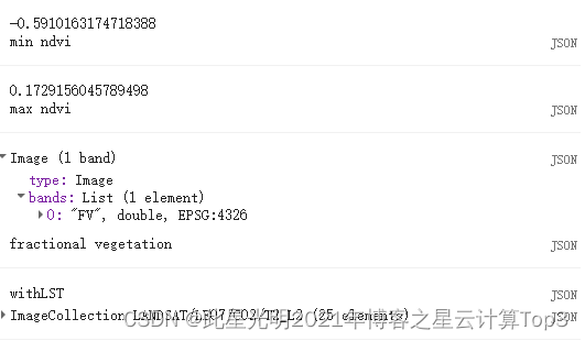
结果:


代码链接:
(179条消息) Google Earth Engine(GEE)——计算ndvi的零星植被状况(墨西哥为例)_此星光明2021年博客之星云计算Top3的博客-CSDN博客
往期推荐:
Google Earth Engine(GEE)——自动化制作30米Landsat影像和土地分类(只需要输入研究区路径)
Google Earth Engine ——Landsat 5 TM合成影像8天/32天/年际增强植被指数(EVI)数据集
Google Earth Engine ——Landsat 5 TM合成影像8天/32天/年际烧伤面积指数(BAI)
Google Earth Engine ——LANDSAT8系列归一化植被指数NDVI数据集
Google Earth Engine ——全球JRC/GSW1_3/MonthlyHistory数据集的观测数据
Google Earth Engine ——全球1984年至2015年地表水的位置和时间即地表水数据集的观测数据的元数据
边栏推荐
猜你喜欢

QT的多线程详解(包含案例)

基于STM32F103——SIM900A发送短信+串口打印

Lucene from introduction to practice
![[tcapulusdb knowledge base] Introduction to tcapulusdb tcapsvrmgr tool (III)](/img/46/e4a85bffa4b135fcd9a8923e10f69f.png)
[tcapulusdb knowledge base] Introduction to tcapulusdb tcapsvrmgr tool (III)

MCDF Experiment 2
[tcaplusdb knowledge base] Introduction to tcaplusdb tcapulogmgr tool (II)

Seccloud and trend technology jointly release the overall solution of container cloud platform and GPU resource pooling

二建资格后审没通过怎么办?这篇文章告诉你
[tcaplusdb knowledge base] Introduction to tcaplusdb tcapulogmgr tool (I)

Tamigou equity project sharing: transfer of 1637900 shares of Beijing Huadahua New Technology Co., Ltd
随机推荐
Design and implementation of database for banking system
【管理知多少】“风险登记册”本身的风险
Problems encountered in using the Pluto table of the flutter plug-in
7. Introduction to field sensing decomposing machine FFM
Pulsar 消费者
Wallys/Network_Card/DR-NAS26/AR9223/2x2 MIMO
【TcaplusDB知识库】TcaplusDB分析型文本导出介绍
Intelligent customer service system framework rasa
Branch prediction of CPU
[tcapulusdb knowledge base] Introduction to tcapulusdb table data caching
行业领先的界面组件包DevExpress 6月正式发布v21.2.8
selenium实操-自动化登录
break algorithm---dynamic planning(dp-arr)
数字化转型的深层逻辑 -企业数字化思考之二
【TcaplusDB知识库】TcaplusDB-tcapsvrmgr工具介绍(一)
2022年二建《建筑》参考答案汇总
一文说清楚SaaS(软件即服务)
002. Torchserve calls the official library model
SMS sending + serial port printing based on stm32f103-sim900a
复习指南,学生党必看