当前位置:网站首页>Google Earth engine (GEE) - real time global 10 meter land use / land cover (LULC) data set based on S2 images
Google Earth engine (GEE) - real time global 10 meter land use / land cover (LULC) data set based on S2 images
2022-06-10 15:02:00 【Hua Weiyun】
The global dynamic land classification data set is a 10 Meters of near real time (NRT) Land use / Land cover (LULC) Data sets , It includes nine categories of probability and label information .
The prediction of the dynamic world applies to 2015-06-27 So far Sentinel-2 L1C aggregate .Sentinel-2 The frequency of revisits is 2-5 God , Depending on latitude . Dynamic world prediction is aimed at CLOUDY_PIXEL_PERCENTAGE<=35% Of Sentinel-2 L1C Image generation . The prediction results are masked , To remove clouds and cloud shadows , Use S2 Cloud probability 、 The combination of cloud displacement index and direction distance transformation .
The names of the images in the dynamic world collection and the single... From which they come Sentinel-2 L1C The asset names are consistent , for example
ee.Image('COPERNICUS/S2/20160711T084022_20160711T084751_T35PKT')
There is a matching dynamic world image , be known as :ee.Image('GOOGLE/DYNAMICWORLD/V1/20160711T084022_20160711T084751_T35PKT') .
except " label " belt , The sum of all probability bands is 1.
To learn more about " Dynamic world " Data set information , And look at the resulting compounds 、 Examples of calculating regional statistics and processing time series , Please see the " Dynamic world " Introduction to the series .
Whereas " Dynamic world " The level estimation of is obtained from a single image through the spatial background of a small moving window , therefore , If there is no obvious distinguishing feature , Predicted land cover top-1 " probability " Will be relatively low , This part is defined by the cover that changes over time , Like crops . High returns in arid climates 、 sand 、 Sunlight, etc. may also show this phenomenon .
In order to select only pixels that are sure to belong to the dynamic world category , It is suggested that the former 1 An estimate of a forecast " probability " Perform threshold processing to mask the dynamic world output .
Dataset Availability
2015-06-23T00:00:00 -
Dataset Provider
Collection Snippet
ee.ImageCollection("GOOGLE/DYNAMICWORLD/V1")
Resolution
10 meters
Bands Table
| Name | Description | Min | Max |
|---|---|---|---|
| water | Estimated probability of complete coverage by water | 0 | 1 |
| trees | Estimated probability of complete coverage by trees | 0 | 1 |
| grass | Estimated probability of complete coverage by grass | 0 | 1 |
| flooded_vegetation | Estimated probability of complete coverage by flooded vegetation | 0 | 1 |
| crops | Estimated probability of complete coverage by crops | 0 | 1 |
| shrub_and_scrub | Estimated probability of complete coverage by shrub and scrub | 0 | 1 |
| built | Estimated probability of complete coverage by built | 0 | 1 |
| bare | Estimated probability of complete coverage by bare | 0 | 1 |
| snow_and_ice | Estimated probability of complete coverage by snow and ice | 0 | 1 |
| label | Index of the band with the highest estimated probability | 0 | 8 |
Class Table: label
| Value | Color | Color Value | Description |
|---|---|---|---|
| 0 | #419BDF | water | |
| 1 | #397D49 | trees | |
| 2 | #88B053 | grass | |
| 3 | #7A87C6 | flooded_vegetation | |
| 4 | #E49635 | crops | |
| 5 | #DFC35A | shrub_and_scrub | |
| 6 | #C4281B | built | |
| 7 | #A59B8F | bare | |
| 8 | #B39FE1 | snow_and_ice |
attribute :
| Name | Type | Description |
|---|---|---|
| dynamicworld_algorithm_version | String | The version string uniquely identifying the Dynamic World model and inference process used to produce the image. |
| qa_algorithm_version | String | The version string uniquely identifying the cloud masking process used to produce the image. |
Other official website links APP:
App: https://www.dynamicworld.app
Thesis link :
https://doi.org/10.1038/s41597-022-01307-4
Code :
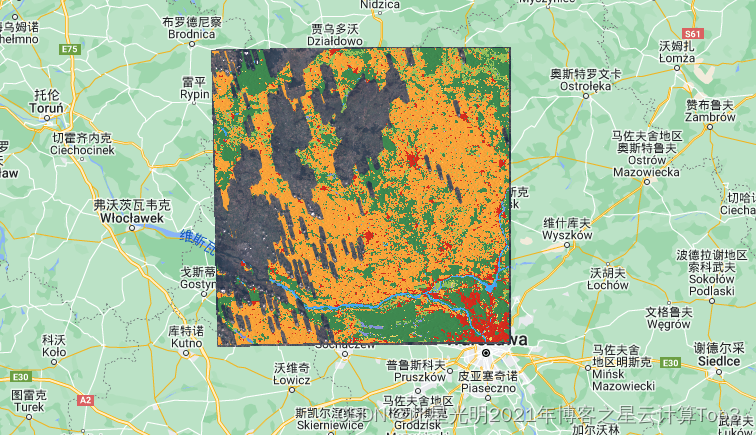
// Build a corresponding dynamic world and Sentinel-2 Set , For inspection . Filter by region and date DW and S2 Set .var COL_FILTER = ee.Filter.and( ee.Filter.bounds(ee.Geometry.Point(20.6729, 52.4305)), ee.Filter.date('2021-04-02', '2021-04-03'));// The two datasets are filtered according to the same results var dwCol = ee.ImageCollection('GOOGLE/DYNAMICWORLD/V1').filter(COL_FILTER);var s2Col = ee.ImageCollection('COPERNICUS/S2').filter(COL_FILTER);// Add the corresponding DW and S2 Images ( Through the system : Indexes ).var DwS2Col = ee.Join.saveFirst('s2_img').apply(dwCol, s2Col, ee.Filter.equals({leftField: 'system:index', rightField: 'system:index'}));// Pick up a DW Examples of images and their sources S2 Images .var dwImage = ee.Image(DwS2Col.first());var s2Image = ee.Image(dwImage.get('s2_img'));// Create a will DW Class label and probability fusion visualization . Definition DW LULC A list of labels and colors .var CLASS_NAMES = [ 'water', 'trees', 'grass', 'flooded_vegetation', 'crops', 'shrub_and_scrub', 'built', 'bare', 'snow_and_ice'];var VIS_PALETTE = [ '419BDF', '397D49', '88B053', '7A87C6', 'E49635', 'DFC35A', 'C4281B', 'A59B8F', 'B39FE1'];// stay [0, 1] Create a label on ( Most likely category ) Of RGB Images .var dwRgb = dwImage .select('label') .visualize({min: 0, max: 8, palette: VIS_PALETTE}) .divide(255);// Get the most likely classification probability .var top1Prob = dwImage.select(CLASS_NAMES).reduce(ee.Reducer.max());// stay [0, 1] Create a mountain chart of the most likely category probability on .var top1ProbHillshade = ee.Terrain.hillshade(top1Prob.multiply(100)) .divide(255);// take RGB The image is combined with the hilly area .var dwRgbHillshade = dwRgb.multiply(top1ProbHillshade);// Use source Sentinel-2 Images show the visualization of the dynamic world .Map.setCenter(20.6729, 52.4305, 12);Map.addLayer( s2Image, {min: 0, max: 3000, bands: ['B4', 'B3', 'B2']}, 'Sentinel-2 L1C');Map.addLayer( dwRgbHillshade, {min: 0, max: 0.65}, 'Dynamic World');Land classification results
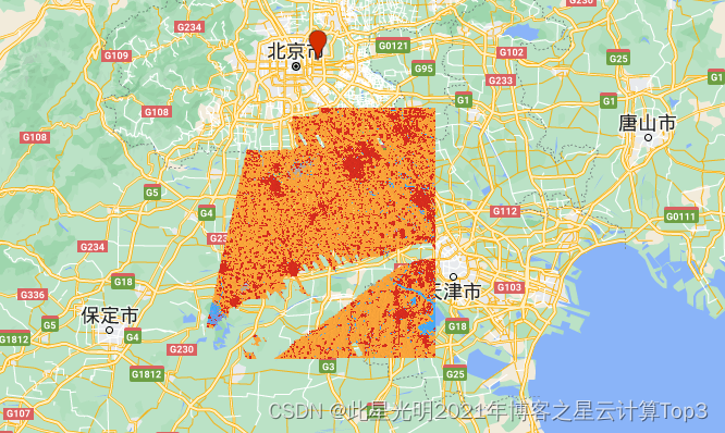
Beijing area :
![]()
Previous recommendation :
GEE-2015-2019 year 100 Dynamic land cover data set with meter resolution (CGLS-LC100)
Google Earth Engine(GEE)——GEDI L4B Global surface biomass density 1000m Resolution data set
边栏推荐
- My first go program
- Notes on the second test of C language
- 二分查找详解
- LeetCode_ 20 (brackets match)
- Scrollview is not at the top during initialization?
- 2022 the 15th Nanjing International Industrial Automation Exhibition
- 2022第十四届南京国际人工智能产品展会
- In what scenario can we not use the arrow function?
- This article introduces you to j.u.c's futuretask, fork/join framework and BlockingQueue
- 2022第十五届南京国际数字化工业博览会
猜你喜欢

In what scenario can we not use the arrow function?

Gin blog summary 1

作为程序员,对于底层原理真的有那么重要吗?

Hutool使用总结(VIP典藏版)

AUTOCAD——设置文字间距与行距

2022第十四届南京国际人工智能产品展会

Day10/11 recursion / backtracking

超强实操!手把手教学Kinect深度图与RGB摄像头的标定与配准
![[logodetection data set processing] (1) divide the data set into training set and verification set](/img/f9/422cd4b710cd57f0ebb3abd7e01c29.png)
[logodetection data set processing] (1) divide the data set into training set and verification set

JMeter 中如何实现接口之间的关联?
随机推荐
Docker deploys a redis cluster
LeetCode_ 20 (brackets match)
Cmake actual combat record (I)
小程序实现全局数据共享
微信小程序 颜色渐变
2022第十四届南京国际人工智能产品展会
2022 the 14th Nanjing International artificial intelligence product exhibition
Flyter page Jump to transfer parameters, tabbar learning summary 5
Usage Summary of call () method and apply () method in JS
How can JMeter parameterization be implemented?
2022 Nanjing International Smart site equipment exhibition
微信小程序 日期比较,计算天数
2022第十四届南京国际人工智能产品展会
Cell asynchronously invokes method change records
Insight technology was selected into the "Aijian · privacy computing manufacturer panorama report" and was rated as a representative manufacturer of financial solutions
This awesome low code generator is now open source!
产品开发的早期阶段,是选择开发app还是小程序?
远程监控及数据采集解决方案
Problems with database creation triggers
JS get the maximum value in the array