QLUSTER is a relative orbit design tool for formation flying satellite missions and space rendezvous scenarios

Related tags

GeolocationQLUSTER
Overview

https://raw.githubusercontent.com/sammmlow/QLUSTER/main/gui/qluster_logo.png

Project: QLUSTER
Github: https://github.com/sammmlow/QLUSTER
Documents: https://example.com/
Version: 0.1 (Unstable)

docs license

Author: Samuel Y. W. Low

linkedin orcid

QLUSTER

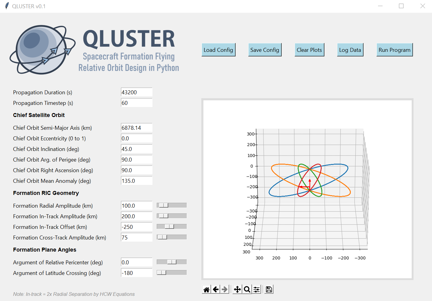
QLUSTER is a relative orbit design tool for formation flying satellite missions and space rendezvous scenarios, that I wrote in Python 3 for my own research and visualisation. It is currently unfinished (95%) but the core algorithm and app works. Here's an example snippet of the GUI where four deputy satellites are orbiting a single chief in LEO.

https://raw.githubusercontent.com/sammmlow/QLUSTER/main/gui/qluster_gui.png

I am open-sourcing it, as I would love to collaborate with you to improve on QLUSTER if you have any cool features to add-on in relation to the design, visualisation, and propagation of the relative astrodynamics!

To-Do List: Documentation, deputy orbit determination, logging of ephemeris etc.

Stretch-Goals: Relative orbit propagation for perturbed orbits, and computation of formation maintenance.


Installation and First Steps

First, clone this repository by running in your terminal (or Git Bash):

git clone https://github.com/sammmlow/QLUSTER.git

Then, just run the main qluster.py file in the main directory, and the GUI should pop up. Have fun!


Other Package Dependencies

To be written


Contact

If you have any queries feel free to reach out to me at:

[email protected]

linkedin orcid

Last Modified on 30-May-2021

Owner
Samuel Low
🌌 Space 🚀 Orbits 📡 Tech 🌏 Earth 🌳 Nature 🐢 Life ♥️
Samuel Low
Python bindings and utilities for GeoJSON

geojson This Python library contains: Functions for encoding and decoding GeoJSON formatted data Classes for all GeoJSON Objects An implementation of

Jazzband 765 Jan 06, 2023
Geocoding library for Python.

geopy geopy is a Python client for several popular geocoding web services. geopy makes it easy for Python developers to locate the coordinates of addr

geopy 3.8k Dec 30, 2022
Imperial Valley Geomorphology Map

Roughly maps the extent of basins, basin edges, and mountains in the Imperial Valley by grouping terrain classes from the Iwahashi et al. 2021 California terrian classification model.

0 Dec 13, 2022
Histogram matching plugin for rasterio

rio-hist Histogram matching plugin for rasterio. Provides a CLI and python module for adjusting colors based on histogram matching in a variety of col

Mapbox 75 Sep 23, 2022
Code and coordinates for Matt's 2021 xmas tree

xmastree2021 Code and coordinates for Matt's 2021 xmas tree This repository contains the code and coordinates used for Matt's 2021 Christmas tree, as

Stand-up Maths 117 Jan 01, 2023
Python library to decrypt Airtag reports, as well as a InfluxDB/Grafana self-hosted dashboard example

Openhaystack-python This python daemon will allow you to gather your Openhaystack-based airtag reports and display them on a Grafana dashboard. You ca

Bezmenov Denys 19 Jan 03, 2023
Python interface to PROJ (cartographic projections and coordinate transformations library)

pyproj Python interface to PROJ (cartographic projections and coordinate transformations library). Documentation Stable: http://pyproj4.github.io/pypr

832 Dec 31, 2022
Wraps GEOS geometry functions in numpy ufuncs.

PyGEOS PyGEOS is a C/Python library with vectorized geometry functions. The geometry operations are done in the open-source geometry library GEOS. PyG

362 Dec 23, 2022
The geospatial toolkit for redistricting data.

maup maup is the geospatial toolkit for redistricting data. The package streamlines the basic workflows that arise when working with blocks, precincts

Metric Geometry and Gerrymandering Group 60 Dec 05, 2022
QLUSTER is a relative orbit design tool for formation flying satellite missions and space rendezvous scenarios

QLUSTER is a relative orbit design tool for formation flying satellite missions and space rendezvous scenarios, that I wrote in Python 3 for my own research and visualisation. It is currently unfinis

Samuel Low 9 Aug 23, 2022
A Python framework for building geospatial web-applications

Hey there, this is Greppo... A Python framework for building geospatial web-applications. Greppo is an open-source Python framework that makes it easy

Greppo 304 Dec 27, 2022
When traveling in the backcountry during winter time, updating yourself on current and recent weather data is important to understand likely avalanche danger.

Weather Data When traveling in the backcountry during winter time, updating yourself on current and recent weather data is important to understand lik

Trevor Allen 0 Jan 02, 2022
GetOSM is an OpenStreetMap tile downloader written in Python that is agnostic of GUI frameworks.

GetOSM GetOSM is an OpenStreetMap tile downloader written in Python that is agnostic of GUI frameworks. It is used with tkinter by ProjPicker. Require

Huidae Cho 3 May 20, 2022
Construct and use map tile grids in different projection.

Morecantile +-------------+-------------+ ymax | | | | x: 0 | x: 1 | | y: 0 | y: 0

Development Seed 67 Dec 23, 2022
Google maps for Jupyter notebooks

gmaps gmaps is a plugin for including interactive Google maps in the IPython Notebook. Let's plot a heatmap of taxi pickups in San Francisco: import g

Pascal Bugnion 747 Dec 19, 2022
A Django application that provides country choices for use with forms, flag icons static files, and a country field for models.

Django Countries A Django application that provides country choices for use with forms, flag icons static files, and a country field for models. Insta

Chris Beaven 1.2k Jan 03, 2023
Geographic add-ons for Django REST Framework. Maintained by the OpenWISP Project.

Geographic add-ons for Django REST Framework. Maintained by the OpenWISP Project.

OpenWISP 982 Jan 06, 2023
🌐 Local tile server for viewing geospatial raster files with ipyleaflet

🌐 Local Tile Server for Geospatial Rasters Need to visualize a rather large raster (gigabytes) you have locally? This is for you. A Flask application

Bane Sullivan 192 Jan 04, 2023
Bacon - Band-limited Coordinate Networks for Multiscale Scene Representation

BACON: Band-limited Coordinate Networks for Multiscale Scene Representation Project Page | Video | Paper Official PyTorch implementation of BACON. BAC

Stanford Computational Imaging Lab 144 Dec 29, 2022
Fiona reads and writes geographic data files

Fiona Fiona reads and writes geographic data files and thereby helps Python programmers integrate geographic information systems with other computer s

987 Jan 04, 2023