当前位置:网站首页>KingbaseES V8 GIS data migration solution (2. Introduction to the capabilities of Kingbase GIS)
KingbaseES V8 GIS data migration solution (2. Introduction to the capabilities of Kingbase GIS)
2022-08-05 01:53:00 【A thousand sails pass by the side of the sinking boat_】
2. Introduction to Kingbase GIS capabilities
2.1. Overview
New infrastructure represented by 5G, big data centers, artificial intelligence, industrial Internet, Internet of Things, etc. is becoming a new engine for my country's economic development.As an important security guarantee for the bottom layer of the new infrastructure, geographic information technology will also have great potential.With the large-scale application of GIS in various industries, GIS-related technical research, project application and market promotion emerge as the times require, such as various GIS platforms, middleware, storage, etc. At the same time, for the core spatial database of GIS, morehigh demands.
Renmin University Jincang, as the head enterprise of domestic database software, has a data management software product KingbaseES with independent intellectual property rights, which can be widely used in government informatization, enterprise informatization and personal information services, natural resources, electricity, finance, etc.field.The kingbaseES V8 (hereinafter referred to as KES) database can replace foreign database products such as Oracle, MySQL, etc., and meet the transformation and upgrading requirements of domestic databases such as management information systems, business and production systems, and decision support systems of enterprises and institutions.
2.2. Relationship between KingbaseES database management system and GIS system and data
GIS data mainly includes structured data (such as vector data), unstructured data (such as raster data) and some file type data (various tile cache data).The storage relationship of these data is shown in the following figure:

Figure 2.2.1 Database relationship
Most GIS platforms at home and abroad use the above architecture to store spatial data, and among the database types, the relational database is the most stored and most frequently used, which can store vector data, raster data, 3D data and other GISRelevant data, such as Yizhirui's GeoScene platform and SuperMap's SuperMap platform, use the structure shown in the figure above to store spatial data.
KingbaseES has KGIS plug-in (hereinafter referred to as KGIS), with spatial database capabilities.KingbaseES+KGIS is a relational database system that meets the above requirements. The following will introduce the capabilities of spatial data stored in the KES database management system:
Vector data: Vector data such as administrative divisions, buildings, POI points, roads, etc. The extensions of common vector data file formats are .dwg, .dxf, .shp, .kml, .geosjon, etc.Among them, .dwg and .dxf are the file formats of CAD, and .shp is the vector format of ESRI (now it has become an international standard).
Data storage method
The spatial database converts the vector data files into database tables for storage, and there will be special fields in the database tables to store the space for the vector filesLocation, as shown in the geom field in the following figure.

Figure 2.2.2 Database storage space data

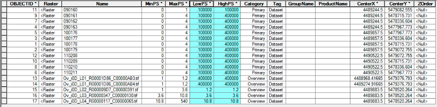
2) Raster data: KGIS has the ability to store raster data. Raster data uses pixel value information to express geography and features. There are many kinds of data, such as aerial photos, satellite photos, elevations or drones, etc.Various raster files, such as tif, img and other raster data.KGIS can directly store metadata and other attribute information of data, thereby improving data query efficiency and reducing the time and space cost of raster data storage and reading.Such as the actual storage path of the image, center point, range frame, ephemeris parameter information, etc.As shown below:
Figure 2.2.3 Raster data storage attribute table

3) 3D data: KGIS has the ability to store 3D data, supports "Z" dimension for expressing height information and "M" dimension for adding additional information, 3D and 4D data, and also supports 3D spatial data, such as TIN (Irregular Triangulation Network), POLYHEDRALSURFACE to model volume objects in the database, KGIS also has many functions that can be used to calculate the relationship between three-dimensional objects.
Note:
The 3D model and oblique photogrammetry data in the GIS system are not stored in this way. For the storage method, please refer to raster data storage.
边栏推荐
猜你喜欢
优化Feed流遭遇拦路虎,是谁帮百度打破了“内存墙”?
Understand the recommendation system in one article: Recall 06: Two-tower model - model structure, training method, the recall model is a late fusion feature, and the sorting model is an early fusion
ExcelPatternTool: Excel table-database mutual import tool
Gartner Hype Cycle:超融合技术将在2年内到达“生产力成熟期”
刷爆朋友圈,Alibaba出品亿级并发设计速成笔记太香了
【Unity入门计划】2D游戏中遮挡问题的处理方法&伪透视
多线程涉及的其它知识(死锁(等待唤醒机制),内存可见性问题以及定时器)
![[Endnote] Word inserts a custom form of Endnote document format](/img/70/e8a6f15b80e9c53db369fd715e51df.png)
[Endnote] Word inserts a custom form of Endnote document format
【Endnote】Word插入自定义形式的Endnote文献格式
KingbaseES V8 GIS数据迁移方案(2. Kingbase GIS能力介绍)
随机推荐
1349. Maximum number of students taking the exam Status Compression
迁移学习——Joint Geometrical and Statistical Alignment for Visual Domain Adaptation
"Configuration" is a double-edged sword, it will take you to understand various configuration methods
Chapter 09 Use of Performance Analysis Tools [2. Index and Tuning] [MySQL Advanced]
.Net C# 控制台 使用 Win32 API 创建一个窗口
自定义线程池
使用OpenVINO实现飞桨版PGNet推理程序
day14--postman interface test
How to create an rpm package
DDOS攻击真的是无解吗?不!
详细全面的postman接口测试实战教程
蓝牙Mesh系统开发四 ble mesh网关节点管理
Oracle encapsulates restful interfaces into views
Three handshake and four wave in tcp
fragment可见性判断
JWT简单介绍
Greenplum数据库故障分析——能对数据库base文件夹进行软连接嘛?
手把手基于YOLOv5定制实现FacePose之《YOLO结构解读、YOLO数据格式转换、YOLO过程修改》
开篇-开启全新的.NET现代应用开发体验
GCC: paths to header and library files