当前位置:网站首页>Application of point cloud intelligent drawing in intelligent construction site
Application of point cloud intelligent drawing in intelligent construction site
2022-06-25 07:39:00 【Oxygen technique】
Application of point cloud intelligent painting in intelligent construction site
The point cloud obtained by airborne lidar and image-based dense matching technology can be used to monitor the construction progress of construction site and calculate the filling and excavation , Pictured 1 Shown .

chart 1 Display of point cloud data of construction site obtained by airborne laser radar point cloud
01 Technical process
Users get multiple phases ( At least two phases ) Behind the point cloud , be based on PCA The software can process point cloud data according to the following process .
This case contains two phases of point cloud data and one shapefile Format of two site outline polygon files , Pictured 2 Shown . The point cloud data of the two phases are photogrammetric point clouds , The experimental area is located in the Hong Kong Special Administrative Region of China .

(a) Point cloud data of the previous phase

(b) Point cloud data of the latter phase 
(c) Polygonal boundary of two construction sites
chart 2 Two phase point cloud and site polygon
(1) Crop out the point cloud data of the region of interest
For two phases of point cloud data , Using the cloud pictures respectively “ cutting ” The tool obtains the point cloud data of the site area of interest .“ cutting ” In the tools , Choose to use “ Block according to the following chart ” The pattern of , Allow users to take advantage of shapefile Format polygon file to cut the original point cloud data , Pictured 3 Shown .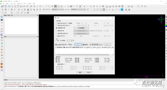
chart 3 “ cutting ” Tools
Obtain the data of the region of interest of the two phase point cloud, as shown in the figure 4 Shown .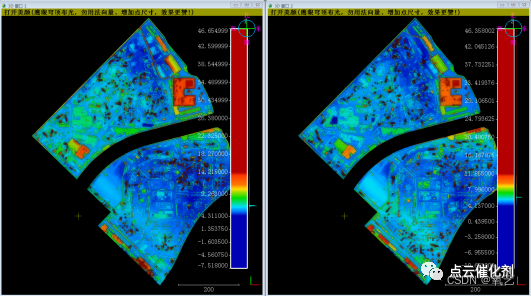
chart 4 Before the region of interest ( Left ) after ( Right ) Two phases of point cloud data , The point cloud data of each issue includes the following 、 The next two construction sites
(2) Gross error elimination ( Optional )
If there is a rough handicap in the point cloud , It is recommended to eliminate noise . The shape and spatial distribution characteristics of the noise are different , The user needs to select the appropriate noise elimination method according to the actual situation . If the user is a beginner , It is recommended that users use figure 5 in “SOR filter ”.

chart 5 Noise removal tool in cloud image
(3) Point cloud filtering ( Fine terrain extraction )
It is suggested to use Yunxiang's “ One click plain fine terrain extraction ( No reference )” Filter the point cloud data to distinguish the ground points in the point cloud 、 Non ground point .“ One click plain fine terrain extraction ( No reference )” The position of the tool is shown in the figure 6 Shown .
chart 6 “ One click plain fine terrain extraction ( No reference )” The location of the tool
The ground points obtained by filtering the point cloud data of the region of interest in the previous and subsequent phases of the two construction sites are shown in the figure 7 Shown .
chart 7 Before the region of interest ( Left ) after ( Right ) Ground points of the two phases
(4) Calculation of earthwork volume for filling and excavation
Select the point cloud data to be processed before and after a construction site , adopt “ Calculation of earthwork volume for filling and excavation ” Tool to calculate earthwork volume ,“ Calculation of earthwork volume for filling and excavation ” The tool position is shown in the figure 8 Shown .
chart 8 “ Calculation of earthwork volume for filling and excavation ” Tool location
Click on “ Calculation of earthwork volume for filling and excavation ” On the tool interface “ to update ” Button can automatically calculate the volume 、 Fill volume 、 Excavation volume , The interface is as shown in the figure 9 Shown .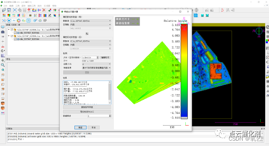
chart 9 Volume 、 Fill volume 、 Result diagram of excavation volume
The key parameters are set as shown in the figure 10 Shown . Be careful ,“ step ” The smaller it is , The more precise the volume calculation is , But not too small , Recommended setting is 0.5 Rice or so .
chart 10 Setting of key parameters
construction site 1 Volume 、 Fill volume 、 The specific contents related to statistical indicators such as excavation volume are as follows :
————————————————
Volume :-7,347.073 Cubic meters
Surface area : 156,882.500 Square meters
Fill volume :(+)16,180.567 Cubic meters
Excavation volume :(-)23,527.639 Cubic meters
———————————————
construction site 2 Volume 、 Fill volume 、 The specific contents related to statistical indicators such as excavation volume are as follows :
————————————————
Volume :-26,717.922 Cubic meters
Surface area : 151,144.750 Square meters
Fill volume :(+)7,477.177 Cubic meters
Excavation volume :(-)34,195.099 Cubic meters
—————————————————
in addition ,PCA The software also allows users to pass through “ Export grid as point cloud ” Button to export the change detection results , It is convenient for users to directly understand the general situation of the construction site , Where was the earth dug , Which places are filled with earth , Pictured 11 Shown .

chart 11 construction site 2 The change detection results show that
02 summary
Use PCA The software can process multi-phase point cloud data of the same building site , Locate the fill at the site 、 Excavation 、 Location of cut and fill , Accurately calculate mass haul volume data , And visually display the change results . in addition , The technical process of this paper can also be used for multi-stage point cloud panel coal 、 Landslide and debris flow detection 、 Earthwork calculation, etc .
边栏推荐
- 函数模板_类模板
- 国外LEAD域名邮箱获取途径
- From perceptron to transformer, a brief history of deep learning
- 【批处理DOS-CMD命令-汇总和小结】-上网和网络通信相关命令(ping、telnet、nslookup、arp、tracert、ipconfig)
- [batch dos-cmd command - summary and summary] - CMD extended command and function (CMD /e:on, CMD /e:off)
- 基于地面点稀少的LiDAR点云的茂密森林蓄积量估算
- Tempest HDMI leak receive 1
- Sichuan earth microelectronics high performance, high integration and low cost isolated 485 transceiver
- (tool class) quickly add time to code in source insight
- PI Ziheng embedded: This paper introduces the multi-channel link mode of i.mxrt timer pit and its application in coremark Test Engineering
猜你喜欢

数据可视化没有重点怎么办?
图扑软件数字孪生 3D 风电场,智慧风电之海上风电

Intel announced five new technological developments, including quantum computing, neural pseudo computing, machine programming, integrated optoelectronics, and secure computing

用太极拳讲分布式理论,真舒服!

ELK + filebeat日志解析、日志入库优化 、logstash过滤器配置属性
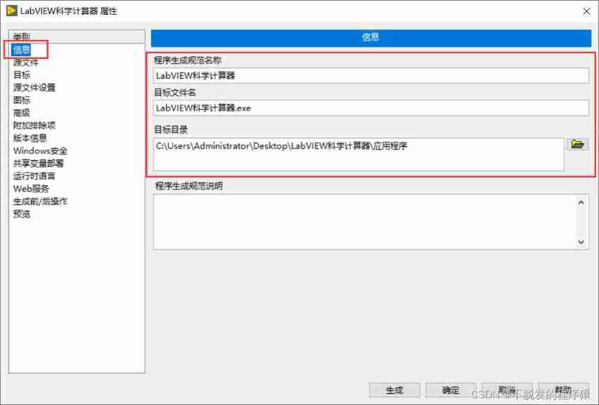
LabVIEW generate application (exe) and installer

Tempest HDMI leak receive 1

Large funds support ecological construction, and Plato farm builds a real meta universe with Dao as its governance

PI Ziheng embedded: This paper introduces the multi-channel link mode of i.mxrt timer pit and its application in coremark Test Engineering

Introduction to Sichuan Tuwei ca-is3082wx isolated rs-485/rs-422 transceiver
随机推荐
用动图讲解分布式 Raft
VectorDraw Developer Framework 10.10
TEMPEST HDMI泄漏接收 1
[Batch dos - cmd Command - Summary and Summary] - External Command - cmd Download Command, wget Command
Several good weather plug-ins
Leetcode daily question - 515 Find the maximum value in each tree row
Distributed quorum NWR of the alchemy furnace of the Supreme Master
13 `bs_duixiang.tag标签`得到一个tag对象
Ltpowercad II and ltpowerplanner III
Mysql database import SQL file display garbled code
14 BS object Node name Name attrs string get node name attribute content
关于硬件问题造成的MCU死机,过来人简单的谈一谈
Redis learning notes
Large funds support ecological construction, and Plato farm builds a real meta universe with Dao as its governance
Sichuan earth microelectronics ca-is1200 isolated operational amplifier for current detection
realsense d455 semantic_slam实现语义八叉树建图
稳压二极管的原理,它有什么作用?
Chang Wei (variables and constants) is easy to understand
Chuantuwei ca-is3720lw alternative material No. iso7820fdw
高数基础_函数的奇偶性