20 Repositories
Latest Python Libraries
EODAG is a command line tool and a plugin-oriented Python framework for searching, aggregating results and downloading remote sensed images while offering a unified API for data access regardless of the data provider
EODAG (Earth Observation Data Access Gateway) is a command line tool and a plugin-oriented Python framework for searching, aggregating results and downloading remote sensed images while offering a un

Build, deploy and extract satellite public constellations with one command line.
SatExtractor Build, deploy and extract satellite public constellations with one command line. Table of Contents About The Project Getting Started Stru

🗂️ 🔍 Geospatial Data Management and Search API - Django Apps
Geospatial Data API in Django Resonant GeoData (RGD) is a series of Django applications well suited for cataloging and searching annotated geospatial

🛰️ Scripts démontrant l'utilisation de l'imagerie RADARSAT-1 à partir d'un seau AWS | 🛰️ Scripts demonstrating the use of RADARSAT-1 imagery from an AWS bucket
🛰️ Scripts démontrant l'utilisation de l'imagerie RADARSAT-1 à partir d'un seau AWS | 🛰️ Scripts demonstrating the use of RADARSAT-1 imagery from an AWS bucket

Download and process GOES-16 and GOES-17 data from NOAA's archive on AWS using Python.
Download and display GOES-East and GOES-West data GOES-East and GOES-West satellite data are made available on Amazon Web Services through NOAA's Big
Xarray backend to Copernicus Sentinel-1 satellite data products
xarray-sentinel WARNING: this product is a "technology preview" / pre-Alpha Xarray backend to explore and load Copernicus Sentinel-1 satellite data pr

🛰️ Awesome Satellite Imagery Datasets
Awesome Satellite Imagery Datasets List of aerial and satellite imagery datasets with annotations for computer vision and deep learning. Newest datase

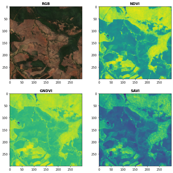
A ready-to-use curated list of Spectral Indices for Remote Sensing applications.
A ready-to-use curated list of Spectral Indices for Remote Sensing applications. GitHub: https://github.com/davemlz/awesome-ee-spectral-indices Docume

A python package that extends Google Earth Engine.
A python package that extends Google Earth Engine GitHub: https://github.com/davemlz/eemont Documentation: https://eemont.readthedocs.io/ PyPI: https:

Awesome Spectral Indices in Python.
Awesome Spectral Indices in Python: Numpy | Pandas | GeoPandas | Xarray | Earth Engine | Planetary Computer | Dask GitHub: https://github.com/davemlz/

Google Maps keeps old satellite imagery around for a while – this tool collects what's available for a user-specified region in the form of a GIF.
google-maps-at-88-mph The folks maintaining Google Maps regularly update the satellite imagery it serves its users, but outdated versions of the image

Centroid-UNet is deep neural network model to detect centroids from satellite images.
Centroid UNet - Locating Object Centroids in Aerial/Serial Images Introduction Centroid-UNet is deep neural network model to detect centroids from Aer

Generic ecosystem for feature extraction from aerial and satellite imagery
Note: Robosat is neither maintained not actively developed any longer by Mapbox. See this issue. The main developers (@daniel-j-h, @bkowshik) are no l
Satellite imagery for dummies.
felicette Satellite imagery for dummies. What can you do with this tool? TL;DR: Generate JPEG earth imagery from coordinates/location name with public

PyTorch implementation of U-TAE and PaPs for satellite image time series panoptic segmentation.
Panoptic Segmentation of Satellite Image Time Series with Convolutional Temporal Attention Networks (ICCV 2021) This repository is the official implem

A ninja python package that unifies the Google Earth Engine ecosystem.
A Python package that unifies the Google Earth Engine ecosystem. EarthEngine.jl | rgee | rgee+ | eemont GitHub: https://github.com/r-earthengine/ee_ex
Download and process satellite imagery in Python using Sentinel Hub services.
Description The sentinelhub Python package allows users to make OGC (WMS and WCS) web requests to download and process satellite images within your Py
Search and download Copernicus Sentinel satellite images
sentinelsat Sentinelsat makes searching, downloading and retrieving the metadata of Sentinel satellite images from the Copernicus Open Access Hub easy
EOReader is a multi-satellite reader allowing you to open optical and SAR data.
Remote-sensing opensource python library reading optical and SAR sensors, loading and stacking bands, clouds, DEM and index.
missing-pixel-filler is a python package that, given images that may contain missing data regions (like satellite imagery with swath gaps), returns these images with the regions filled.
Missing Pixel Filler This is the official code repository for the Missing Pixel Filler by SpaceML. missing-pixel-filler is a python package that, give