当前位置:网站首页>Simple use of leaflet - offline map scheme
Simple use of leaflet - offline map scheme
2022-06-13 02:40:00 【And white】
Go to the official website first
Show the map
 	<link rel="stylesheet" href="leaflet/leaflet.css"/>
    <script type="text/javascript" src="leaflet/leaflet-src.js"></script>
<div id="mapid"></div>
const mymap = L.map('mapid').setView([38.97649, 112.47803], 14);
L.tileLayer('https://{s}.tile.openstreetmap.org/{z}/{x}/{y}.png', {
attribution: '© <a href="https://www.openstreetmap.org/copyright">OpenStreetMap</a> contributors'
}).addTo(mymap);
Add some Line round
spot
   L.marker([37.85008, 112.4455]).addTo(mymap)
        .bindPopup(" The street ")
More than one point
L.layerGroup([marker1, marker2]).addTo(map);
If there are many points, you can use the following points to aggregate perhaps Massive point
Line
const latlngs = [
        [38.44498, 111.02783],
        [38.37612, 113.37891],
        [37.16032, 111.26953],
        [38.97649, 112.47803],
        [36.80928, 113.02734],
        [38.44498, 111.02783]
    ];
    const polyline = L.polyline(latlngs, {color: 'red'}).addTo(mymap);
    // zoom the map to the polyline
    mymap.fitBounds(polyline.getBounds());
round
    L.circle([37.89220, 112.34619], {
        radius: 135000,// Radius distance
        color: 'red',// Color
        fill: false,// Whether to fill
        interactive: false,//false  No click event will be triggered   It can only be used as the base map
    }).addTo(mymap);
Add a movement track
Add a leaflet plug-in unit leaflet.motion
leaflet.motion Address
<script type="text/javascript" src="leaflet/leaflet.motion.min.js"></script>
var latlngArr = [[34.52466, 110.23682], [35.40696, 113.51074],
       [36.41067, 113.71509], [36.70894, 113.49756]]
var carIcon = L.icon({
     iconUrl:'img/close.png',
     iconSize:[25.1,25],
 });
 L.motion.polyline(latlngArr,{
     color:'red'
 },{
     auto:true,
     duration:10000,
     easing:L.Motion.Ease.easeInOutQuart
 },{
     removeOnEnd:false,
     icon:carIcon
 }).addTo(mymap)
Point aggregation ability
With the help of point aggregation capability plug-ins
	/**
      Point aggregation capability to achieve
     head Inside   introduce js Files also have styles
     <link rel="stylesheet" href="./leaflet/dianjuhe/MarkerCluster.css"/>
     <link rel="stylesheet" href="./leaflet/dianjuhe/MarkerCluster.Default.css"/>
     <script src="./leaflet/dianjuhe/leaflet.markercluster-src.js"/>
     */
	var markers = L.markerClusterGroup({
        icon: L.icon({
            iconUrl: 'img/close.png',
            iconSize: [25.1, 25],
        }),
        // The icon displayed on the control interface
        iconCreateFunction: function(cluster) {
            if (cluster.getChildCount()>1){
                return new L.Icon({
                    iconUrl: '/img/has_point.png',
                    iconSize: [20, 20],
                })
            }else {
                return carIcon
            }
            // return L.divIcon({ html: '<b></b>' });
        }
    });
    for (var i = 0; i < Areas.length; i++) {
        var a = Areas[i];
        var title = a.name;
        var marker = L.marker(new L.LatLng(a.latitude, a.longitude), {title: title});
         //permanent  Is to permanently open tooltips , Or open only when the mouse hovers .
         marker.bindTooltip("tip-for"+i, {
             direction: "top",
             permanent: true,
             offset: L.point(0, -8)
         }).openTooltip()
        markers.addLayer(marker);
    }
    myMap.addLayer(markers);
Random hand animation points on the map 、 Line 、 polygon 、 round
Also with the help of plug-ins Geoman
	// head Introduction in
  	<script type="text/javascript" src="./leaflet-geoman.min.js"></script>
    <link rel="stylesheet" href="./leaflet-geoman.css"/>
 	// Add a menu that can draw circles, dots and polygons   And monitoring
    myMap.pm.addControls({
        position: "bottomleft",
        drawPolygon: true, //  Add draw polygon
        drawMarker: true, // Add a button to draw a marker
        drawCircleMarker: false, // Add a button to draw a circular marker
        drawPolyline: true, // Add button to draw line
        drawRectangle: true, // Add a button to draw a rectangle
        drawCircle: true, //   Add a button to draw a circle
        editMode: true, //   Add button to edit polygon
        dragMode: true, //    Add button drag polygon
        cutPolygon: true, //  Add a button to delete part of the content in the layer
        removalMode: true, //  Clear layer
    })
    myMap.on("pm:drawstart", (e) => {       // Draw start event
        console.log(e, " Start ");
    });
    myMap.on("pm:create", (e) => {
        console.log(e, " Call... When drawing is complete ");
        if (e.shape === "Rectangle") {
            alert(e.layer._latlngs[0]); // Get the coordinates of the drawing
        } else if (e.shape === "Circle") {// circular
            console.log(" The longitude and latitude of the center of the circle " + e.layer._latlng, " radius " + e.layer._mRadius)
        } else if (e.shape === "Line") {
            console.log(e.layer._latlngs)
        } else if (e.shape === "Polygon") {
            console.log(e.layer._latlngs)
        }
    });
边栏推荐
- After idea uses c3p0 connection pool to connect to SQL database, database content cannot be displayed
- Opencv 10 brightness contrast adjustment
- Chapter7-13_ Dialogue State Tracking (as Question Answering)
- Principle and steps of principal component analysis (PCA)
- 04 route jump and carry parameters
- Armv8-m learning notes - getting started
- Opencvsharp4 handwriting recognition
- Impossible d'afficher le contenu de la base de données après que l'idée a utilisé le pool de connexion c3p0 pour se connecter à la base de données SQL
- AutoX. JS invitation code
- Change tax for 2
猜你喜欢
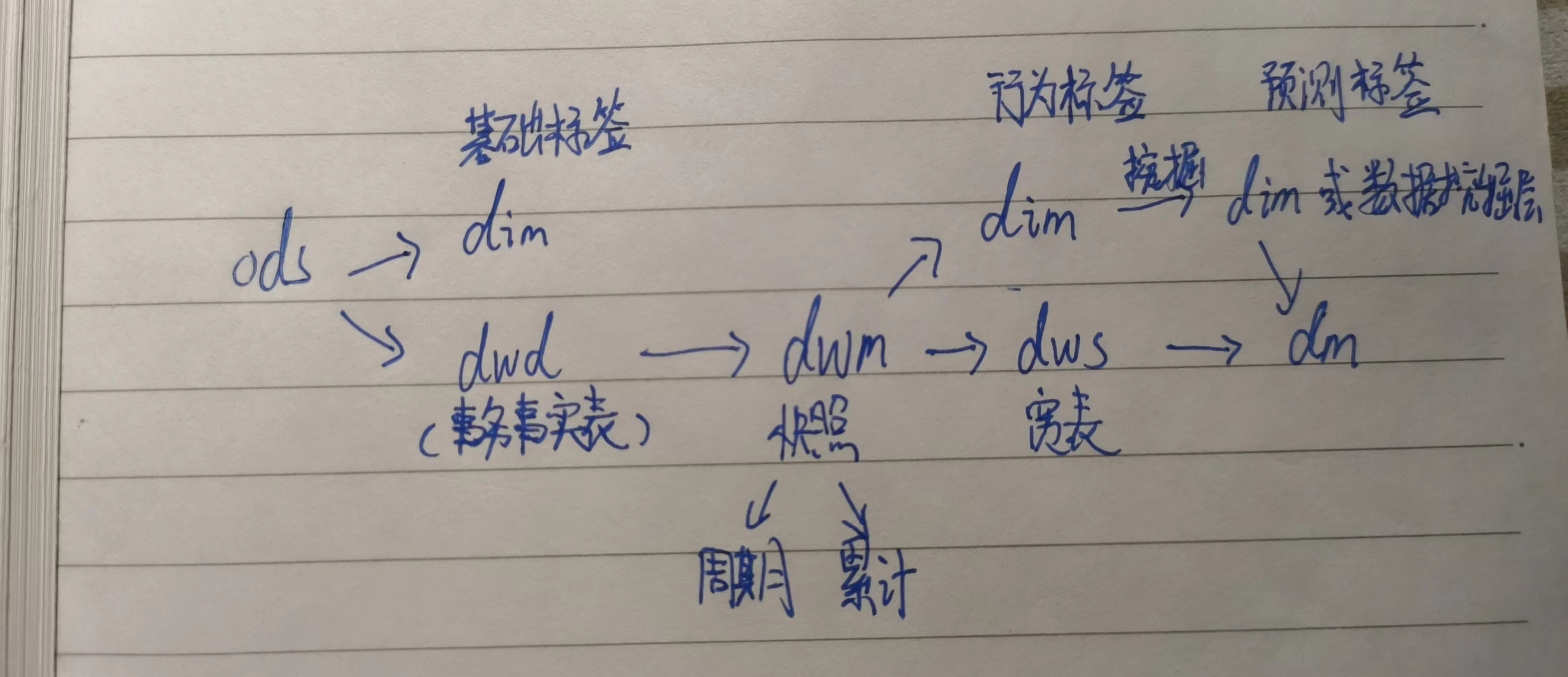
Data warehouse notes | 5 factors that need attention for customer dimension modeling
![[data analysis and visualization] key points of data drawing 4- problems of pie chart](/img/e1/618ff53b33b4b1de6acf4942130c17.jpg)
[data analysis and visualization] key points of data drawing 4- problems of pie chart
![Leetcode 926. Flip string to monotonically increasing [prefix and]](/img/ca/d23c1927bc32393cf023c748e4b449.png)
Leetcode 926. Flip string to monotonically increasing [prefix and]

在IDEA使用C3P0連接池連接SQL數據庫後卻不能顯示數據庫內容
![[data and Analysis Visualization] data operation in D3 tutorial 3-d3](/img/c9/82385b125a8e47d900c320b5f4f3b2.jpg)
[data and Analysis Visualization] data operation in D3 tutorial 3-d3

Understand speech denoising

Paper reading - jukebox: a generic model for music
在IDEA使用C3P0连接池连接SQL数据库后却不能显示数据库内容

05 tabbar navigation bar function

Chapter7-11_ Deep Learning for Question Answering (2/2)
随机推荐
Paper reading - jukebox: a generic model for music
Leetcode 926. Flip string to monotonically increasing [prefix and]
SANs证书生成
[data analysis and visualization] key points of data drawing 9- color selection
Priority queue with dynamically changing priority
0- blog notes guide directory (all)
Resource arrangement
Port mapping between two computers on different LANs (anydesk)
Graph theory, tree based concept
04 route jump and carry parameters
For loop instead of while loop - for loop instead of while loop
Open source video recolor code
冲刺强基计划数学物理专题一
[reading papers] dcgan, the combination of generating countermeasure network and deep convolution
Detailed explanation of handwritten numeral recognition based on support vector machine (Matlab GUI code, providing handwriting pad)
Thesis reading - autovc: zero shot voice style transfer with only autoencoder loss
Detailed explanation of UCI datasets and their data processing (with 148 datasets and processing codes attached)
Leetcode 473. Match to square [violence + pruning]
Example 4 linear filtering and built-in filtering
Classification and summary of system registers in aarch64 architecture of armv8/arnv9