当前位置:网站首页>Google Earth Engine(GEE)——GEDI L2A Vector Canopy Top Height (Version 2) 全球生态系统数据集
Google Earth Engine(GEE)——GEDI L2A Vector Canopy Top Height (Version 2) 全球生态系统数据集
2022-06-29 10:06:00 【此星光明】
The Global Ecosystem Dynamics Investigation (GEDI) mission aims to characterize ecosystem structure and dynamics to enable radically improved quantification and understanding of the Earth's carbon cycle and biodiversity. The GEDI instrument, attached to the International Space Station (ISS), collects data globally between 51.6° N and 51.6° S latitudes at the highest resolution and densest sampling of the 3-dimensional structure of the Earth.
GEDI's Level 2A Geolocated Elevation and Height Metrics Product (GEDI02_A) is primarily composed of 100 Relative Height (RH) metrics, which collectively describe the waveform collected by GEDI.
The original GEDI02_A product is a table of point with a spatial resolution (average footprint) of 25 meters. The GEDI L2A Monthly raster data can be found in the image collection LARSE/GEDI/GEDI02_A_002_MONTHLY.
The GEDI L4B biomass data can be found in the image LARSE/GEDI/GEDI04_B_002.
全球生态系统动态调查 (GEDI) 任务旨在表征生态系统结构和动态,以从根本上改进对地球碳循环和生物多样性的量化和理解。附属于国际空间站 (ISS) 的 GEDI 仪器以地球 3 维结构的最高分辨率和最密集采样收集全球北纬 51.6° 至南纬 51.6° 之间的数据。
GEDI 的 2A 级地理定位高程和高度度量产品 (GEDI02_A) 主要由 100 个相对高度 (RH) 度量组成,它们共同描述了 GEDI 收集的波形。
最初的 GEDI02_A 产品是一个空间分辨率(平均足迹)为 25 米的点表。GEDI L2A 月度栅格数据可在影像集 LARSE/GEDI/GEDI02_A_002_MONTHLY中找到。
GEDI L4B 生物量数据可以在图像 LARSE/GEDI/GEDI04_B_002中找到。
请参阅用户指南 了解更多信息。
Dataset Availability
2019-03-25T00:00:00Z - 2023-01-01T00:00:00
Dataset Provider
USFS Laboratory for Applications of Remote Sensing in Ecology (LARSE) NASA GEDI mission, accessed through the USGS LP DAAC
代码:
var dataset = ee.FeatureCollection('LARSE/GEDI/GEDI02_A_002/GEDI02_A_2021244154857_O15413_04_T05622_02_003_02_V002');
dataset = dataset.style({color: 'black',  pointSize: 1});
Map.setCenter(-64.88, -31.77, 15);
Map.addLayer(dataset);
使用条款
该数据集属于公共领域,可以不受限制地使用和分发。有关更多信息,请参阅NASA 的地球科学数据和信息政策 。
Citations:
GEDI L2A Elevation and Height Metrics Data Global Footprint Level - GEDI02_A Dubayah, R., M. Hofton, J. Blair, J. Armston, H. Tang, S. Luthcke. GEDI L2A Elevation and Height Metrics Data Global Footprint Level V002. 2021, distributed by NASA EOSDIS Land Processes DAAC. Accessed YYYY-MM-DD.


边栏推荐
- 罗清启:高端家电已成红海?卡萨帝率先破局
- 30-year-old female, ordinary software testing Yuanyuan, confused and anxious about her career
- (JS)手写深比较
- Creating postgre enterprise database by ArcGIS
- 【NLP】文本生成专题1:基础知识
- He was in '98. I can't play with him
- ZABBIX monitors various MySQL indicators
- BUUCTF RE-easyre
- # 【OpenCV 例程200篇】214. 绘制椭圆的参数详解
- Luoqingqi: has high-end household appliances become a red sea? Casati took the lead in breaking the game
猜你喜欢
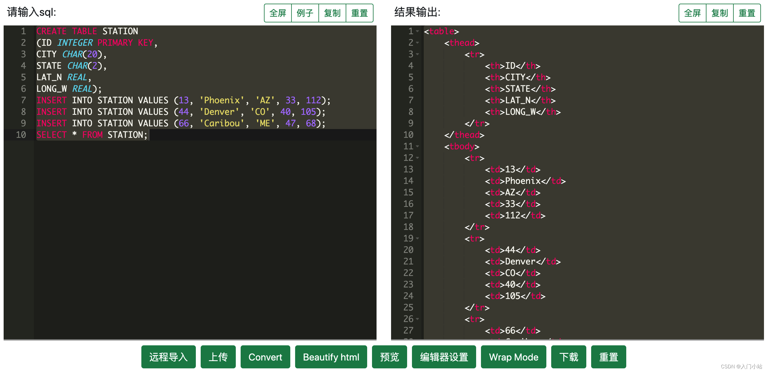
在线SQL转HTMLTable工具

任职 22 年,PowerShell 之父将从微软离职:曾因开发 PowerShell 被微软降级过
![[FreeRTOS] 08 mutex semaphores and priority inversion](/img/16/9715d5599db6ec107c8001fbd70ae2.png)
[FreeRTOS] 08 mutex semaphores and priority inversion

Free books! The best-selling book "Introduction and practice of OpenCV image processing" has been completed
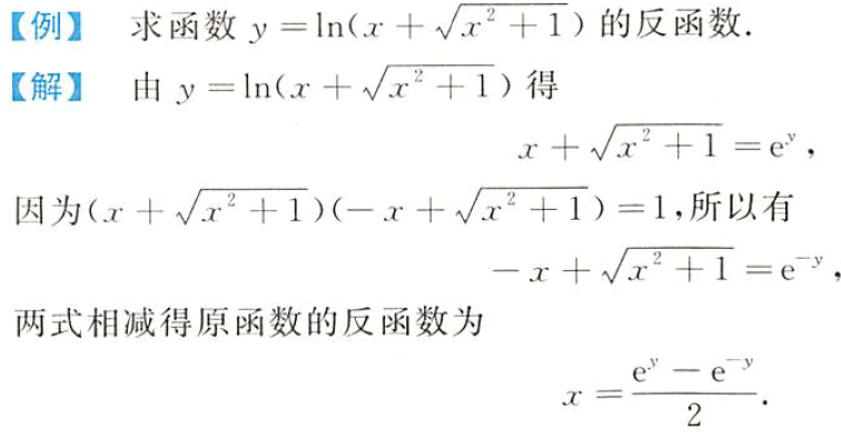
math_数学表达式&等式方程的变形&组合操作技巧/手段积累

Agctfb partial solution

罗清启:高端家电已成红海?卡萨帝率先破局

Software test model (V model and W model)

STM32F1与STM32CubeIDE编程实例-超声波测距传感器驱动

【Rust每周一库】Tokei - 统计代码行数等信息的实用工具
随机推荐
C language printf family
(JS)数组中纯函数
What happened during the MySQL installation?
8年打磨,《游戏设计梦工厂》发布史诗级更新!
这个mySQL安装的时候怎么搞去了?
NUC980开源项目16-从SPI FLASH(W25Q128)启动
(JS)手写bind函数
VI exit exit VIM applicable novice
你的项目需要自动化测试吗?
深入浅出总结Flink运行时架构
PyTorch学习笔记(6)——DataLoader源代码剖析
He was in '98. I can't play with him
(JS)观察者模式
zabbix监控mysql各项指标
加密市场接连爆雷,Celsius能避免破产吗?
基于STM32+RFID设计的宿舍检修管理系统
(JS)筛选出对象中value大于2的key
crypto 1~5
Detailed explanation of handwritten numeral recognition based on support vector machine (Matlab GUI code, providing handwriting pad)
【C语言进阶】特殊自定义类型