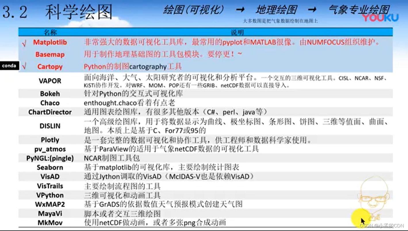
当前位置:网站首页>Miscellaneous notes -- a hodgepodge
Miscellaneous notes -- a hodgepodge
2022-07-25 20:40:00 【Xiao Meng's CDN】
Miscellany -- A hodgepodge
- Content
- Visio Shortcut key
- AI Shortcut key
- How to modify markdown The size of the picture in
- How many? DEM Data download website :
- About AI How to add arrows after creating them
- How to scale hatch patterns
- EDEM post-processing
- geopandas library
- Three kinds of Neural Networks
- Evaluation method of machine learning model
- letpub Scientific research information website :
- Idea
- Conventional acquisition method of global seabed multi beam terrain database Reading model
Content
Geological age unit refers to the time division unit in geological history , Not a physical entity , According to the level from high to low, it can be divided into Zhou 、 generation 、 Discipline 、 the 、 period . Chronostratigraphic unit refers to the formation time limit of strata ( Or geological age ) A stratigraphic unit divided as a basis , Or all strata formed in a specific geological time interval , From high to low, it can also be divided into five levels : Woo 、 world 、 system 、 system 、 rank . And the universe in the geological age unit 、 generation 、 Discipline 、 the 、 One by one correspondence . Popular point , Geological age unit represents time , Chronostratigraphic units represent the strata formed during this period
Hydrate saturation : Percentage of hydrate in sediment pores
Diapir structure : High plastic rock with low density deep underground ( Gypsum 、 Salt rock 、 Clay, etc ) It moves upward under the action of differential gravity , A geological structure formed by piercing the upper rock stratum . Diapir structure generally includes three parts :① Diapiric core composed of highly plastic material , It often presents complex plastic deformation ;② Supranuclear structure , It is a dome or short axis anticline formed by the uplift of the overlying strata , Often complicated by faults ;③ Subnuclear structure , It is generally simple . When the diapir core is rock salt , Also known as salt dome structure . Similar structures formed with magma as the core , It is called magma diapir . The attached drawing shows that the salt sediment penetrates upward in the direction of the arrow , And cut through the back slope in the overlying strata .
dxdiag Check the computer system information
View system and hardware information :systeminfo

Pumping test and micro water test are often used in the determination of hydrogeological parameters of aquifer . Disadvantages of pumping test method : One 、 When determining the permeability coefficient by pumping test , It will often cause certain disturbance to the hydrogeological conditions of the aquifer , Sediment may be extracted from the aquifer , Thus, it is impossible to effectively obtain the hydrogeological parameters of the aquifer without disturbance , The measurement of hydrogeological parameters cannot effectively reflect the “ natural ” state , Especially for some practical applications and scientific experiments that need to obtain hydrogeological parameters in the case of non disturbance ; Two 、 For some projects or projects , There may be test cycles 、 Power supply during the test 、 And for the sake of geological environment safety, it is not suitable to extract a large amount of groundwater ; 3、 ... and 、 Because pumping tests are often expensive , Therefore, it is difficult to realize long-term continuous dynamic monitoring of aquifer hydrogeological parameters . Disadvantages of micro water test : One 、 Due to the lack of unified test requirements and technical standards , The test equipment is imperfect , The data processing is tedious, and the measured permeability coefficient has a large deviation ; Two 、 The influence range of water level change caused by the test is limited , Therefore, the obtained hydrogeological parameters only represent the aquifer in a small range near the borehole ; 3、 ... and 、 Although the demand for human labor workload is small , However, it is still impossible to achieve and the continuous test to obtain the dynamic monitoring experimental data of hydrogeological parameters is not continuous . There are the following problems to be solved in the comprehensive monitoring of hydrogeological parameters of aquifers on the market :
In determining Of the many ways , The on-site monitoring operation is cumbersome , Difficult to achieve , Numerical simulation is time-consuming , It is quite different from reality , The invention aims at this problem based on providing a simple operation , Easy to apply Determine the method .
Meta earth and digital twin
Deep time deeptime:
Data assimilation :
Data assimilation (data assimilation) It refers to taking into account the space-time distribution of data and the error of observation field and background field , The method of fusing new observation data in the dynamic operation of the numerical model . It is within the dynamic framework of the process model , Through the data assimilation algorithm, the direct or indirect observation information from different sources and different resolutions of discrete distribution in space and time is continuously fused to automatically adjust the trajectory of the model , To improve the estimation accuracy of dynamic model state , Improve the prediction ability of the model . [1] Data assimilation is a method originally derived from numerical weather forecasting , Data processing technology to provide initial field for numerical weather forecast , It has been widely used in the field of atmosphere and ocean .
Meta universe (Metaverse) It is linked and created by scientific and technological means , A virtual world that maps and interacts with the real world , Digital living space with new social system . [12]
Metaverse;
BigANT
Big ant technology system
Deep time digital Twin Earth
Deep earth
normal form :
Coral reefs are good oil and gas reservoirs
Metal mineral prediction
Digital twin ocean
The key neck clamping technology of meta earth
AI Fill color and pattern at the same time , Create a new fill , In the hatch pattern

Visio Shortcut key
AI Shortcut key
Jupyter Split cells :
ctrl+shift+“-”
Can be researchgate As the first tool for literature review .
As well as web of science
Google Academy
China HowNet
How to modify markdown The size of the picture in
1 Method 1
This is CSDN Format after uploading pictures in ,pic.png For pictures , stay CSDN There will be long picture links in , Add a space after , Plus =100x20, The number is length and width , Change this number to change the size of the picture , Be careful not to miss = The space before the number

2 Method 2
stay Markdown Use some of HTML, Such as :
<img src="pic.png" alt="drawing" width="100"/>
<img src="pic.png" alt="drawing" style="width:100px;"/>
img[alt=drawing] {
     width: 200px; }
How many? DEM Data download website :
National Geographic Information System
https://earthexplorer.usgs.gov/
STRM data
https://srtm.csi.cgiar.org/srtmdata/
National Geospatial Data Cloud
http://www.gscloud.cn/search
About AI How to add arrows after creating them

How to scale hatch patterns
Select the toolbar scale tool , Hold down alt Double click the pattern , Set the transformation pattern scale 
matlab Histogram
Y=round(rand(5,3)*10)
subplot(2,2,1)
bar(Y,'group')
subplot(2,2,2)
bar(Y,'stack')
subplot(2,2,3)
barh(Y,'stack')
subplot(2,2,4)
bar(Y,1.5)
EDEM post-processing
EDEMpy
EDEMpy video
geopandas library
Geographic mapping python library
CMD When switching drive letters :
no need cd, direct F:
It can only be used under the specific drive letter cd
This kind of diagram can be used arcpy perhaps geopandas To draw 
This website can be downloaded 90*90 Accurate DEM data
https://download.geoservice.dlr.de/TDM90/#download
It is necessary to test the multicollinearity of data before machine learning
multicollinearity multiple Collinearity
variance inflation factor Variance expansion factor
Data processing and Feature Engineering
- One dimensional convolutional neural networks include : Input layer 、 Convolution layer 、 Pooling layer 、 Full connection layer and output layer .
IGR The information gain ratio is used to judge the contribution of each factor to the result
Three kinds of Neural Networks
Artificial neural network ANN
Convolutional neural networks CNN
Cyclic neural network RNN
How many? shp File download website :
Resource data center, Institute of geography, Chinese Academy of Sciences
account number :mxs12738
password :159753jkl469M
link : Resource data center, Institute of geography, Chinese Academy of Sciences
Evaluation method of machine learning model
After adoption Cohen’s Kappa Coefficient method 、Sridevi Jadi Accuracy evaluation method and ROC curve 3 Three methods are used to compare and analyze the evaluation results ,
letpub Scientific research information website :
Idea
- Submarine canyon recognition , Artificial intelligence recognition of Canyon axis and contour
7 Data of Three Gorges
- Artificial intelligence classification of seabed geology
- Machine learning recognition of submarine landform
- Submarine landslide / Artificial intelligence prediction of liquefaction
- Prediction of porosity of seafloor sediments by machine learning method
- Types of seafloor sediments 、 density 、 Porosity prediction
- At present, it is 5’×5’ The global scale data set of has , Pores of sediments in offshore China 、 Density has not been studied yet , high resolution , The East China Sea 、 South China Sea 、 The Yellow Sea
Conventional acquisition method of global seabed multi beam terrain database Reading model
oceaner Landlord Published in Research tools 2021-8-3 19:25:52 Just watch the author report reply
I believe that seabed topography is often used in Marine Science , Now we share two commonly used global seabed multi beam terrain databases :
1、NOAA Geophysical data center (NGDC):
Download address :https://maps.ngdc.noaa.gov/viewers/autogrid/ advantage :(1) The data is very complete ;(2) High data accuracy ;(3) Both the original data and the processed data can be downloaded .
shortcoming :(1) Download is slow , If you want to download high-precision data , You need to submit a lot of download tasks ;(2) The server is occasionally unstable .
2、MGDS Of Global Multi-Resolution Topography (GMRT)
Download address :http://www.marine-geo.org/tools/maps_grids.php
advantage :(1) Downloading is very convenient ;(2) The operation is relatively simple ;(3) The server is stable .
shortcoming :(1) The data is relatively less ;(2) It seems that you need to climb over the wall .
A beautiful world topographic map download website :
The world topographic map includes water depth data download website
Multi beam sounding data download
Special data format :
ETOPO1 is a 1 arc-minute global relief model of Earth’s surface that integrates land topography and ocean bathymetry. It was built from numerous global and regional data sets. Data were converted to the PanMap layer format in 14 contour lines from 500 to 7000 meter in steps of 500 m. The link provides a zip-archive (1.1 MB) with *.lay files. The PanMap Mini-GIS software is published at doi:10.1594/PANGAEA.104840.
边栏推荐
- Solution to oom exceptions caused by improper use of multithreading in production environment (supreme Collection Edition)
- [workplace rules] it workplace rules | poor performance
- Leetcode customs clearance: hash table six, this is really a little simple
- 【高等数学】【5】定积分及应用
- Technology cloud report: more than zero trust, the wild hope of Parra's "Digital Security Cloud strategy"
- matlab----EEGLab查看脑电信号
- FanoutExchange交换机代码教程
- [leetcode] 28. Implement strstr ()
- Follow up of Arlo's thinking
- leetcode-6129:全 0 子数组的数目
猜你喜欢
![[today in history] July 2: BitTorrent came out; The commercial system linspire was acquired; Sony deploys Playstation now](/img/7d/7a01c8c6923077d6c201bf1ae02c8c.png)
[today in history] July 2: BitTorrent came out; The commercial system linspire was acquired; Sony deploys Playstation now
![Vulnhub | dc: 6 | [actual combat]](/img/7e/de7d5b56724bde5db2bb8338c35aa8.png)
Vulnhub | dc: 6 | [actual combat]

During the interview, I was asked how to remove the weight of MySQL, and who else wouldn't?

If the order is not paid for 30 minutes, it will be automatically cancelled. How to achieve this? (Collection Edition)

Leetcode-6125: equal row and column pairs

The database empties the table data and makes the primary key start from 1
![[advanced mathematics] [1] function, limit, continuity](/img/c5/f9fd3814a61d0fba24b37253c7e51c.png)
[advanced mathematics] [1] function, limit, continuity

Struct, enum type and union
![[advanced mathematics] [6] differential calculus of multivariate functions](/img/9e/84fe6f74b58cbaabab1b6eed0df556.png)
[advanced mathematics] [6] differential calculus of multivariate functions

Leetcode-6130: designing digital container systems
随机推荐
wokerman 自定义写入日志文件
How to realize reliable transmission with UDP?
JS scope and scope chain
[today in history] July 3: ergonomic standards act; The birth of pioneers in the field of consumer electronics; Ubisoft releases uplay
Arrow 之 Parquet
[advanced drawing of single cell] 07. Display of KEGG enrichment results
[advanced mathematics] [5] definite integral and its application
leetcode-6129:全 0 子数组的数目
【ONNX】pytorch模型导出成ONNX格式:支持多参数与动态输入
[today in history] July 17: Softbank acquired arm; The first email interruption; Wikimedia International Conference
Fanoutexchange switch code tutorial
[advanced mathematics] [4] indefinite integral
leetcode-6127:优质数对的数目
Principle analysis of bootloader
Today's sleep quality record 75 points
Apache Mina framework "suggestions collection"
Remote—基本原理介绍
Success factors of software R & D effectiveness measurement
Online random coin tossing positive and negative statistical tool
[today in history] July 8: PostgreSQL release; SUSE acquires the largest service provider of k8s; Activision Blizzard merger