当前位置:网站首页>How to gracefully solve the offset problem of Baidu and Gaode maps in leaflet
How to gracefully solve the offset problem of Baidu and Gaode maps in leaflet
2022-06-12 23:48:00 【GIS weapon warehouse】
Don't talk much , First on the renderings

I used to work on projects , I often hear customers say , Where did you get this map , Too ugly , Can you change it to Baidu map …… Gorde will do ……
In everyone's life , Basically, they are used to using Baidu map and Gaode map , While working on the project , Use these two maps as the base map , It has basically become a standard configuration . But use these two maps in development , Will encounter a roadblock , Coordinate offset problem .
The most commonly used coordinates in the world , yes wgs84 coordinate , major GPS Devices and mobile phones GPS Coordinates obtained by positioning , It's usually this coordinate . Our country needs to keep secrets , Internet map required to be released in China , The encryption offset must be performed on this basis . The encrypted coordinates are called the coordinates of the State Survey Bureau , Commonly known as Mars coordinates . Gould map 、 Tencent map 、 This coordinate is used by Google maps in China . Baidu map is encrypted again on the basis of Mars coordinates , Baidu coordinates are formed .
leaflet There is a plug-in that loads Internet maps leaflet.ChineseTmsProviders, It is easy to load Godspeed 、 Baidu 、 Sky map 、 Google and other online map tiles , But we did not solve the problem of their offset . Gaode and Baidu map provide wgs84 Online interface for converting coordinates to own coordinates , But only one-way transfer in is supported , Reverse rotation is not supported , This will cause functions such as map picking coordinates to be unavailable wgs84 coordinate .
A copy of wgs84 coordinate 、 Mars coordinates and Baidu coordinates between the conversion algorithm . Found after being used in multiple projects , Basically very accurate , There are occasional errors , But very small , Within a few meters , I can hardly feel it when I use it .
How to integrate into leaflet
Two ways of thinking :
The first one is , The correction algorithm is encapsulated into an interface , Similar to Baidu mentioned above 、 Coordinate conversion interface of Gaud map , Before loading data into the map , First call this interface to complete the coordinate conversion, and then add it to the map . It is equivalent to shifting your own data to the coordinates of the Internet map . This is the most common .
The second kind , Baidu 、 Gaud's maps are all tile maps , Each tile will calculate its longitude and latitude position when it is loaded , We can add a correction algorithm when calculating the longitude and latitude position , Correct the coordinate position of the tile . When all the tiles are in the right position , There is no offset in the whole map . It is equivalent to correcting the tile of Mars coordinate or Baidu coordinate back to wgs84 coordinate .
The two schemes are compared , The first is obviously by Baidu 、 Gaud's coordinate conversion interface is rhythmic .leaflet It's open source. , We can correct the deviation of tiles by studying the source code , So as to truly correct the deviation of the map , Instead of calling the coordinate conversion interface every time , Let the data go wrong .
The second scheme can be further extended , Package the correction of tiles into plug-ins , The ultimate goal is to automatically correct the deviation of the map after the plug-in is introduced .
Tile position
Correct the deviation of tiles , First find the loading tile 、 Where is the code to calculate the tile position .
As mentioned above , Load the plug-in of Internet map leaflet.ChineseTmsProviders It is essentially a layer , It inherited TileLayer

TileLayer Inherited GridLayer
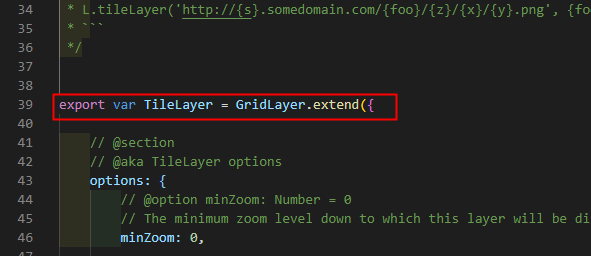
The code to load tiles is mainly in GridLayer Written in .
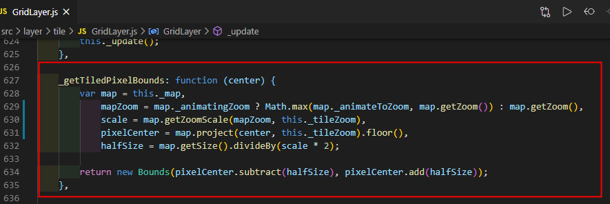
The code to calculate the tile position is in _getTiledPixelBounds Methods and _setZoomTransform In the method .

Tile rectification
Tile rectification is divided into three steps :
First step : Prepare the algorithm for coordinate conversion

The second step : Get the coordinate type according to the Internet map name

The third step : In the method of obtaining tiles and zooming the map , Call the correction algorithm

Packaged as plug-ins
There is a problem , Since you want to package it as a plug-in , It is necessary to achieve coupling , Cannot be modified directly leaflet Source code . Here you can refer to leaflet Source code , Use include Method to rewrite the method to modify the source code .
include The way
Let's learn about : such as leaflet Source code Polygon.toGeoJSON() The method is not in Polygon.js It's written in the document , It's about using include The way is written in GeoJSON.js In file .Polygon Class doesn't have toGeoJSON() Methodical , This adds to the method . If Polygon Class already has toGeoJSON() Method , This will be written according to the order of execution , The later one will rewrite the first one .

Last , We encapsulate the above code into a js plug-in unit , This plug-in is cited , We can correct the deviation of the map , There's no need to write a line js Code , This is the real elegance in my mind .
Final effect
The following figure shows the comparison before and after referencing the correction plug-in :

Be careful :leaflet Will map After initialization , Coordinates of the first layer loaded , As a whole map Coordinates of , So after the map is initialized , To be the first to add an Internet map as an underlay .
summary
- leaflet There is a plug-in to load the domestic Internet map , But there is a problem of coordinate offset .
- Common offset coordinates include the coordinates of the State Survey Bureau and Baidu coordinates . There is one on the Internet wgs84 Coordinate national survey bureau coordinates and Baidu coordinates conversion algorithm , You need to integrate yourself into leaflet in
- The correction algorithm is integrated into leaflet There are two ways of thinking , One is to shift your data to the Internet map , The other is to correct the tiles of the Internet map back to their own data .
- Adopt the second idea , The correction algorithm is encapsulated into a plug-in , Correct the tile deviation of Internet map , The most elegant way to copy the source code in a plug-in .
Online example
Not familiar with github Children's shoes , You can search by wechat 《GIS Zeughaus 》 Or scan the QR code below , reply “ Map correction ” Get the download link of the correction plug-in .

This article will be updated frequently , Please read the original :http://gisarmory.xyz/blog/index.html?blog=leafletMapCorrection, To avoid being obsolete 、 Wrong knowledge misleads .
WeChat search 《GIS Zeughaus 》 Or scan the QR code above , Focus on GIS Armory official account , You can get GIS Article update .
This article adopts Creative Commons signature - Noncommercial use - Share in the same way 4.0 International licensing agreement Licensing . Welcome to reprint 、 Use 、 Re release , But be sure to keep the signature of the article 《GIS Zeughaus 》( Include links : http://gisarmory.xyz/blog/), Not for commercial purposes , Based on this revised work must be released with the same license .
边栏推荐
- 2202 resume making
- KConfig
- 线上真实排队系统重构案例分享——实战篇
- Huawei cloud elastic ECS use [Huawei cloud to jianzhiyuan]
- How to use Huawei cloud disaster tolerance solution to replace disaster recovery all-in-one machine
- Design MySQL table structure for message queue to store information data
- H5时代leaflet中还在用DivIcon?
- Industry reshuffle, a large number of programmers are going to lose their jobs? How can we break the current workplace dilemma
- 利率降低导致债券价格上涨
- Dry goods sharing | BitSet application details
猜你喜欢

So, what is the difference between e.target and e.currenttarget?

Alien skin exposure X7 color filter plug-in, raw post-processing tool

Ast, really fragrant
![[opencv learning] small ticket recognition based on perspective transformation and OCR recognition](/img/47/08b9dd9dbea9e9cb6deda975f4d652.jpg)
[opencv learning] small ticket recognition based on perspective transformation and OCR recognition

如何实现OSM地图本地发布并自定义配图

TCP与UDP

2202 resume making

支持Canvas的Leaflet.Path.DashFlow动态流向线

2022 R2 mobile pressure vessel filling test questions and online simulation test

VS2015 DLIB 1916 USER_ ERROR__ inconsistent_ build_ configuration__ see_ dlib_ faq_ 1 USER_ ERROR__ inconsiste
随机推荐
[redis sentinel] failed listening on port 26379 (TCP) & sentinel mode no response problem solved
Lower interest rates lead to higher bond prices
2022年危險化學品經營單比特安全管理人員考試試題及在線模擬考試
Redis realizes SMS verification code login
H5时代leaflet中还在用DivIcon?
妙才周刊 - 5
Divicon est toujours utilisé dans le leaflet de l'ère H5?
2202 resume making
[North Asia data recovery] data recovery cases in which the partitions disappear and the partitions are inaccessible after the server reinstalls the system
Alien Skin Exposure X7调色滤镜插件,RAW后期处理工具
Xi'an Jiaotong 22nd autumn e-commerce technology online expansion resources (IV) [standard answer]
[kubernetes guide ⑤] label quick start
The programmer has worked for 7 years. At the age of 31, he has no choice but to deliver takeout. I really don't want you to go through his journey again
Novice must see! How rust beginners write gear smart contracts (1)
[literature translation - Part] revealing the structure of clinical EEG signals by self supervised learning (SSL and RP principles / data / preprocessing)
2022年6月11日记:王老师的春天,混入
【Matlab】二维曲线
2022年危险化学品经营单位安全管理人员考试试题及在线模拟考试
华为云会议初体验【华为云至简致远】
Basic operations of dict and set