当前位置:网站首页>What other data besides SHP data
What other data besides SHP data
2022-06-24 19:22:00 【Geographical space of ruiduobao】
File format Introduction
I was born in Dixin , I have been in contact with... Since my freshman year arcgis, now 7 Over the year . I like arcgis The power of , But I like it better QGIS Openness . Everyone has different software usage habits , It seems to me that QGIS Than arcgis Well done ,gson Than shp To use .
Although there are currently more than 80 Vector data format , But considering the openness of data format , At present, there are only a few challenges SHP Industry hegemony . They are :
- OGC GeoPackage
GeoPackage It's kind of open 、 Platform independent 、 Portable format , It can be used to transmit geospatial information . Exists as a single file , Support vector and grid formats .

- FlatGeobuf
FlatGeobuf It is a binary coded single file that describes spatial geographic information , Systems that are critical to performance , It is suggested that FlatGeobuf As Shapefile succedaneum .
- GeoJSON
GeoJSON It is suitable for processing complex vector data and constructing complex hierarchical data model , This data is easy to parse , And supports streaming ( No need to wait for the entire file to load ).

- OGC GML
GML Was chosen as Europe INSPIRE The main vector data formats of the initiative , But its standards are complex , Very little software supports the entire standard .

- SpatiaLite
SpatiaLite It's an open source library , To expand SQLite Core to support mature Spatial SQL function , The entire database only corresponds to a single overall file ( No size limit ).SpatiaLite And GeoPackage Are built on the underlying technology SQLite above .
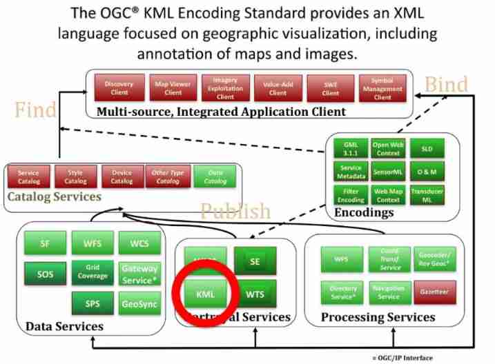
- OGC KML
KML Is based on XML Of , Inefficient for storing large data sets , In addition, this format only supports WGS-84 Coordinate system .
Document comparison
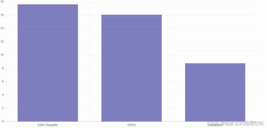
(1) Maximum value of file (G)

(2) Reading the metadata of a file takes time ( second )

(3) adopt FID Querying data takes time ( second )

(4) It takes time to read the same data in different formats ( second )
(5) It takes time to set conditions to filter out regions of interest ( second )

Sum up ,shp File processing is inefficient . in addition , The most inconvenient thing for users is Number of documents .
ESRI The company relies on its own market advantages ,SHP Format dominance GIS market . Decades passed , Technology is improving , Standing on the shoulders of giants , Maybe we can use better data formats or create better geographic data formats .
When looking for information , I found the Shapefile Must Die Website GitHub Warehouse , Interested colleagues can study .

Reference resources :
GitHub.https://github.com/opengeolabs/shapefilemustdie
Switch from Shapefile.http://switchfromshapefile.org/
边栏推荐
- 实时渲染:实时、离线、云渲染、混合渲染的区别
- 想问下 pgsql cdc 账号同一个 多个 task 会有影响吗,我现在3个task 只有一个 有
- The sharp sword of API management -- eolink
- 华为机器学习服务语音识别功能,让应用绘“声”绘色
- A detailed explanation of the implementation principle of go Distributed Link Tracking
- Will the CDC read out of order when I use SQL
- Why are life science enterprises on the cloud in succession?
- Introduction and tutorial of SAS planet software
- Unity mobile game performance optimization spectrum CPU time-consuming optimization divided by engine modules
- NFT双币质押流动性挖矿系统开发
猜你喜欢

How to protect biological privacy in the AI era? Overview of the latest "privacy enhancement technology in biometrics" of the Autonomous University of Madrid, comprehensively detailing the biometric p

starring开发HttpJson接入点+数据库

工作6年,月薪3W,1名PM的奋斗史

php OSS文件讀取和寫入文件,workerman生成臨時文件並輸出瀏覽器下載
Introduction and download tutorial of administrative division vector data

Make track map

High dimension low code: component rendering sub component
Microsoft planetary computer (MPC) platform introduction, registration and comparison

Unity mobile game performance optimization spectrum CPU time-consuming optimization divided by engine modules

Freeswitch uses origin to dialplan
随机推荐
佛祖保佑 永无BUG
How to customize cursor position in wechat applet rotation chart
Microsoft planetary computer (MPC) platform introduction, registration and comparison
上位机与MES对接的几种方式
Sr-gnn shift robot gnns: overlapping the limitations of localized graph training data
【计算讲谈社】第三讲:如何提出关键问题?
60 divine vs Code plug-ins!!
mysql binlog 数据源配置文档麻烦分享一下
模块五
制造业项目MDM主数据项目实施心得
Fabric 账本数据块结构解析(一):如何解析账本中的智能合约交易数据
Starring develops httpjson access point + Database
Introduction and tutorial of SAS planet software
IBPS开源表单设计器有什么功能?
Sr-gnn shift robot gnns: overlapping the limitations of localized graph training data
一次 MySQL 误操作导致的事故,高可用都不顶不住!
A detailed explanation of the implementation principle of go Distributed Link Tracking
请问一下2.2.0版本支持动态新增mysql同步表吗
论文解读(SR-GNN)《Shift-Robust GNNs: Overcoming the Limitations of Localized Graph Training Data》
Xiaodi class massive data processing business short chain platform