当前位置:网站首页>One "stone" and two "birds", PCA can effectively improve the dilemma of missing some ground points under the airborne lidar forest
One "stone" and two "birds", PCA can effectively improve the dilemma of missing some ground points under the airborne lidar forest
2022-06-25 07:46:00 【Oxygen technique】
One “ stone ” Two “ bird ”,PCA Effectively improve Airborne LiDAR The dilemma of missing ground points under the forest
One 、“ Penetration capability 、 But no penetration ” Plight
Airborne lidar measurement technology has high efficiency 、 High precision 、 It is widely used in topographic mapping because of the advantage of directly obtaining the point cloud which reflects the three-dimensional geometric shape and spatial distribution of the physical world 、 Forestry resources survey 、 Electric power line patrol inspection and other fields . The working principle of airborne lidar is shown in the figure below :

in addition , Lidar “ Penetrability ” It is also a remarkable feature that distinguishes it from other remote sensing technologies . Laser radar “ Penetrability ” It means that the laser beam has the ability to pass through the vegetation canopy 、 Obtain vegetation points that reflect the internal structure characteristics of vegetation 、 And the ability of ground points under the forest , As shown in the figure below :
Thanks to the penetration of lidar , Airborne lidar technology has the ability to accurately obtain the terrain under the forest 、 Accurately obtain the height of trees 、 The ability to retrieve the internal structural characteristics of vegetation , As shown in the figure below :
however , Given the complexity of the physical world 、 Lidar hardware performance 、 There are many factors in aviation , Laser radar “ Ability to penetrate vegetation ”、 But that doesn't mean you can “ In any case, it can penetrate the vegetation ”. In some cases , The ground points under the forest are still missing , As shown in the figure below :
A large area of ground points under the forest are missing for topographic mapping 、 The application of forestry resources investigation and other industries has brought great trouble . To ensure the integrity and accuracy of the terrain , People have taken various remedial measures : Some of them need to be edited manually , Some require the use of foundations 、 hold 、 knapsack 、 Supplement data by means of manual measurement .
Two 、 Lidar can't ,PCA To help
“ Point cloud wisdom painting PCA Software ” Comprehensive utilization of deep learning 、 The migration study 、 Machine learning methods such as Bayesian learning partially solve the impenetrable problem .
use PCA Of 3.5 edition , stay “ pro ” In mode , You can filter in the point cloud 、 At the same time, a set of ground point cloud data consistent with the original point cloud range is calculated by machine learning .PCA The settings of the professional version are shown in the following figure :
“ pro ” In mode , function “ Dajiang L1 Industry application module ” Under the “ Fine terrain extraction ” Point cloud filtering tools of corresponding sub modules , While filtering the origin cloud file and saving the results , An additional... Will be output “ original file name +InterpolatedPoints.las” New point cloud file , This new file stores PCA Interpolated ground clouds .
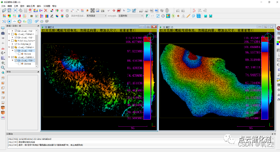
The following figure shows the ground points obtained from the point cloud data of a certain area through point cloud filtering ( Left view )、 Calculated ground point ( Right side view ):
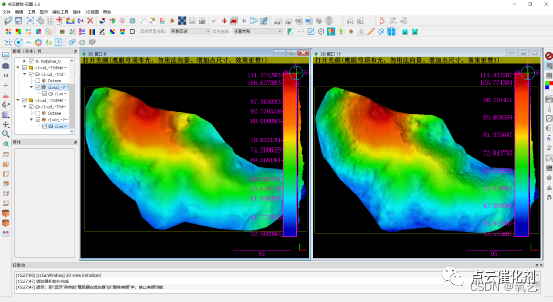
The following figure shows the generation of ground points obtained by point cloud filtering TIN Model ( Left view )、 Generated by the calculated ground points TIN Model ( Right side view ):
in addition , We make use of PCA Of “ Earthwork calculation ” The tool obtains the elevation difference data of the two point clouds of the identified ground point set and the calculated ground point set 、 And assign the elevation difference to the point cloud as a scalar field ( attribute ). The following figure shows the ground points obtained from the point cloud data of a certain area through point cloud filtering ( Left view )、 The height difference between the calculated ground point and the ground point obtained by filtering ( Right side view ):
When the ground points under the forest are sparse due to the impervious laser radar , Combined with the above three renderings , We found that PCA The results obtained have the following rules :
(1)PCA The ground points identified by the filter itself are also rare ; but PCA The extrapolated ground points are approximately uniformly distributed .
(2)PCA Generated by the ground points identified by the filter itself TIN Large triangles will appear 、 Lead to TIN The local area of the model appears to have obvious unevenness ; but PCA Generated by extrapolated ground points TIN Is more continuous and smooth .
(3)PCA The ground point set identified by the filter itself is related to PCA Height difference of the ground point set obtained by extrapolation , The elevation difference in most areas is close to 0、 However, the height difference in a few areas is large . The higher the density of ground points identified by itself , The smaller the height difference between the two ; conversely , The smaller the density of ground points identified by itself , The greater the height difference between the two . But the terrain and geomorphic features of the integrated scene ,PCA The extrapolated ground point set is more consistent with the inherent landform . This requires progressive instance data validation .
(4) If the original point cloud data has data holes , The data hole area cannot generate extrapolation points . namely ,PCA The software only extrapolates the ground points in the area with LIDAR point distribution , However, the ground points in the cavity area cannot be extrapolated . This rule is shown in the figure below , The original point cloud is rendered with elevation 、 The extrapolated ground points are rendered with categories ( khaki ).

in addition ,PCA The density of the ground point set obtained by extrapolation is adjustable . The parameter for adjusting the density of extrapolated ground point set is “ The shortest triangle side length ”. The smaller the side length , The higher the density of the extrapolated ground point cloud ; conversely , The smaller the density .“ The shortest triangle side length ” The location is shown in the figure below :

Be careful : And “ pro ” Different ,“ Xiaobaiye ” In mode , Users can only realize point cloud filtering and ground point recognition with the same module .
3、 ... and 、 Technical steps and case presentation
We use the point cloud data of UAV lidar in a mountainous area of Sichuan as the case data , Show how to use PCA The calculated ground points can make up for the lack of original point cloud ground points . The scene corresponding to the point cloud data shows high mountains and dense forests , The UAV lidar system for data acquisition was developed by an enterprise in Sichuan , The overview is shown in the figure below :

The specific operation steps are as follows :
(1) take PCA The software “ Yun Xiang ” Set to “ pro ”.
(2) Import point cloud data into “ Yun Xiang ” in .
(3)“ Yun Xiang ” Of “ pro ” In mode , Use corresponding “ Dajiang L1 Industry application module ” Under the “ Fine terrain extraction ” The point cloud filtering tool of each corresponding sub module performs filtering .
(4) The filtered point cloud data 、 The newly generated calculated ground point file “ original file name +InterpolatedPoints.las” Import to “ Cloud chart ” in .
(5) By drawing polygons , Make up the ground points
In the filtered point cloud data, there is indeed a lack of ground points in the local forest coverage area due to the lack of laser penetration , As shown in the figure below :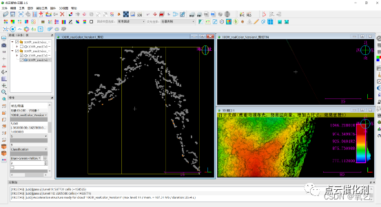
PCA The calculated ground points are shown in the figure below :
PCA The local enlarged view of the calculated ground points is shown in the figure below :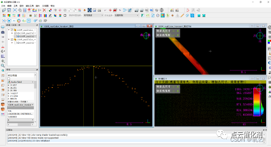
Four 、 Summary
In a local scene , The laser radar cannot penetrate the vegetation canopy to obtain the ground points under the forest .PCA The software can filter in the point cloud 、 At the same time, a set of ground points matching the original point cloud are calculated . The ground points under some forests are missing 、 However, the ground points cannot be supplemented by other measurement means , The original ground points can be supplemented or replaced by the calculated ground points in the same local area , It can partly solve the problem of laser radar “ Penetration capability 、 But no penetration ” Plight .
however , We suggest , When the lidar can obtain the ground points under the forest , The user uses the ground points in the original LIDAR point cloud to ensure the accuracy of the point cloud .
边栏推荐
- [batch dos-cmd command - summary and summary] - CMD window setting and operation commands (CD, title, mode, color, pause, CHCP, exit)
- Pit encountered by pytorch: why can't l1loss decrease during model training?
- Shell tips (134) simple keyboard input recorder
- Chuantu microelectronics breaks through the high-end isolator analog chip market with ca-is3062w
- JDBC-DAO层实现
- 【批处理DOS-CMD命令-汇总和小结】-应用程序启动和调用、服务和进程操作命令(start、call、)
- VectorDraw Web Library 10.10
- 一次弄清楚 Handler 可能导致的内存泄漏和解决办法
- 指南针可以开股票账户吗?安全吗?
- [batch dos-cmd command - summary and summary] - commands related to Internet access and network communication (Ping, Telnet, NSLOOKUP, ARP, tracert, ipconfig)
猜你喜欢
Ns32f103c8t6 can perfectly replace stm32f103c8t6

【批處理DOS-CMD命令-匯總和小結】-cmd擴展命令、擴展功能(cmd /e:on、cmd /e:off)

Construction of occupancy grid map
图扑软件数字孪生 3D 风电场,智慧风电之海上风电

基于地面点稀少的LiDAR点云的茂密森林蓄积量估算

Terms and concepts related to authority and authentication system
![Insert and sort the linked list [dummy unified operation + broken chain core - passive node]](/img/2a/ccb1145d2b4f9fbd8d0812deace93b.png)
Insert and sort the linked list [dummy unified operation + broken chain core - passive node]
Function template_ Class template
![[batch dos-cmd command - summary and summary] - file and directory operation commands (MD, RD, xcopy, dir, CD, set, move, copy, del, type, sort)](/img/fd/1d83ab3b318413ddf70f4e68b28cc3.png)
[batch dos-cmd command - summary and summary] - file and directory operation commands (MD, RD, xcopy, dir, CD, set, move, copy, del, type, sort)

OpenCV每日函数 结构分析和形状描述符(8) fitLine函数 拟合直线
随机推荐
Elk + filebeat log parsing, log warehousing optimization, logstash filter configuration attribute
CPDA | how to start the growth path of data analysts?
Modular programming of digital light intensity sensor module gy-30 (main chip bh1750fvi) controlled by single chip microcomputer (under continuous updating)
Sichuan earth microelectronics ca-is1200 isolated operational amplifier for current detection
Terms and concepts related to authority and authentication system
数据可视化没有重点怎么办?
Runtime——methods成员变量,cache成员变量
JMeter introduction practice ----- use of global variables and local variables
海思3559 sample解析:vio
Five causes of PCB board deformation and six solutions 2021-10-08
Evolution of Alibaba e-commerce architecture
【批处理DOS-CMD命令-汇总和小结】-cmd扩展命令、扩展功能(cmd /e:on、cmd /e:off)
Chuantu microelectronics ca-if1051 can-fd transceiver
“空间转换”显著提升陡崖点云的地面点提取质量
图扑软件数字孪生 3D 风电场,智慧风电之海上风电
对链表进行插入排序[dummy统一操作+断链核心--被动节点]
C get the version number of exe - file version and assembly version
VectorDraw Developer Framework 10.10
Function template_ Class template
Accès à la boîte aux lettres du nom de domaine Lead à l'étranger