当前位置:网站首页>Conversion relationship between coordinate systems (ECEF, LLA, ENU)
Conversion relationship between coordinate systems (ECEF, LLA, ENU)
2022-06-11 05:00:00 【Immediately】
One Introduction to coordinate system
1 ECEF Coordinate system
Also called geocentric geostationary rectangular coordinate system . Its origin is the center of mass of the earth ,x The axis extends through the prime meridian (0 Longitude ) And the equator (0deglatitude) The intersection of . z The axis extends through the North Pole ( namely , Coincide with the earth's rotation axis ). y The axis completes the right-hand coordinate system , Across the equator and 90 Longitude .
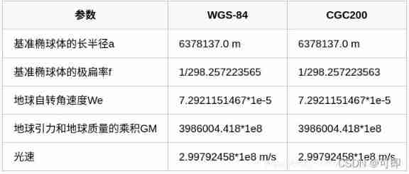
2 WGS-84 Coordinate system (LLA)
It is also called the longitude and latitude coordinate system ( longitude (longitude), latitude (latitude) And height (altitude)LLA Coordinate system )., Global geographic coordinate system 、 Geodetic coordinate system . It is the most widely used earth coordinate system , It gives the geodetic latitude of a point 、 The earth longitude and earth elevation tell us the position of the point in the earth more intuitively , Therefore, it is also called longitude latitude high coordinate system .WGS-84 In coordinate system X Axis pointing BIH( International time service )1984.0 Defined zero meridian plane (Greenwich) And agreement earth pole (CTP) The intersection of the equator .Z Axis pointing CTP Direction .Y Shaft with X、Z The axis forms the right-hand coordinate system .
In a word, the explanation is : Put the previously mentioned ECEF The coordinate system is used in GPS in , Namely WGS-84 Coordinate system .
among :
(1): The geodetic latitude is the crossing point P The angle between the normal of the reference ellipsoid and the equatorial plane . Latitude value at -90° To +90° Between . The northern hemisphere is positive , Negative in the southern hemisphere .
(2): The earth longitude is the point of transit P The angle between the meridian of and the prime meridian . Longitude value at -180° To +180° Between .
(3): Earth height h It is the user point P The normal distance to the datum ellipsoid , Negative within the reference ellipsoid , The outside is positive .
 3 Northeast sky coordinate system (ENU)
It is also called the station center coordinate system, which is based on the user's location P It's the origin of the coordinates .
The coordinate system is defined as : X Axis : Point East Y Axis : Point north Z Axis : Point to the zenith
ENU The local coordinate system uses a three-dimensional rectangular coordinate system to describe the earth's surface , Practical application is difficult , Therefore, the simplified two-dimensional projection coordinate system is generally used to describe . In many two-dimensional projection coordinate systems , Unified horizontal Mercator (The Universal Transverse Mercator ,UTM) Coordinate system is a kind of widely used .UTM The coordinate system uses a grid based method to represent coordinates , It divides the earth into 60 Longitude zones , Each zone contains 6 The longitude range of degrees , The coordinates in each zone are based on the transverse Mercator projection , As shown in the figure below :

Two Transformation between coordinate systems
LLA The coordinate system turns ECEF Coordinate system 
** ECEF The coordinate system turns LLA Coordinate system **
ECEF Points in the coordinate system (X,Y,Z) Convert to LLA In a coordinate system (lon,lat,alt)
In limine lon It is unknown. , We can assume that 0, It can converge after several iterations
update:alt=(p/cos(lat))-N
ECEF The coordinate system turns ENU Coordinate system
User's coordinate origin 𝑃0=(𝑥0,𝑦0,𝑧0), Calculation point 𝑃=(𝑥,𝑦,𝑧) In order to point 𝑃0 Is the origin of the coordinates ENU Coordinate system position (e,n,u) I need to use LLA Data in coordinate system ,𝑃0 Of LLA The coordinate point is 𝐿𝐿𝐴0=(𝑙𝑜𝑛0,𝑙𝑎𝑡0,𝑎𝑙𝑡0)
ENU The coordinate system turns ECEF Coordinate system 
LLA The coordinate system is directly rotated ENU Coordinate system
As can be seen above , from LLA Coordinate system conversion to enu The coordinate system has a lot of calculation , Considering the eccentricity of the earth 𝑒 Very small premise , Can do some approximate formula calculation 
边栏推荐
- Real time update of excellent team papers
- 一大厂95后程序员对部门领导不满,删库跑路被判刑
- Paper recommendation: relicv2, can the new self supervised learning surpass supervised learning on RESNET?
- lower_bound,upper_bound,二分
- Huawei equipment is configured with bgp/mpls IP virtual private network
- Huawei equipment is configured to access the virtual private network through GRE
- Paper reproduction: pare
- Dongmingzhu said that "Gree mobile phones are no worse than apple". Where is the confidence?
- AAAI2022-ShiftVIT: When Shift Operation Meets Vision Transformer
- [aaai 2021 timing action nomination generation] detailed interpretation of bsn++ long article
猜你喜欢

Huawei equipment is configured to access the virtual private network through GRE tunnel

Parametric contractual learning: comparative learning in long tail problems

Paper recommendation: relicv2, can the new self supervised learning surpass supervised learning on RESNET?

Emlog new navigation source code / with user center
![[Transformer]Is it Time to Replace CNNs with Transformers for Medical Images?](/img/83/7025050667c382857c032bdd8f6649.jpg)
[Transformer]Is it Time to Replace CNNs with Transformers for Medical Images?

Tightly coupled laser vision inertial navigation slam system: paper notes_ S2D. 66_ ICRA_ 2021_ LVI-SAM

华为设备配置MCE
![[aaai 2021 timing action nomination generation] detailed interpretation of bsn++ long article](/img/28/d69a7583036a2076facffcf9098d7e.jpg)
[aaai 2021 timing action nomination generation] detailed interpretation of bsn++ long article

Emnlp2021 𞓜 a small number of data relation extraction papers of deepblueai team were hired

Yolov5 training personal data set summary
随机推荐
New product release: Lianrui launched a dual port 10 Gigabit bypass network card
华为设备配置跨域虚拟专用网
How to purchase 25g optical network card
Meedu knowledge payment solution v4.5.4 source code
KD-Tree and LSH
How to quickly find the official routine of STM32 Series MCU
go MPG
lower_ bound,upper_ Bound, two points
Chia Tai International; What does a master account need to know
RGB image histogram equalization and visualization matlab code
Sealem Finance打造Web3去中心化金融平台基础设施
Possible errors during alphapose installation test
董明珠称“格力手机做得不比苹果差”哪里来的底气?
Reverse thinking: making cartoon photos real
Visual (Single) Object Tracking -- SiamRPN
jvm调优五:jvm调优工具和调优实战
Split all words into single words and delete the product thesaurus suitable for the company
An adaptive chat site - anonymous online chat room PHP source code
New library goes online | cnopendata immovable cultural relic data
华为设备配置MCE