One 、 from BIM+GIS To CIM
2018 year 11 month , The Ministry of housing and urban rural development issued industry standards 《“ Multiple compliance ” Business collaboration platform technical standards 》 For advice , incentive “ A conditional city , Can be found in BIM Based on the application CIM”.
So what is CIM? First of all, we have to start with BIM Speak up .BIM It's a building information model , In short ,BIM It's around the design of Architecture 、 The construction of the 、 The whole life cycle of architecture from operation to the end , All kinds of information have been integrated into a 3D model information database .
utilize BIM This highly integrated 3D model , It greatly improves the information level of construction engineering , It provides a platform for the exchange and sharing of engineering information for all staff involved in construction projects . Rising in the field of engineering construction BIM Technology has been widely recognized and applied , It makes building construction more efficient 、 More green 、 More secure , Lower overall cost . However ,BIM In providing precise geographical location 、 There are deficiencies in the overall display of the surrounding environment of buildings and the analysis of spatial geographic information , And three dimensions GIS Just to supplement these deficiencies , Realize the geographical location of buildings and spatial analysis of surrounding environment , Perfect the display of big scenes , Make the information more perfect and comprehensive . Through the and GIS Technology convergence ,BIM The scope of application of the concept has expanded from single buildings to buildings and their roads 、 Tunnel 、 The railway 、 port 、 Hydropower and other engineering fields .
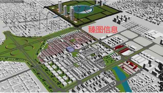
BIM Integrated is the overall information of urban buildings , and GIS Integrate and manage the external environment information of the building , A virtual city model with massive information . therefore , That leads to CIM The concept of .
CIM It refers to the city information model , It is based on city information data , Establish an organic synthesis of three-dimensional urban spatial model and urban information . In the narrow sense of data types ,CIM It's from the big scene GIS data +BIM Data make up , It is the basic data of smart city construction . be based on BIM and GIS Technology convergence ,CIM Accurate data granularity to individual modules within urban buildings , Strengthen the static traditional digital city into a perceptible one 、 Real time dynamic 、 Smart city of virtual and real interaction , It provides key data support for comprehensive urban management and fine governance .
CIM From the very beginning , It refers to the city information model . stay 2015 At the planning practice forum in , Academician Wu Zhiqiang of Tongji University CIM The concept of the concept has been further elevated , Put forward the city intelligence model . Academician Wu pointed out that ,BIM It's monomer ,CIM It's a group ,BIM yes CIM The cells . To solve the problem of smart city , Only by BIM This single cell is not enough , It's made up of massive cells and Internet connections CIM Can only be .
Regardless of “CIM” Letters in I Information or wisdom ,CIM The concept of this is put forward , The public's vision is elevated from the single building to the architectural complex or even the city level , Give smart city more powerful support .
stay CIM In the category of ,GIS It can provide the following four levels of competence : Ability to provide 2D and 3D integrated base map and unified coordinate system ; Provide each BIM The ability of monomers to connect to each other , For example, roads 、 Underground utility tunnel and pipeline, etc ; Provide spatial analysis and management capabilities ; Provide large-scale buildings BIM The ability to manage data .
The first three are GIS What tradition is good at , And it's been developed to maturity ; The last one is GIS stay CIM New challenges in the field . stay CIM On the level , The object of management is a region or even a city BIM data .BIM It's a huge amount of data , Of a single building BIM The data is as high as one or two hundred GB, It's made up of millions of 3D components . The amount of data at the city level is even more unimaginable . After years of development ,GIS The software not only realizes docking access BIM Data format of relevant software , And it realizes the management of large-scale buildings BIM The power of data .
Two 、 from CIM To digital twins
Number twin The word first came into being in industry , However, its application in smart city comes from 2018 Passed in 《 Xiong'an planning outline 》, The outline points out that :“ Adhere to the synchronous planning of digital city and real city 、 Simultaneous construction , Appropriate layout of intelligent infrastructure in advance , Building the world's leading digital city ”、“ Establish and improve the big data asset management system , To create a deep learning ability 、 The world's leading digital city ” And so on .
In recent years, in the process of urban construction ,CIM adopt BIM、 The three dimensional GIS、 big data 、 Cloud computing 、 The Internet of things (IoT)、 Intelligent and other advanced digital technology , Synchronous generation and physical city “ twin ” The digital city of , Realize the city from planning 、 The whole process from construction to management 、 All elements 、 Digital in all directions 、 Online and intelligent , Changing the face of the city , Reshaping urban infrastructure .
It can be understood in a broad sense from the following three levels CIM The composition of :BIM data , It's the data of a single city entity , It's the cells of the city ;GIS As the bearer of all data , Integrate the data ; meanwhile , adopt IoT by CIM The platform brings real-time display , Show the whole state of the objective world , This is it. “ Number twin ” The concept of the city .
CIM It is the fundamental core of the digital twin city , At the same time CIM extensibility , You can connect the population 、 House 、 Household water, electricity and gas information 、 Security police data 、 Traffic information 、 Tourism resources information 、 Public health care and other information resources of urban public system , Realize cross system application integration 、 Cross departmental information sharing , Decision analysis supporting the digital twin city .
Through the technology of digital twin city , Create a copy of the city in the virtual space , As a mirror image of a real city 、 mapping 、 Simulation and assistance , Planning for smart cities 、 Building 、 Operation management provides unified basic support .
1、 Urban planning simulation
Based on multi-source data and multi planning integration to achieve a map of planning management . Integrate all the underlying spatial data ( Three dimensional reality of the current situation of the city 、 topographic features 、 Geology, etc )、 Status data ( Population 、 land 、 House 、 traffic 、 Industry, etc )、 Planning results ( General plan 、 Regulatory planning 、 special 、 Urban design 、 Construction restriction elements, etc )、 Underground space data ( Underground space 、 Pipe gallery, etc ) And other information resources related to urban planning , Generating data to improve 、 Reasonable structure 、 Standardized and efficient data unified service system , Merge in the digital twin space 、 superposition , Resolve planning conflicts , Unifying spatial boundaries , Generate planning management “ A blueprint ”, Based on this, the planning evaluation is carried out 、 In many ways 、 Dynamic optimization and implementation of Supervision . In full assurance “ A blueprint ” Under the premise of real-time and effectiveness , Through the simulation and visualization of various planning schemes and results , Optimization and selection of implementation scheme .
2、 Urban construction management
In the design stage of urban construction planning , Using digital twin Technology , Build the environment around the restoration design , On the one hand, we can design interaction in a visual environment , On the other hand, it can fully consider the mutual influence and restriction between the design scheme and the existing environment , Let the problems that can be exposed to the construction link in advance in the virtual design process , It is convenient for designers to optimize these problems in time .
In the construction process , Using the spatial and temporal characteristics of objects in digital twin technology , Simulate the construction scheme and plan , Analyze the rationality of project schedule and plan in depth , All round management of construction process .
3、 Urban operation and maintenance management
In operation and maintenance management , Using the real-time data obtained by various Internet of things sensors and intelligent terminals in the city entity , be based on CIM Model , For urban infrastructure 、 Underground space 、 Road traffic 、 ecological environment 、 Real time monitoring and visualization of the operation of the energy system , Achieve predictive maintenance of equipment 、 Based on the simulation of decision-making deduction and comprehensive disaster prevention and emergency response capacity , Make the city run more smoothly 、 Safe and efficient .
At this stage , With CIM The technology-based digital twin planning, construction and management technology platform has moved from concept to achievement implementation , At present, in xiong'an New District 、 Beijing New Airport Airport Airport Economic Zone 、 Beijing City Sub Center 、 Fuzhou Binhai New City 、 Qingdao CBD 、 Beijing future science city and so on have carried on the practice , It has formed a good innovation demonstration effect and social value .
3、 ... and 、 Application and Prospect of digital twin in City
Digital twin cities bring about new changes in urban governance . A digital twin city built by superimposing model data , There are several incomparable advantages in supporting urban governance : One is to provide a panoramic view 、 Urban multi-dimensional monitoring and full data analysis , Forecast the development trend of the city in advance , Data driven management decisions , The management decision is verified by simulation , Online and offline virtual real iteration , Promote the optimal allocation of resources and capabilities , Promote scientific decision making ; The second is to promote fine management ,360 No dead angle monitoring , Three dimensional perception of land, sea and air , Urban governance can be planned and won thousands of miles away ; The third is to provide collaboration , Emergency response to emergencies , Global coordination and linkage , Call resources nearby . Next, some scenarios of digital twin in the construction of smart city are proposed :
1、 Digital twin optimizes travel . By taking the physical world of complex transportation systems , Using cloud computing 、 The Internet of things 、 Artificial intelligence 、 big data 、 Real 3D 、 Semantic technology to simulate , Build a digital twin traffic environment that can be understood by machines , Combined with multi-source heterogeneous traffic real-time data , Build a knowledge map of traffic information , Explore the big data of traffic time and space 、 Analysis and display , And then realize the traffic monitoring and early warning 、 Emergency treatment and congestion management and other functions .
2、 Digital twin promotes the development of intelligent driving . Through the digital twin to achieve the road 、 terrain 、 Traffic flow 、 traffic sign 、 The light 、 High precision simulation of weather, etc . Using high fidelity 、 Scenario rich simulation platform , Based on real road data 、 Intelligent model data and case scenario data are used to detect and train automatic driving vehicles , It can improve the decision execution and safety and stability of intelligent driving , Speed up the promotion and popularization of unmanned driving more safely .
3、 Digital twin makes emergency drill more simulation . Using digital twin technology and virtual reality technology , It can simulate a real sudden disaster scenario for users , And can quickly restore the scene of the accident , For example, fire 、 blizzard 、 The earthquake 、 Debris flow and other events , Let users feel as if they are in person , More vividly feel the consequences of every action when an emergency occurs .
Four 、 Conclusion
As a new idea for the construction of a new smart city 、 A new model , With CIM As the core technology, the digital twin city is promoting the huge industrial and intellectual resources to participate in the generation of city level innovation platform . In the growing tide of smart city construction , occupy CIM This technological highland , It is not only beneficial to promote the development of spatial information services and intelligent construction services , At the same time, it also points out the new development direction for the peripheral industries and some basic and applied technologies . The combination of virtual and real in digital twin city 、 The characteristics of precise mapping put forward new requirements for technology , For example, reducing the cycle of geographic mapping 、 Improve the frequency of information collection and refresh 、 Speed up data loading and graphics rendering 、 Standard for standardizing data collection and integration 、 Enhance the ability of real-time data analysis and mining . Zengcheng urban and rural hospital will continue to focus on the frontier GIS technology , And actively carry out CIM And the exploration and learning of digital twin cities , Promote the wisdom of Zengcheng City construction
