当前位置:网站首页>经纬度PLT文件格式说明
经纬度PLT文件格式说明
2022-07-07 21:51:00 【Intimes】
Track File (. pit) 轨迹文件
Line 1 : File type and version information 文件类型和版本信息
Line 2 : Geodetic Datum used for the Lat/Lon positions for each trackpoint 经纬位置基准
Line 3 : "Altitude is in feet" - just a reminder that the altitude is always stored in feet 仅用于提醒
Line 4 : Reserved for future use 无用
Line 5 : multiple fields as below 有多个字段如下:
Field 1 : always zero (0) 就是0
Field 2 : width of track plot line on screen - 1 or 2 are usually the best 轨迹线宽度 1或者2合适
Field 3 : track color (RGB) 颜色
Field 4 : track description (no commas allowed) 描述(不允许出现逗号)
Field 5 : track skip value - reduces number of track points plotted, usually set to 1 (增量 用于少绘制轨迹点)
Field 6 : track type - 0 = normal , 10 = closed polygon , 20 = Alarm Zone 类型
Field 7 : track fill style - 0 =bsSolid; 1 =bsClear: 2 =bsBdiagonal: 3 =bsFdiagonal; 4
=bsCross: 5 =bsDiagCross; 6 =bsHorizontal: 7 =bsVertical: 填充风格
Field 8 : track fill color (RGB) 填充颜色
Line 6 : Number of track points in the track, not used, the number of points is determined when reading the points file 轨迹点数量 无用 具体数量在读文件时在确定
Trackpoint data 轨迹点数据
One line per trackpoint 一行一个轨迹点
each field separated by a comma 字段用逗号分隔
non essential fields need not be entered but cornua separators must still be used (example ,,) defaults will be used for empty fields 非核心字段可以不用填,但逗号必须保留
Field 1 : Latitude - decimal degrees. 纬度 十进制度
Field 2 : Longitude - decimal degrees. 经度 十进制度
Field 3 : Code - 0 if normal, 1 if break in track line 标记:0是正常点 1是线段分隔点
Field 4 : Altitude in feet (-777 if not valid) 高度(英尺单位)
Field 5 : Date - see Date Format below, if blank a preset date will be used 日期 具体格式见下
Field 6 : Date as a string 日期字符串
Field 7 : Time as a string 时间字符串
Note that OziExplorer reads the Date/Time from field 5, the date and time in fields 6 & 7 are ignored. 注意:OziExplorer 只从第5个字段读取日期和时间,6和7字段是忽略无用的。
Example
-27. 350436, 153. 055540, 1, -777, 36169. 6307194, 09-Jan-99, 3:08:14
-27. 348610, 153. 055867, 0, -777, 36169. 6307194, 09-Jan-99, 3:08:14
来一个示例文件说明一下(从奥维中导出的,奥维只识别线段,不识别区域):
OziExplorer Track Point File Version 2.0
WGS 84
Altitude is in Feet
Reserved 3
0,2,255,OziCE Track Log File,1
0
	37.86099175,107.64961984,1,0.000000,25569.000000,0,0
	34.90295531,106.56510208,0,0.000000,25569.000000,0,0
	36.67082021,105.42420653,1,0.000000,25569.000000,0,0
	36.75941577,110.00386168,0,0.000000,25569.000000,0,0
	35.08482145,110.68451746,0,0.000000,25569.000000,0,0
	35.80637750,105.22246910,1,0.000000,25569.000000,0,0
	37.43673815,108.84550808,0,0.000000,25569.000000,0,0
	35.88097093,112.32115752,0,0.000000,25569.000000,0,0
	34.23412216,108.16469986,0,0.000000,25569.000000,0,0
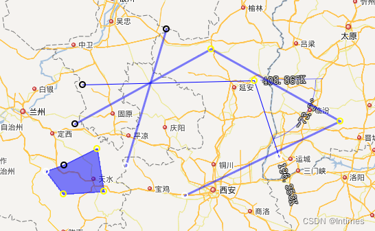
也就是说,只要更改经纬度和标记,就可以达到bln文件的效果。奥维是可以直接加载的。这个解决了matlab 2012a无法将线段输出成kml的问题。
边栏推荐
- Use JfreeChart to generate curves, histograms, pie charts, and distribution charts and display them to JSP-1
- Wechat forum exchange applet system graduation design (2) applet function
- Adrnoid开发系列(二十五):使用AlertDialog创建各种类型的对话框
- Innovation today | five key elements for enterprises to promote innovation
- 高级程序员必知必会,一文详解MySQL主从同步原理,推荐收藏
- Inftnews | the wide application of NFT technology and its existing problems
- Introduction to anomaly detection
- Network security - phishing
- One question per day - pat grade B 1002 questions
- 网络安全-联合查询注入
猜你喜欢
高级程序员必知必会,一文详解MySQL主从同步原理,推荐收藏

Wechat forum exchange applet system graduation design completion (7) Interim inspection report
微信论坛交流小程序系统毕业设计毕设(6)开题答辩PPT
微信论坛交流小程序系统毕业设计毕设(5)任务书

Wechat forum exchange applet system graduation design completion (8) graduation design thesis template
ArcGIS:字段赋值_属性表字段计算器(Field Calculator)依据条件为字段赋值

Cascade-LSTM: A Tree-Structured Neural Classifier for Detecting Misinformation Cascades-KDD2020
微信论坛交流小程序系统毕业设计毕设(4)开题报告

Unity3D学习笔记5——创建子Mesh
JMeter-接口自动化测试读取用例,执行并结果回写
随机推荐
Network security -burpsuit
微信论坛交流小程序系统毕业设计毕设(7)中期检查报告
微信论坛交流小程序系统毕业设计毕设(3)后台功能
Dynamics 365 find field filtering
Lecture 30 linear algebra Lecture 5 eigenvalues and eigenvectors
系统架构设计师备考经验分享:论文出题方向
Specific method example of V20 frequency converter manual automatic switching (local remote switching)
./ setup. Insufficient sh permission
Cascade-LSTM: A Tree-Structured Neural Classifier for Detecting Misinformation Cascades-KDD2020
Innovation today | five key elements for enterprises to promote innovation
Gee (III): calculate the correlation coefficient between two bands and the corresponding p value
About idea cannot find or load the main class
Coreseek:第二步建索引及測试
Transform XL translation
树后台数据存储(採用webmethod)[通俗易懂]
Matlab 信号处理【问答随笔·2】
网格(Grid)
Database daily question --- day 22: last login
UE4_UE5结合罗技手柄(F710)使用记录
Cases of agile innovation and transformation of consumer goods enterprises