当前位置:网站首页>Google Earth engine (GEE) -- 1975 dataset of Landsat global land survey
Google Earth engine (GEE) -- 1975 dataset of Landsat global land survey
2022-07-07 02:39:00 【This star is bright】
Recently, I found a giant cow's artificial intelligence learning website : Preface – A course of bed length artificial intelligence
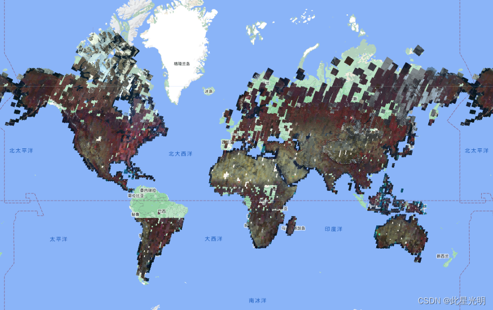
1975 Global land survey (GLS) Is from Landsat Multispectral scanner (MSS) Global image collection . Most scenes are composed of Landsat 1-3 stay 1972-1983 Obtained in .Landsat 1-3 Some blanks in the data have been Landsat 4-5 stay 1982-1987 Filled by the scenes acquired during the years . The data contains 4 A spectral band : green 、 Red 、NIR Band and SWIR Band . In a typical false color display , The image is displayed in red , Because it is displayed in red NIR The band highlights the vegetation .
Dataset availability
1972-07-25T00:00:00Z–1983-02-20T00:00:00( We can choose 1972-1983 All the effects of the year , You can also use this data NDVI Calculation , Other indexes cannot be calculated for the time being , Because there are few bands , Only 4 Band )
Data set provider
Earth engine fragment
ee.ImageCollection("LANDSAT/GLS1975")
The resolution of the
60 rice
Band : It is worth noting that there are only 4 Band , It's red 、 Happy color 、 Near infrared and short wave infrared bands ,
| full name | wavelength | describe |
|---|---|---|
10 | 500-600 nanometer | Green |
20 | 600-700 nanometer | Red |
30 | 700-800 nanometer | The near infrared |
40 | 800-1100 nanometer | Shortwave infrared |
Code :
var dataset = ee.ImageCollection('LANDSAT/GLS1975');
var falseColor = dataset.select(['30', '20', '10']);
var falseColorVis = {
  gamma: 1.6,
};
Map.setCenter(44.517, 25.998, 5);
Map.addLayer(falseColor, falseColorVis, 'False Color');
Terms of use
Landsat Datasets are data created by the federal government , Therefore, it is in the public domain , Can be used without copyright restrictions 、 Transfer or reproduction .
Confirmation or credit from the U.S. Geological Survey as a data source should be provided by including a line of text references , As shown below .
( product 、 Images 、 Photo or dataset name ) Provided by the United States Geological Survey
Example :Landsat-7 The picture is provided by the U.S. Geological Survey
About correct quotation and confirmation USGS More details about products , see also USGS Visual recognition system guide .
GLS 1975 The picture is provided by the U.S. Geological Survey
result
边栏推荐
- Common fitting models and application methods of PCL
- 【森城市】GIS数据漫谈(二)
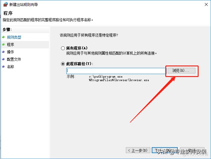
- Wireshark installation
- ODBC database connection of MFC windows programming [147] (with source code)
- Halcon实例转OpenCvSharp(C# OpenCV)实现--瓶口缺陷检测(附源码)
- Fundamentals of process management
- postgresql之integerset
- How do I dump SoapClient requests for debugging- How to dump SoapClient request for debug?
- Station B's June ranking list - feigua data up main growth ranking list (BiliBili platform) is released!
- Web3's need for law
猜你喜欢
Lumion 11.0 software installation package download and installation tutorial
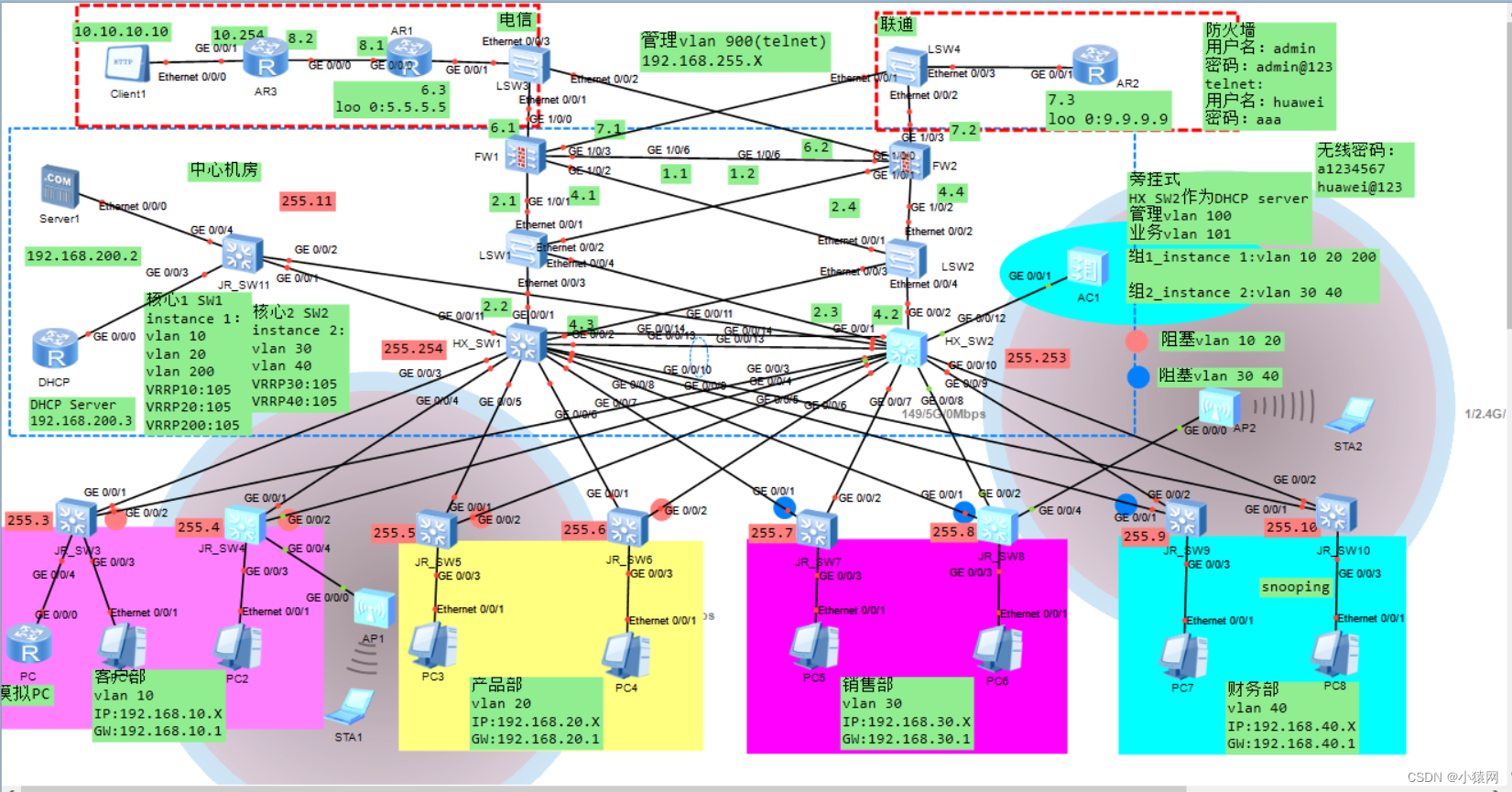
Planning and design of double click hot standby layer 2 network based on ENSP firewall
![[unity] upgraded version · Excel data analysis, automatically create corresponding C classes, automatically create scriptableobject generation classes, and automatically serialize asset files](/img/20/f7fc2204ca165dcea4af25cb054e9b.png)
[unity] upgraded version · Excel data analysis, automatically create corresponding C classes, automatically create scriptableobject generation classes, and automatically serialize asset files
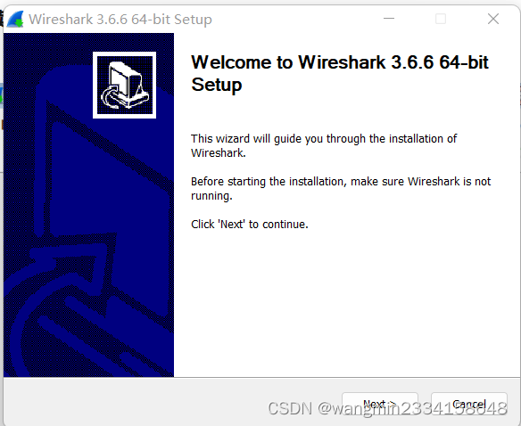
wireshark安装

【森城市】GIS数据漫谈(二)
如何设计好接口测试用例?教你几个小技巧,轻松稿定

本周 火火火火 的开源项目!
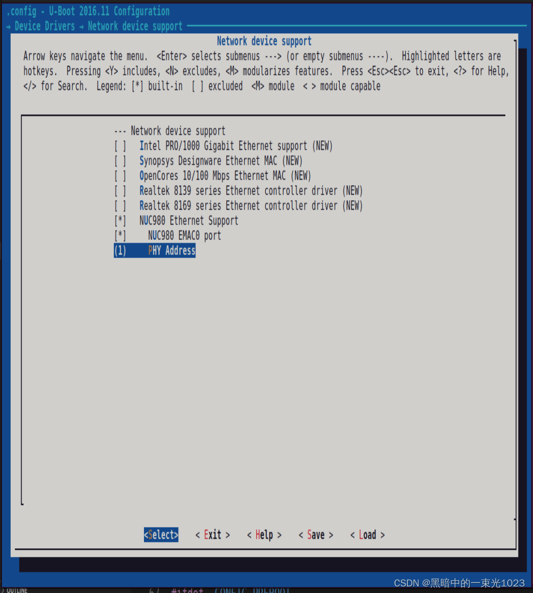
3--新唐nuc980 kernel支持jffs2, Jffs2文件系统制作, 内核挂载jffs2, uboot网口设置,uboot支持tftp
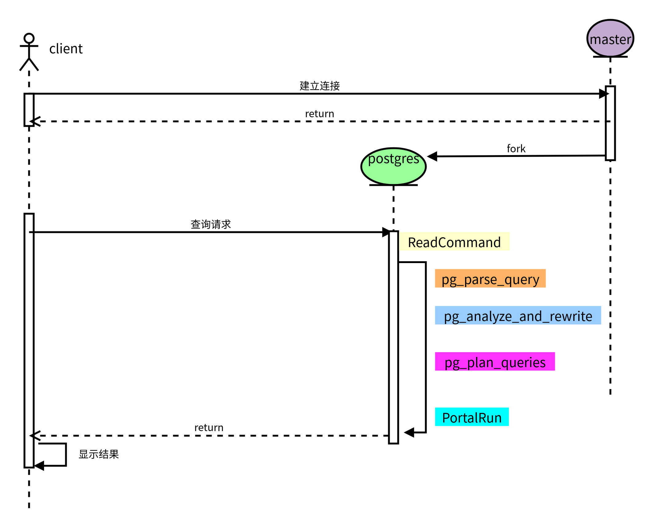
postgresql之整体查询大致过程

人脸识别应用解析
随机推荐
QT常见概念-1
【森城市】GIS数据漫谈(二)
postgresql之整體查詢大致過程
Leetcode:minimum_depth_of_binary_tree解决问题的方法
PCL 常用拟合模型及使用方法
MFC Windows 程序设计[147]之ODBC数据库连接(附源码)
Douban average 9 x. Five God books in the distributed field!
postgresql之integerset
数字滚动增加效果
AWS学习笔记(一)
差异与阵列和阵列结构和链表的区别
Increase 900w+ playback in 1 month! Summarize 2 new trends of top flow qiafan in station B
Detailed explanation of line segment tree (including tested code implementation)
本周 火火火火 的开源项目!
The panel floating with the mouse in unity can adapt to the size of text content
6-6 vulnerability exploitation SSH security defense
MATLB|具有储能的经济调度及机会约束和鲁棒优化
4--新唐nuc980 挂载initramfs nfs文件系统
如何从0到1构建32Core树莓派集群
NuScenes数据集关于Radar数据的统计