当前位置:网站首页>GPS原始坐标转百度地图坐标(纯C代码)
GPS原始坐标转百度地图坐标(纯C代码)
2022-07-05 14:37:00 【华为云】
一、环境介绍
GPS模块型号: 中科微电子GPS模块
GPS输出的原始数据帧:
$GNGGA,114955.000,2842.4158,N,11549.5439,E,1,05,3.8,54.8,M,0.0,M,,*4F$GNGLL,2842.4158,N,11549.5439,E,114955.000,A,A*4D$GPGSA,A,3,10,31,18,,,,,,,,,,5.7,3.8,4.2*37$BDGSA,A,3,07,10,,,,,,,,,,,5.7,3.8,4.2*2A$GPGSV,3,1,10,10,49,184,42,12,16,039,,14,54,341,,18,22,165,23*7B$GPGSV,3,2,10,22,11,318,,25,51,055,,26,24,205,,29,13,110,*7C$GPGSV,3,3,10,31,50,287,36,32,66,018,*7F$BDGSV,1,1,04,03,,,07,05,,,29,07,79,246,33,10,52,232,19*62$GNRMC,114955.000,A,2842.4158,N,11549.5439,E,0.00,44.25,061117,,,A*4D$GNVTG,44.25,T,,M,0.00,N,0.00,K,A*14$GNZDA,114955.000,06,11,2017,00,00*47$GPTXT,01,01,01,ANTENNA OK*35二、需求介绍
得到GPS原始坐标数据之后,想通过百度地图API接口直接显示实际定位。
国际经纬度坐标标准为WGS-84,国内必须至少使用国测局制定的GCJ- 02,对地理位置进行首次加密。
百度坐标在此基础上,进行了BD-09二次加密措施,更加保护了个人隐私。
百度对外接口的坐标系并不是GPS采集的真实经 纬度,需要通过坐标转换接口进行转换。
三、C语言代码
下面代码在QtCreator里编写,可以将代码移植到任何支持C语言的环境中编译运行。
#include <QCoreApplication>#include <QString>#include <QDebug>extern C;{#include <math.h>;}class GPS_Data{public: double lat; //纬度 double lng; //经度 QString GPS_Data;};class GPS_Data gps_data;void GPS_ReadUasrtData();#define M_PI 3.14159265358979324double a = 6378245.0;double ee = 0.00669342162296594323;double x_pi = M_PI * 3000.0 / 180.0;double wgs2gcj_lat(double x, double y){ double ret1 = -100.0 + 2.0 * x + 3.0 * y + 0.2 * y * y + 0.1 * x * y + 0.2 * sqrt(abs(x)); ret1 += (20.0 * sin(6.0 * x * M_PI) + 20.0 * sin(2.0 * x * M_PI)) * 2.0 / 3.0; ret1 += (20.0 * sin(y * M_PI) + 40.0 * sin(y / 3.0 * M_PI)) * 2.0 / 3.0; ret1 += (160.0 * sin(y / 12.0 * M_PI) + 320 * sin(y * M_PI / 30.0)) * 2.0 / 3.0; return ret1;}double wgs2gcj_lng(double x, double y){ double ret2 = 300.0 + x + 2.0 * y + 0.1 * x * x + 0.1 * x * y + 0.1 * sqrt(abs(x)); ret2 += (20.0 *sin(6.0 * x * M_PI) + 20.0 * sin(2.0 * x * M_PI)) * 2.0 / 3.0; ret2 += (20.0 * sin(x * M_PI) + 40.0 * sin(x / 3.0 * M_PI)) * 2.0 / 3.0; ret2 += (150.0 *sin(x / 12.0 * M_PI) + 300.0 * sin(x / 30.0 * M_PI)) * 2.0 / 3.0; return ret2;}void wgs2gcj(double *lat,double *lng){ double dLat = wgs2gcj_lat(*lng - 105.0, *lat - 35.0); double dLon = wgs2gcj_lng(*lng - 105.0, *lat - 35.0); double radLat = *lat / 180.0 * M_PI; double magic = sin(radLat); magic = 1 - ee * magic * magic; double sqrtMagic = sqrt(magic); dLat = (dLat * 180.0) / ((a * (1 - ee)) / (magic * sqrtMagic) * M_PI); dLon = (dLon * 180.0) / (a / sqrtMagic * cos(radLat) * M_PI); *lat = *lat + dLat; *lng = *lng + dLon;}void gcj2bd(double *lat,double *lng){ double x = *lng, y = *lat; double z = sqrt(x * x + y * y) + 0.00002 * sin(y * x_pi); double theta = atan2(y, x) + 0.000003 * cos(x * x_pi); *lng = z * cos(theta) + 0.0065; *lat = z * sin(theta) + 0.006;}int main(int argc, char *argv[]){ QCoreApplication a(argc, argv); GPS_ReadUasrtData(); //得到GPS原始坐标 double lat=gps_data.lat; double lng=gps_data.lng; //坐标转换 wgs2gcj(&lat,&lng); gcj2bd(&lat,&lng); //得到百度地图的坐标,可以直接在百度地图上显示 qDebug()<<"纬度: "<<QString("%1").arg(lat,0,'g',13); qDebug()<<"经度: "<<QString("%1").arg(lng,0,'g',13); return a.exec();}void GPS_ReadUasrtData(){ /*GPS的原始数据帧*/ gps_data.GPS_Data="$GNGGA,114955.000,2842.4158,N,11549.5439,E,1,05,3.8,54.8,M,0.0,M,,*4F" "$GNGLL,2842.4158,N,11549.5439,E,114955.000,A,A*4D" "$GPGSA,A,3,10,31,18,,,,,,,,,,5.7,3.8,4.2*37" "$BDGSA,A,3,07,10,,,,,,,,,,,5.7,3.8,4.2*2A" " $GPGSV,3,1,10,10,49,184,42,12,16,039,,14,54,341,,18,22,165,23*7B" "$GPGSV,3,2,10,22,11,318,,25,51,055,,26,24,205,,29,13,110,*7C" "$GPGSV,3,3,10,31,50,287,36,32,66,018,*7F" "$BDGSV,1,1,04,03,,,07,05,,,29,07,79,246,33,10,52,232,19*62" "$GNRMC,114955.000,A,2842.4158,N,11549.5439,E,0.00,44.25,061117,,,A*4D" "$GNVTG,44.25,T,,M,0.00,N,0.00,K,A*14" "$GNZDA,114955.000,06,11,2017,00,00*47" "$GPTXT,01,01,01,ANTENNA OK*35"; /*解析GPS模块的数据*/ //QString lat; //纬度 //QString lng; //经度 if(gps_data.GPS_Data.size()>200) { int index=gps_data.GPS_Data.indexOf("$GNGGA"); if(index>=0) { QString text=gps_data.GPS_Data.mid(index); if(text.size()>60) { QString lat=text.section(',',2,2); QString lng=text.section(',',4,4); if(lat.isEmpty()==false && lng.isEmpty()==false) { unsigned int int_data; double s_Longitude,s_latitude; //转换纬度 s_latitude=lat.toDouble(); s_latitude=s_latitude/100; int_data=s_latitude;//得到纬度整数部分 s_latitude=s_latitude-int_data;//得到纬度小数部分 s_latitude=(s_latitude)*100; gps_data.lat=int_data+(s_latitude/60.0); //得到转换后的值 //转换经度 s_Longitude=lng.toDouble(); s_Longitude=s_Longitude/100; int_data=s_Longitude;//得到经度整数部分 s_Longitude=s_Longitude-int_data; //得到经度小数部分 s_Longitude=s_Longitude*100; //gai guo le gps_data.lng=int_data+(s_Longitude/60.0); } } } gps_data.GPS_Data.clear(); }}边栏推荐
- ASP.NET大型外卖订餐系统源码 (PC版+手机版+商户版)
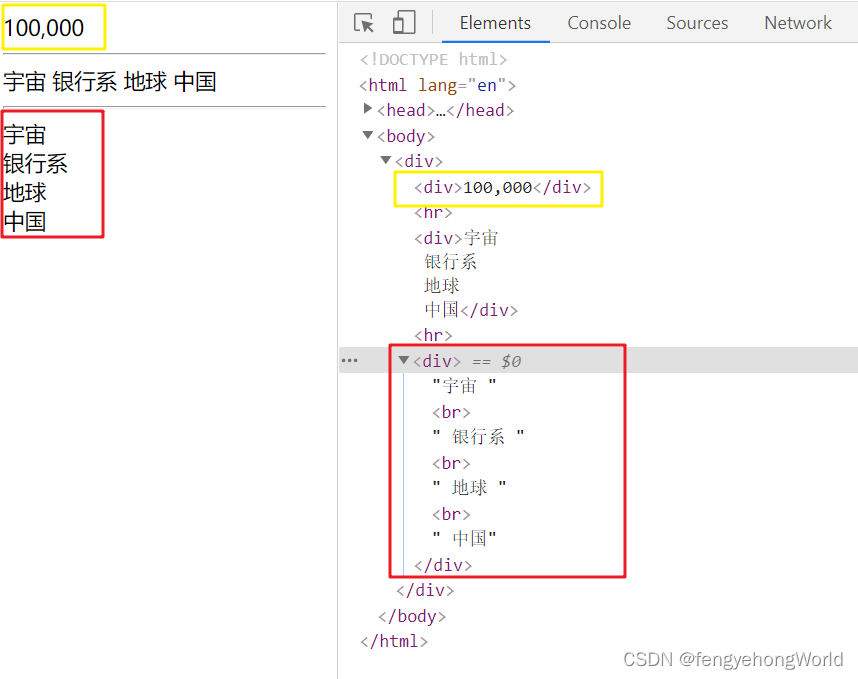
- Thymeleaf th:with use of local variables
- [learning notes] stage test 1
- 基于TI DRV10970驱动直流无刷电机
- Matrix chain multiplication dynamic programming example
- 实现一个博客系统----使用模板引擎技术
- 分享 12 个最常用的正则表达式,能解决你大部分问题
- 【NVMe2.0b 14-9】NVMe SR-IOV
- Long list optimized virtual scrolling
- Under the crisis of enterprise development, is digital transformation the future savior of enterprises
猜你喜欢

Photoshop插件-动作相关概念-ActionList-ActionDescriptor-ActionList-动作执行加载调用删除-PS插件开发

Chow Tai Fook fulfills the "centenary commitment" and sincerely serves to promote green environmental protection
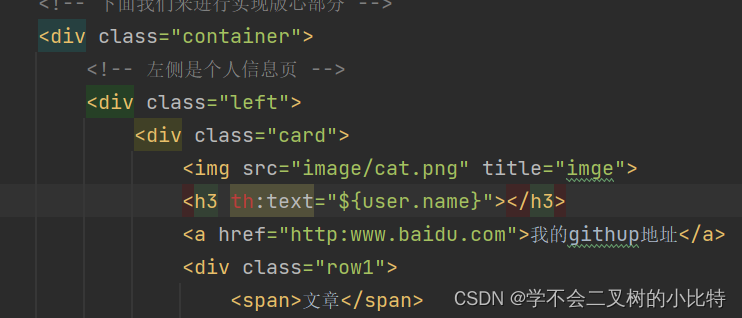
Implement a blog system -- using template engine technology
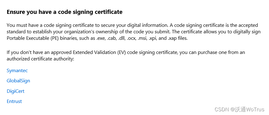
申请代码签名证书时如何选择合适的证书品牌?

危机重重下的企业发展,数字化转型到底是不是企业未来救星

CyCa children's physical etiquette Ningbo training results assessment came to a successful conclusion
World Environment Day | Chow Tai Fook serves wholeheartedly to promote carbon reduction and environmental protection
Thymeleaf 使用后台自定义工具类处理文本
【学习笔记】阶段测试1

家用电器行业商业供应链协同平台解决方案:供应链系统管理精益化,助推企业智造升级
随机推荐
Thymeleaf th:classappend attribute append th:styleappend style append th:data- custom attribute
be careful! Software supply chain security challenges continue to escalate
Thymeleaf th:with局部变量的使用
日化用品行业智能供应链协同系统解决方案:数智化SCM供应链,为企业转型“加速度”
实现一个博客系统----使用模板引擎技术
Change multiple file names with one click
CYCA少儿形体礼仪 宁波市培训成果考核圆满落幕
【学习笔记】图的连通性与回路
01. Solr7.3.1 deployment and configuration of jetty under win10 platform
FR练习题目---简单题
面试突击62:group by 有哪些注意事项?
Sharing the 12 most commonly used regular expressions can solve most of your problems
超级哇塞的快排,你值得学会!
无密码身份验证如何保障用户隐私安全?
Countermeasures of enterprise supply chain management system in UCA Era
【NVMe2.0b 14-9】NVMe SR-IOV
分享 12 个最常用的正则表达式,能解决你大部分问题
C language -- structure and function
Pointer operation - C language
How to protect user privacy without password authentication?