当前位置:网站首页>Google Earth engine (GEE) - globfire daily fire data set based on mcd64a1
Google Earth engine (GEE) - globfire daily fire data set based on mcd64a1
2022-07-04 22:47:00 【This star is bright】
be based on MODIS Data sets MCD64A1 Fire boundary of . The data is calculated based on an algorithm , The algorithm relies on encoding the space-time relationship between patches of burned out regions in the graphic structure .
Each fire has a unique number to identify the event .
Dataset Availability
2001-01-01T00:00:00Z–2021-01-01T00:00:00
Dataset Provider
European Commission, Joint Research Centre, Global Wildfire Information System
The data call :
'JRC/GWIS/GlobFire/v2/DailyPerimeters'
Code :
// Call... Directly from the folder , Nothing here featurecollection.
var folder = 'JRC/GWIS/GlobFire/v2/DailyPerimeters';
// Use... With asynchronous callbacks ee.data.listAssets List available tables .
function printAssetList(listAssetsOutput) {
print('Asset list:', listAssetsOutput['assets']);
}
ee.data.listAssets(folder, {}, printAssetList);
// Define a table name from the list of available tables ( surface ID).
var tableName = 'JRC/GWIS/GlobFire/v2/DailyPerimeters/2020';
var computeArea = function (f) {
return f.set({'area': f.area()});
}
// Import a selected table as a feature set .
var features = ee.FeatureCollection(tableName).map(computeArea);
// Visual parameters of linear fire area gradient .
var visParams = {
palette: ['f5ff64', 'b5ffb4', 'beeaff', 'ffc0e8', '8e8dff', 'adadad'],
min: 0.0,
max: 600000000.0,
opacity: 0.8,
};
// Use the calculated fire area as the numerical attribute , Draw the fire perimeter on the image .
var image = ee.Image().float().paint(features, 'area')
// Display the image on the map ( Including features explored by inspectors ).
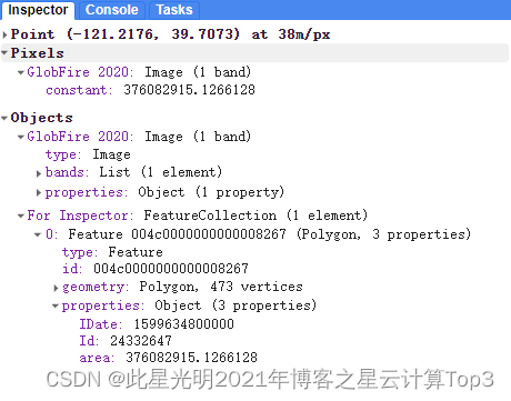
Map.addLayer(image, visParams, 'GlobFire 2020');
Map.addLayer(features, null, 'For Inspector', false);
Map.setCenter(-121.23, 39.7, 12);Terms of Use
Licensed under the Creative Commons Attribution 4.0 International License.
Citations:
Artés, T., Oom, D., De Rigo, D., Durrant, T. H., Maianti, P., Libertà, G., & San-Miguel-Ayanz, J. (2019). A global wildfire dataset for the analysis of fire regimes and fire behaviour. Scientific data, 6(1), 1-11. doi:10.1038/s41597-019-0312-2
result :
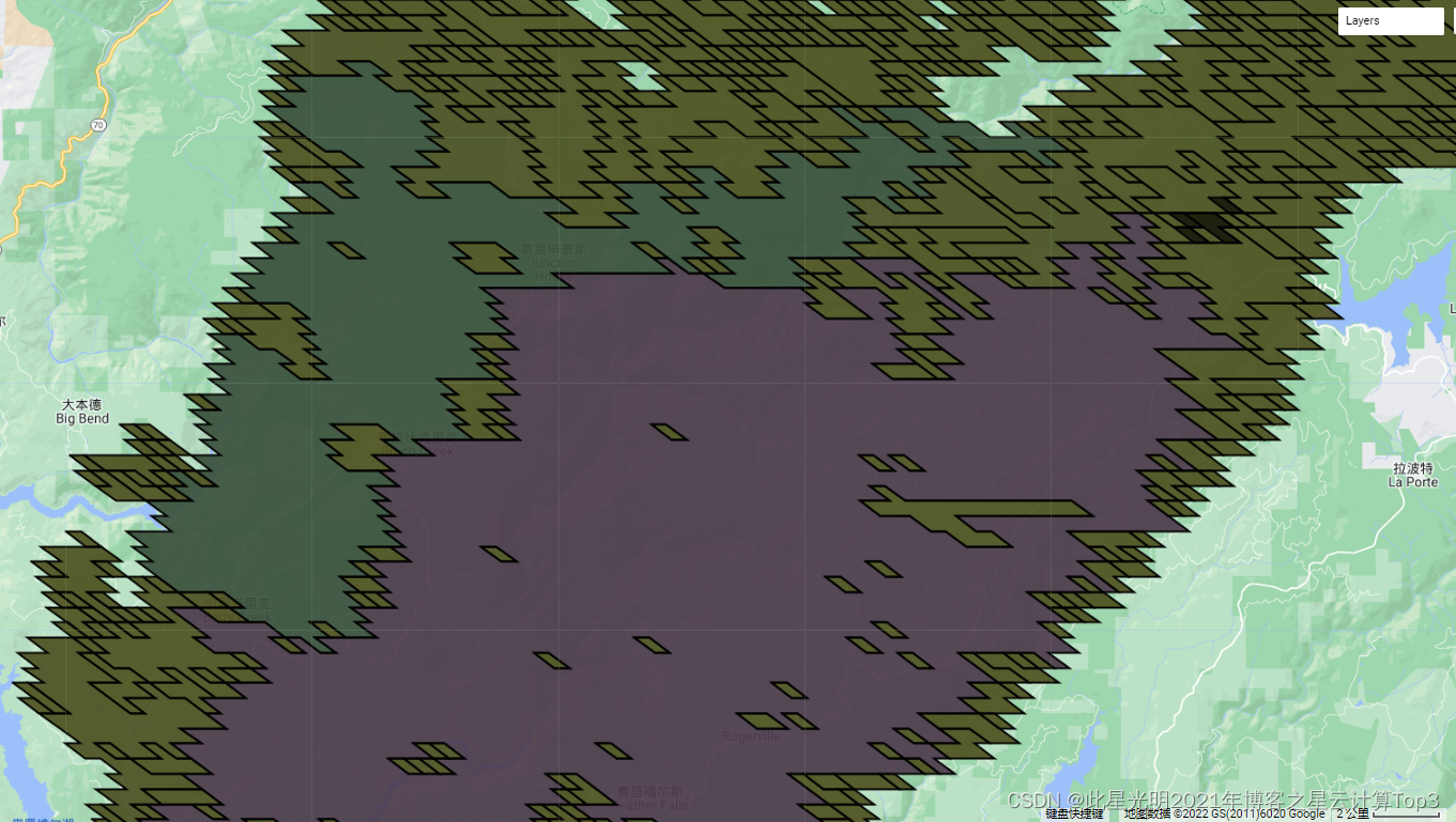
Fire display of different levels :
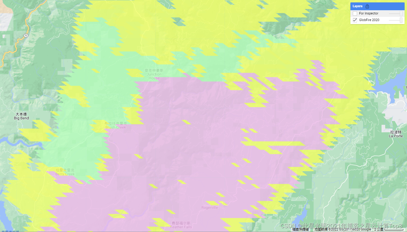
Click to view the corresponding information, fire area, etc
边栏推荐
- Easy to use app recommendation: scan QR code, scan barcode and view history
- 共创软硬件协同生态:Graphcore IPU与百度飞桨的“联合提交”亮相MLPerf
- Alibaba launched a new brand "Lingyang" and is committed to becoming a "digital leader"
- md5工具类
- Unity vscode emmylua configuration error resolution
- Advanced area a of attack and defense world misc Masters_ good_ idea
- Jvm-Sandbox-Repeater的部署
- Logo special training camp Section V font structure and common design techniques
- Concurrent network modular reading notes transfer
- 剑指 Offer 68 - I. 二叉搜索树的最近公共祖先
猜你喜欢
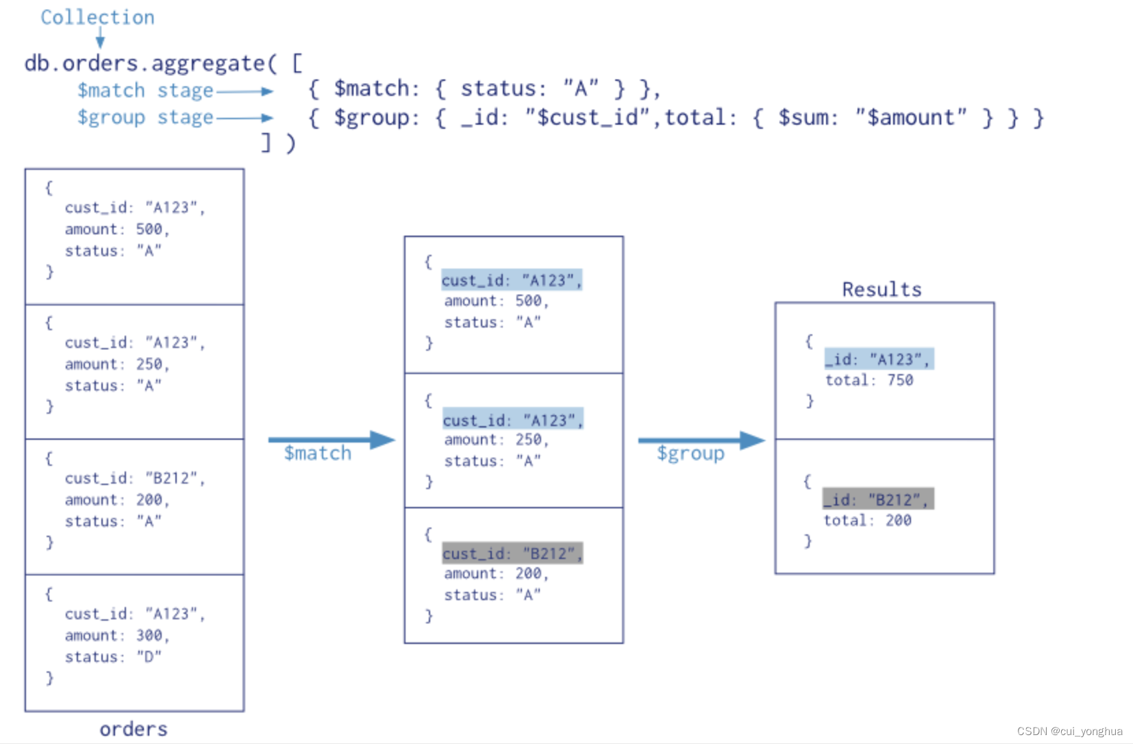
Mongodb aggregation operation summary

NFT Insider #64:电商巨头eBay提交NFT相关商标申请,毕马威将在Web3和元宇宙中投入3000万美元

sobel过滤器
Domestic database chaos
Concurrent optimization summary

LOGO特训营 第五节 字体结构与设计常用技法
Detailed explanation of heap sort code
UML diagram memory skills
The overview and definition of clusters can be seen at a glance
Attack and defense world misc advanced area can_ has_ stdio?
随机推荐
【室友用一局王者荣耀的时间学会了用BI报表数据处理】
Recommendation of mobile app for making barcode
Logo special training camp Section IV importance of font design
idea中pom.xml依赖无法导入
Embedded development: skills and tricks -- seven skills to improve the quality of embedded software code
Google Earth engine (GEE) -- take modis/006/mcd19a2 as an example to batch download the daily mean, maximum, minimum, standard deviation, statistical analysis of variance and CSV download of daily AOD
串口数据帧
2022-07-04:以下go语言代码输出什么?A:true;B:false;C:编译错误。 package main import “fmt“ func main() { fmt.Pri
Alibaba launched a new brand "Lingyang" and is committed to becoming a "digital leader"
安装人大金仓数据库
LOGO特训营 第五节 字体结构与设计常用技法
Flask 上下文详解
NFT insider 64: e-commerce giant eBay submitted an NFT related trademark application, and KPMG will invest $30million in Web3 and metauniverse
Shell script implements application service log warehousing MySQL
Challenges faced by virtual human industry
面试必备 LeetCode 链表算法题汇总,全程干货!
MySQL storage data encryption
SPSS安装激活教程(包含网盘链接)
NFT Insider #64:电商巨头eBay提交NFT相关商标申请,毕马威将在Web3和元宇宙中投入3000万美元
【lua】int64的支持