当前位置:网站首页>[Mori city] random talk on GIS data (I)
[Mori city] random talk on GIS data (I)
2022-07-04 07:04:00 【ThingJS_ Xiaoli】
Recently, a little partner raised some questions about GIS Data problems :
problem 1: Can the water system map be uploaded to Sen map for use ? At present, the format types supported by the exported water system map are :xml、cpg、shx、shp、sbx、prj、sbn、dbf.
problem 2: I made orthophoto images of my modeling area , Can it be imported into the map as part of the tile ?
The above questions are related to GIS Data related issues , To solve these problems, we first need to understand what is GIS?GIS What is the difference between data formats ?
What is? GIS?
Geographic Information System (Geographic Information System or Geo-Information system,GIS) Sometimes called “ Geoscience information system ”. It is a special and very important spatial information system . It's hard in the computer 、 With the support of software system , To the whole or part of the earth's surface ( Including the atmosphere ) Collect the relevant geographic distribution data in space 、 Store 、 management 、 operation 、 analysis 、 Display and description of the technical system .
Modern human behavior and position are closely related , Whether it's sending and receiving express or catering takeout, it's inseparable from location information .GIS It's a comprehensive subject , Combining Geography with cartography, remote sensing and Computer Science , Widely used in different fields . Help us make better use of spatial data to combine with other industry technologies , Carry out powerful auxiliary decision-making and management applications .
Vector data and grid data
GIS There are many ways to classify data , One of the most basic classification methods is also the data structure that we often come into contact with ( Or data model ) You can put GIS The data is divided into vector data and raster data .

vector data
Definition : With x、y Space points represented by coordinates or coordinate strings 、 Line 、 The general name of graphic data such as faces and related attribute data .
describe : For point entities , The vector structure only records its coordinates and attribute codes in a specific coordinate system ; For line entities , It is represented by the line of a series of coordinate pairs ; For face entities , That's polygons , Express the line with a series of closed coordinates . Vector mode is helpful to describe some discrete features , But for the characteristics of continuous change , For example, soil 、 terrain 、 Mines, etc. are not applicable .
raster data
Definition : Grid data structure is the use of regular grids to divide geographical space , Form geographical cover . Each spatial object is mapped to the corresponding geographical grid according to its geographical location , The identification or type of spatial objects contained in each grid record .
describe : Grid structure is the simplest and most direct spatial data structure , It uses regular arrays to represent the data organization of spatial feature or phenomenon distribution , Each data in the organization represents the non geometric attributes of a feature or phenomenon . In raster data , Points are represented by a grid cell ; The line is marked by a group of adjacent grid cells along the line , Each grid cell has at most two adjacent cells on the line ; The surface is represented by a set of adjacent grid cells with regional attributes , Each grid cell can have more than two adjacent cells belonging to the same area .
vector 、 Grid data file
Vector data file
The main common data formats of vector data files are :ShapeFile、GeoJSON、TopoJSON、WKB/WKT(Well-known text)、KML/KMZ. Among them, the most common in actual projects GIS The format of vector data file is ShapeFile and GeoJSON.
ShapeFile
ShapeFile( Also abbreviated as shp) Is a collection of files , As shown in the figure below, the railway line data is composed of many files with different suffixes . The advantage is good compatibility 、 Widely applied , But from data sharing 、 From the perspective of transmission, it can not meet the needs of network transmission of shared data in the Internet era , That's why later GeoJSON File format .

GeoJSON
GeoJSON Yes, it is JSON Syntax for expressing and storing geographic data , about Web applications ,GeoJSON It is the most widely used data format .GeoJSON The following geometry types are supported : spot 、 Line 、 Noodles 、 Multipoint 、 Multi line 、 Polyhedra and geometric sets .

It can be seen that ,GeoJSON It is used in 、 Line 、 Face to represent geographical objects , And spatial data ( Or geometric fields )Geometry There are corresponding points stored in 、 Line 、 Face coordinates . This is the characteristic of vector data , Ready to use 、 Line 、 Surface to represent the geometric characteristics of geographical objects .
problem 1 The solution is : Sen city supports GeoJSON Data upload , So just put Shapefile The file is converted to GeoJSON After uploading the file to Mori City, you can use .

Grid data file
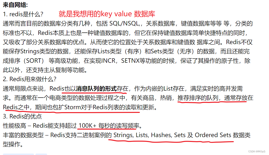
For all of you , common GIS Grid data is remote sensing image ( Satellite imagery / Satellite photos ), More broadly, various aerial images ( Photo ) It's all raster data .GIS Data or spatial analysis of some remote sensing applications 、 The calculation result data will generally be provided in the form of grid data , The size of raster data is directly proportional to the spatial range and resolution of the data . Simply put, the larger the scope , The higher the resolution , The larger the amount of data .

So generally, these data will not be uploaded directly to Web End treatment , But the use of GIS Software or other tools make data into map tiles ( section ) Then it will be published as a map service , Re supply Web Front end application display .
The solution to problem two is : Make orthophoto into map tiles ( section ) After publishing as a map service , Then configure the map tile service address to use .
Tool recommendation
Mori City : One click generation 3D City , Built in multiple templates , Free editing
• Mori city currently provides nationwide 110 Multiple cities Standard 3D scene construction service , Make the construction speed of urban 3D scene increase to minute level .
• Sen city supports the insertion and automatic fusion of different types of city data , And provide friendly and powerful scene editing ability and performance processing ability , Not required GIS、 Modeling and other professional skills , It's easy DIY Own cool 3D city scene .
• Mori city has open City scene output capability , There is no need to worry about the compatibility of subsequent use of the scene .
Scan the code and follow the official official account - Get the latest information
边栏推荐
- About how idea sets up shortcut key sets
- NLP literature reading summary
- 2022年,或许是未来10年经济最好的一年,2022年你毕业了吗?毕业后是怎么计划的?
- Tar source code analysis Part 3
- Campus network problems
- Shopping malls, storerooms, flat display, user-defined maps can also be played like this!
- NLP-文献阅读总结
- MySQL 45 learning notes (XI) how to index string fields
- 2022 is probably the best year for the economy in the next 10 years. Did you graduate in 2022? What is the plan after graduation?
- Boast about Devops
猜你喜欢

Pangu open source: multi support and promotion, the wave of chip industry
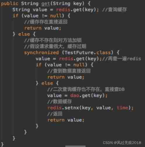
Redis - detailed explanation of cache avalanche, cache penetration and cache breakdown
What is the use of cloud redis? How to use cloud redis?
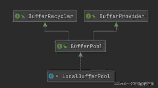
Flink memory model, network buffer, memory tuning, troubleshooting
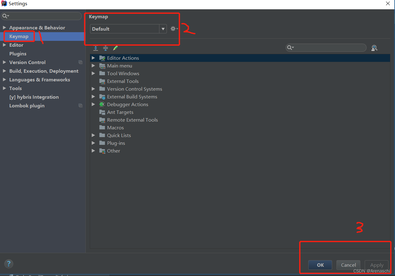
About how idea sets up shortcut key sets

NLP-文献阅读总结
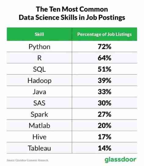
List of top ten professional skills required for data science work
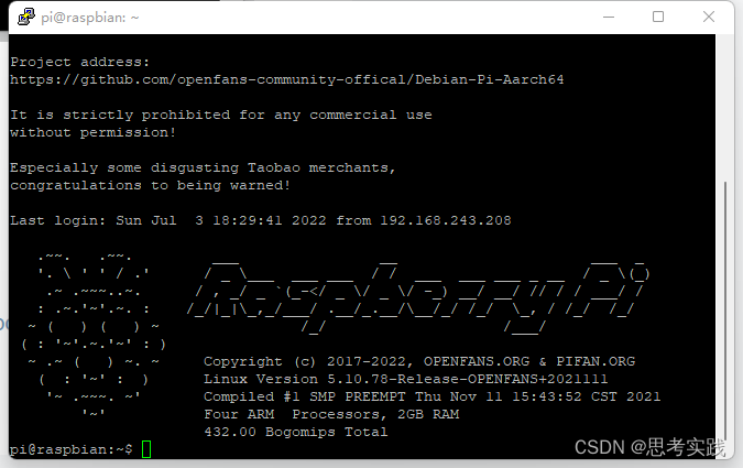
Computer connects raspberry pie remotely through putty
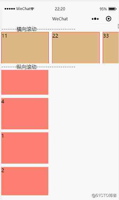
Wechat applet scroll view component scrollable view area

Su Weijie, a member of Qingyuan Association and an assistant professor at the University of Pennsylvania, won the first Siam Youth Award for data science, focusing on privacy data protection, etc
随机推荐
Su Weijie, a member of Qingyuan Association and an assistant professor at the University of Pennsylvania, won the first Siam Youth Award for data science, focusing on privacy data protection, etc
响应式移动Web测试题
List of top ten professional skills required for data science work
Tar source code analysis Part 7
Highly paid programmers & interview questions: how does redis of series 119 realize distributed locks?
高薪程序员&面试题精讲系列119之Redis如何实现分布式锁?
Vulhub vulnerability recurrence 76_ XXL-JOB
[thread pool]
Design of test cases
Redis interview question set
图的底部问题
Data double write consistency between redis and MySQL
com. alibaba. nacos. api. exception. NacosException
Analysis of tars source code 1
About how idea sets up shortcut key sets
校园网络问题
电子协会 C语言 1级 35 、银行利息
How can the old version of commonly used SQL be migrated to the new version?
Explain in one sentence what social proof is
How to share the source code anti disclosure scheme