当前位置:网站首页>Digital twins help visualize the construction of smart cities
Digital twins help visualize the construction of smart cities
2022-08-02 23:32:00 【digital twin family】
Smart city is an important starting point to promote the modernization of urban governance system and governance capacity.At the national level, the "14th Five-Year Plan" clearly states that it is necessary to explore the construction of digital twin cities, which points out the direction for the construction of domestic smart cities.In this context, a group of domestic digital twin technology companies represented by Zhihui Yunzhou, combined with years of practical experience, put forward a space-time visualization application scheme for smart cities.

Smart city spatiotemporal visualization construction,
With its leading technology foundation, Zhihui Yunzhou continues to help the digital transformation of cities, and promote the digital upgrade of industrial collaboration.The company has participated in the construction of many key projects successively, and the application fields include smart city, smart park, digital village, industrial manufacturing, rail transit, military industry, Xueliang project (safe city), judicial supervision, emergency command, schools, hospitals, water conservancy, electricity, etc.Industry-wide scenarios.
1. Building a digital twin city
Zhihui Yunzhou's urban spatiotemporal visualization application platform, with 3D geographic information system (3DGIS) as the core engine, integrates multi-source data such as remote sensing images, digital elevation, electronic maps and 3D urban models to reconstruct 3D virtual geography of citiessurroundings.In the virtual city scene, according to the real and precise coordinate position of the urban space such as longitude, latitude, altitude, etc., unstructured big data such as real-time video, intelligent analysis data and IoT perception data are integrated to construct the real world into a virtual three-dimensional digital image.Twin cities, the first stage of realizing urban spatiotemporal situational awareness, visual visualization situational awareness.

2. Intelligent application based on spatial location
Digital twin geographic coordinates are a pervasive part of our planet, and in a digital world, the only way to create a "digital twin" is to leverage location.Traditional intelligent analysis applications are based on a single video or a single scene. There is no overall and global concept, and any single situation or state cannot be called a situation.When understanding the situation, special emphasis should be placed on contextual, dynamic and holistic.Zhihui Yunzhou smart city spatiotemporal visualization application platform is based on AI (artificial intelligence) + LI (location intelligence) as the intelligent application engine, which enables artificial intelligence applications based on a single video and a single scene, combined with spatial location, to achieve a more realistic,More accurate mining and analysis will be more meaningful.
LI (Location Intelligence) location intelligence, digital twin is derived from the development of traditional GIS applications, but it is not limited to GIS applications.Traditional GIS is a departmental, small-scale application, mainly used in specialized fields such as surveying and mapping, geological exploration, and its solutions are mostly tools to help customers achieve local applications.And "location intelligence" emphasizes the combination of location information and data information to help managers make correct decisions.

Smart city space-time visualization construction
Location intelligence is an extension and supplement to artificial intelligence. A digital twin uses location-related information in its operating environment and external factors to combine relevant data, business services and professional experience to achieve measurement and comparison., visualize, analyze, and take action with predictions, digital twins support business operations.Simply put, digital twin location intelligence is to superimpose and combine location information and data information to visualize business information and help managers make correct decisions quickly.
Through location intelligence, a variety of perception data in the real city can be mined and analyzed in time + space in the twin city scene, and visualized understanding and expression can be realized, forming the second urban space-time situational awareness.Stage, digital twin space visualization situation understanding.

Smart city space-time visualization construction
3. Visual prediction of city business
Digital twin city business visualization situation prediction is the third stage of urban spatiotemporal situational awareness, which directly guides and supports decision analysis and action strategies.In the construction of digital twin cities, the value of location intelligence is mainly reflected in four aspects: positioning, visualization, analysis and planning.Zhihui Yunzhou spatio-temporal situational awareness application platform, driven by AI (artificial intelligence) + LI (location intelligence), first locates urban data and associates data with location, which is the basis for decision-making;Visualization, the digital twin finds location-related information, visualizes the location information data to perform more and more complex location-based operations; conducts location-based data in-depth mining analysis again, and improves the application to the analysis level, such as variousBy adding these data to business data, the digital twin provides richer data support for urban management and decision-making; finally, urban spatial intelligent planning is carried out, that is, based on location intelligenceAnalysis, combined with various databases of people, vehicles, places, objects and groups in the city, such as household registration, credit information, social security, traffic, face and other databases, to realize the perception, understanding, prediction analysis and situation simulation application of various businesses in the city brain,And through the visual and intuitive expression of the digital twin city, it supports the accurate decision-making and business application planning of the city management department.
边栏推荐
猜你喜欢
Redis 5 种数据结构及对应使用场景

Meta 与苹果的元宇宙碰撞
"A daily practice, happy water problem" 1374. Generate a string with an odd number of each character
9,共模抑制比一-不受输入信号中共模波动的影响。【如何分析共模CM抑制比。】
SQL Server实现group_concat功能
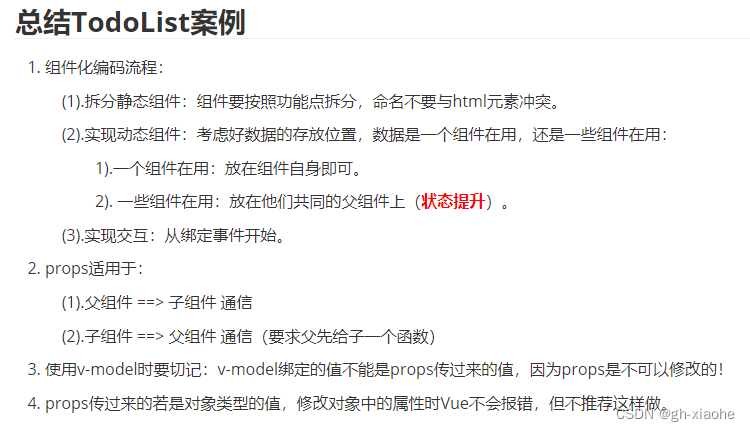
TodoList案例
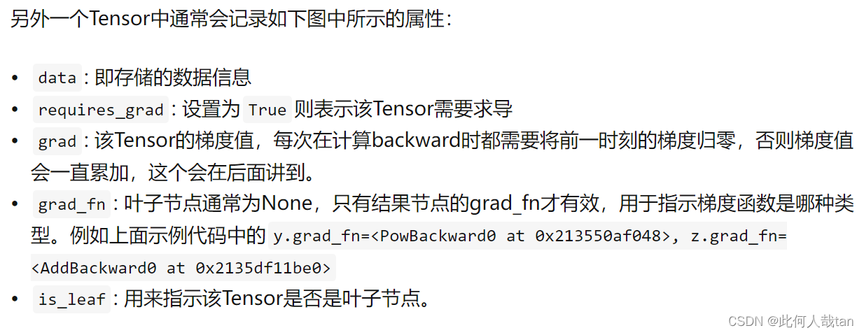
pytorch的tensor创建和操作记录

信息学奥赛一本通(1259:【例9.3】求最长不下降序列)
OP analysis and design
特拉维夫大学 | Efficient Long-Text Understanding with Short-Text Models(使用短文本模型进行高效的长文本理解)
随机推荐
如何解决图像分类中的类别不均衡问题?不妨试试分开学习表征和分类器
软件成分分析:华为云重磅发布开源软件治理服务
【软件工程导论】软件工程导论笔记
SQL 入门之第一讲——MySQL 8.0.29安装教程(windows 64位)
4 kmiles join YiSheng group, with more strong ability of digital business, accelerate China's cross-border electricity full domain full growth
程序员也许都缺一个“二舅”精神
信息系统项目管理师必背核心考点(五十八)变更管理的主要角色
网络协议介绍
六石管理学:入门机会只有一次,先把产品做好
The so-called fighting skill again gao also afraid of the chopper - partition, depots, table, and the merits of the distributed
TPAMI2022 | TransCL:基于Transformer的压缩学习,更灵活更强大
EasyExcel dynamic parsing and save table columns
有效解决MySQL报错:ERROR 1045 (28000): Access denied for user ‘root‘@‘localhost‘ (using password: NO/YES)
arm64麒麟安装paddlehub(国产化)
信息学奥赛一本通(1256:献给阿尔吉侬的花束)
golang source code analysis: uber-go/ratelimit
Axure9的元件用法
美国爱荷华州立大学| Improving Distantly Supervised Relation Extraction by Natural Language Inference(通过自然语言推理改进远程监督关系提取)
Lvm逻辑卷
笑话:如果你在河边等待得足够久,你会看到你的敌人的尸体漂过,是怎么翻译出来的?