当前位置:网站首页>Urban land use distribution data / urban functional zoning distribution data / urban POI points of interest / vegetation type distribution
Urban land use distribution data / urban functional zoning distribution data / urban POI points of interest / vegetation type distribution
2022-07-08 01:38:00 【Geographic remote sensing ecological network】
Sample data : Baidu cloud download link :https://pan.baidu.com/s/17ofPwpDM3OCHnE-LuhvUp Extraction code :i0m4
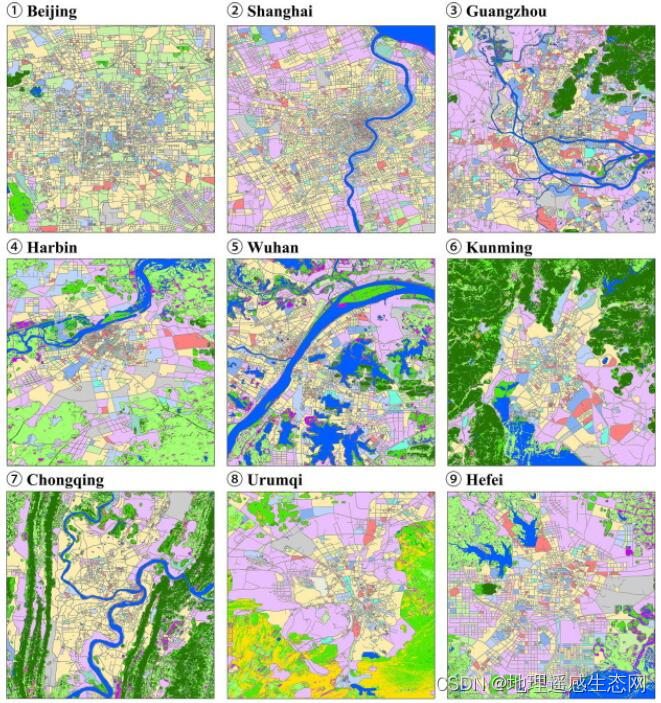
Urban functional zoning is to divide various material elements in the city according to functional requirements , Like a factory 、 Warehouse 、 Partition layout of residential buildings , Form an interconnected 、 An organic whole with reasonable layout , Create a good environment and conditions for various activities in the city . According to the principle of functional zoning, the form of land use and spatial layout is Urban master plan An important way to solve this problem .
at present Geographic remote sensing ecological network platform The distribution data of urban functional zoning has been released .
In modern urban planning , Functional zoning is usually evaluated 、 Based on the selection of urban land ( See urban land evaluation ). Generally, cities have the following main functional areas : Residential area 、 industrial area 、 Warehouse area 、 External traffic area, etc ; Some cities also have administrative districts 、 business zone 、 Cultural and educational District 、 Recuperation area, etc . The division of urban functional areas does not mean mechanically 、 Absolutely divide urban land . for example , The residential area is mainly equipped with various housing buildings and Living service facilities , But it can also be arranged without polluting the environment , the volume of freight transport Small industrial enterprises ; The industrial area is mainly equipped with factories and related power 、 Warehouse 、 Transportation and other facilities , But it is also necessary to set up some living service facilities , And some scientific research institutions . As for the municipal administrative and economic institutions 、 Institutions of higher learning 、 Scientific research and design institutions 、 Large sports facilities , Generally, it can be relatively concentrated in independent areas or sections , Some can also be arranged in residential areas .
Geographic remote sensing ecological network platform The national urban function zoning distribution data released , By using 2018 Year of 10 M satellite image (Sentinel-2A/B )、OpenStreetMap、 Night lighting ( Luojia one )、POI ( Gould map ,POI Category and quantity of ) Communicate with Tencent big data ( Tencent location big data ) As an input feature , Mark each plot 5 There are three main function labels and 12 Subcategory labels . Training and validation samples are collected separately through crowdsourcing , involve 27 Selected representative cities 21 A research group .
Four types of features are used in land use classification . The first comes from 10 rice Sentinel-2A/B Images ( That's blue 、 green 、 Mean and standard deviation of red and near infrared bands 、 Normalized vegetation index and normalized water index ). The second type is the location request from Tencent mobile (MPL) data ( That is, the active population on weekdays and weekends 8 Hourly average trajectory ) From . The third is 130 Miroja-1 night light image ( That is, the numerical average ). The fourth is Gaode POI data ( That is, the total number of all points of interest , And the total number and proportion of each interest point in each plot ). By extracting features of the training block , Using random forests (RF) The classifier generates the distribution data of national urban functional zoning .
Class A | second level | explain |
01 residential | 0101 residential | Houses and apartment buildings —— Where people live . |
02 business | 0201 Business office | Buildings where people work , Including office buildings , And finance 、 Internet technology 、 Electronic Commerce 、 Commercial office space such as media . |
0202 Business services | For commercial retail 、 The restaurant 、 Houses and buildings for accommodation and entertainment . | |
03 Industry | 0301 Industry | Used to make 、 Warehouse 、 Land and buildings for mining, etc . |
04 traffic | 0401 road | Paved road , Including highways 、 Major and minor urban roads . |
0402 Transportation station | Transportation facilities include cars 、 The bus 、 Train stains and ancillary facilities . | |
0403 Airport facilities | civil 、 Military and mixed use airports . | |
05 Public administration and services | 0501 Administration | For the government 、 Land for the army and public services . |
0502 education | Land for education and research , Including schools 、 university 、 The Institute and its ancillary facilities . | |
0503 Medical care | For hospitals 、 Land for disease prevention and emergency services . | |
0504 Sports and culture | For public sports training 、 Land for Cultural Services , Including the fitness center 、 The library 、 The museum 、 Exhibition Center, etc . | |
0505 Parks and green spaces | Parks and green spaces for entertainment and environmental protection . |
Hurry to pay attention for three times , The data acquisition method is as follows :

边栏推荐
- 2022 safety officer-c certificate examination paper and safety officer-c certificate simulated examination question bank
- 城市土地利用分布数据/城市功能区划分布数据/城市poi感兴趣点/植被类型分布
- About how USRP sets the sampling frequency below the minimum sampling frequency reached by the hardware
- 4. Strategic Learning
- About snake equation (3)
- Blue Bridge Cup embedded (F103) -1 STM32 clock operation and led operation method
- 项目经理有必要考NPDP吗?我告诉你答案
- Scalar / vector / matrix derivation method
- 生态 | 湖仓一体的优选:GBase 8a MPP + XEOS
- Tapdata 的 2.0 版 ,開源的 Live Data Platform 現已發布
猜你喜欢

5. Contrôle discret et contrôle continu
Application of state mode in JSF source code
Kindle operation: transfer downloaded books and change book cover

从Starfish OS持续对SFO的通缩消耗,长远看SFO的价值
LeetCode 练习——剑指 Offer 36. 二叉搜索树与双向链表
5、離散控制與連續控制
3. Multi agent reinforcement learning
3、多智能体强化学习
Redis cluster
Transportation, new infrastructure and smart highway
随机推荐
ANSI / NEMA- MW- 1000-2020 磁铁线标准。. 最新原版
The solution of frame dropping problem in gnuradio OFDM operation
FIR filter of IQ signal after AD phase discrimination
城市土地利用分布数据/城市功能区划分布数据/城市poi感兴趣点/植被类型分布
Chapter improvement of clock -- multi-purpose signal modulation generation system based on ambient optical signal detection and custom signal rules
Micro rabbit gets a field of API interface JSON
After modifying the background of jupyter notebook and adding jupyterthemes, enter 'JT -l' and the error 'JT' is not an internal or external command, nor a runnable program
LeetCode 练习——剑指 Offer 36. 二叉搜索树与双向链表
The usage of rand function in MATLAB
Continued from the previous design
Js中forEach map无法跳出循环问题以及forEach会不会修改原数组
2022 tea master (intermediate) examination questions and tea master (intermediate) examination skills
快速熟知XML解析
小金额炒股,在手机上开户安全吗?
How to get the first and last days of a given month
Solve the error: NPM warn config global ` --global`, `--local` are deprecated Use `--location=global` instead.
Overall introduction of the project
npm 内部拆分模块
3. Multi agent reinforcement learning
Redis集群