当前位置:网站首页>Description of longitude and latitude PLT file format
Description of longitude and latitude PLT file format
2022-07-07 23:18:00 【Intimes】
Track File (. pit) Track file
Line 1 : File type and version information File type and version information
Line 2 : Geodetic Datum used for the Lat/Lon positions for each trackpoint Longitude and latitude position datum
Line 3 : "Altitude is in feet" - just a reminder that the altitude is always stored in feet For reminder only
Line 4 : Reserved for future use It's useless
Line 5 : multiple fields as below There are several fields as follows :
Field 1 : always zero (0) Namely 0
Field 2 : width of track plot line on screen - 1 or 2 are usually the best Track line width 1 perhaps 2 appropriate
Field 3 : track color (RGB) Color
Field 4 : track description (no commas allowed) describe ( Commas are not allowed )
Field 5 : track skip value - reduces number of track points plotted, usually set to 1 ( The incremental Used to draw fewer trace points )
Field 6 : track type - 0 = normal , 10 = closed polygon , 20 = Alarm Zone type
Field 7 : track fill style - 0 =bsSolid; 1 =bsClear: 2 =bsBdiagonal: 3 =bsFdiagonal; 4
=bsCross: 5 =bsDiagCross; 6 =bsHorizontal: 7 =bsVertical: Fill the style
Field 8 : track fill color (RGB) Fill color
Line 6 : Number of track points in the track, not used, the number of points is determined when reading the points file Number of track points It's useless The specific quantity is determined when reading the document
Trackpoint data Track point data
One line per trackpoint One track point per line
each field separated by a comma Fields are separated by commas
non essential fields need not be entered but cornua separators must still be used (example ,,) defaults will be used for empty fields Non core fields can be left blank , But commas must be kept
Field 1 : Latitude - decimal degrees. latitude Decimal system
Field 2 : Longitude - decimal degrees. longitude Decimal system
Field 3 : Code - 0 if normal, 1 if break in track line Mark :0 It's normal 1 Is the segment separation point
Field 4 : Altitude in feet (-777 if not valid) Height ( Foot unit )
Field 5 : Date - see Date Format below, if blank a preset date will be used date The specific format is shown below
Field 6 : Date as a string Date string
Field 7 : Time as a string Time string
Note that OziExplorer reads the Date/Time from field 5, the date and time in fields 6 & 7 are ignored. Be careful :OziExplorer Only from No 5 Fields read date and time ,6 and 7 Fields are ignored and useless .
Example
-27. 350436, 153. 055540, 1, -777, 36169. 6307194, 09-Jan-99, 3:08:14
-27. 348610, 153. 055867, 0, -777, 36169. 6307194, 09-Jan-99, 3:08:14
Let's use an example file to illustrate ( Derived from Ovi , Ovi only recognizes line segments , Unrecognized area ):
OziExplorer Track Point File Version 2.0
WGS 84
Altitude is in Feet
Reserved 3
0,2,255,OziCE Track Log File,1
0
	37.86099175,107.64961984,1,0.000000,25569.000000,0,0
	34.90295531,106.56510208,0,0.000000,25569.000000,0,0
	36.67082021,105.42420653,1,0.000000,25569.000000,0,0
	36.75941577,110.00386168,0,0.000000,25569.000000,0,0
	35.08482145,110.68451746,0,0.000000,25569.000000,0,0
	35.80637750,105.22246910,1,0.000000,25569.000000,0,0
	37.43673815,108.84550808,0,0.000000,25569.000000,0,0
	35.88097093,112.32115752,0,0.000000,25569.000000,0,0
	34.23412216,108.16469986,0,0.000000,25569.000000,0,0
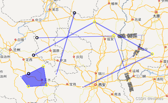
in other words , Just change the latitude and longitude and mark , You can achieve bln The effect of the document . Ovi can be loaded directly . This solves matlab 2012a Cannot output line segments as kml The problem of .
边栏推荐
猜你喜欢
iNFTnews | Web5 vs Web3:未来是一个过程,而不是目的地
Unity3D学习笔记6——GPU实例化(1)
GEE(四):计算两个变量(影像)之间的相关性并绘制散点图
JMeter-接口自动化测试读取用例,执行并结果回写
【编译原理】词法分析设计实现

Brush question 3
30讲 线性代数 第五讲 特征值与特征向量
十四、数据库的导出和导入的两种方法
![[microservices SCG] gateway integration Sentinel](/img/f3/410d7228b4b253ebf41015a785099f.png)
[microservices SCG] gateway integration Sentinel
Gee (IV): calculate the correlation between two variables (images) and draw a scatter diagram
随机推荐
Gee (III): calculate the correlation coefficient between two bands and the corresponding p value
Install a new version of idea. Double click it to open it
网络安全-burpsuit
USB(十四)2022-04-12
ROS2专题(03):ROS1和ROS2的区别【01】
微信论坛交流小程序系统毕业设计毕设(3)后台功能
Binary tree
树后台数据存储(採用webmethod)[通俗易懂]
Installing spss25
网络安全-联合查询注入
[microservices SCG] gateway integration Sentinel
Talk about the design and implementation logic of payment process
30讲 线性代数 第五讲 特征值与特征向量
2021ICPC上海 H.Life is a Game Kruskal重构树
智慧社區和智慧城市之間有什麼异同
位运算(Bit Operation)
FreeLink开源呼叫中心设计思想
Matlab 信号处理【问答随笔·2】
./ setup. Insufficient sh permission
Brush question 4