当前位置:网站首页>Arcgis\qgis no plug-in loading (no offset) mapbox HD image map
Arcgis\qgis no plug-in loading (no offset) mapbox HD image map
2022-07-05 21:04:00 【GIS thinking】
Just pay attention to us if you like !
Let's first introduce MapBOX.
Mapbox It is used for moving and Web Location data platform for applications . Users can use Mapbox Studio Create a custom 、 Interactive maps , Then you can apply these customized maps and data services to your website (Web) Or mobile apps (Mobile Web/Android/IOS) On .

In the previous article, we have introduced ArcGIS How to load various vectors of sky map without plug-ins 、 Satellite images, etc .
This time, we will introduce ArcGIS\QGIS No plug-in loading ( No offset )MapBox HD image and download .
One 、 Customize and share MapBox Map service
open Mapbox Official website .
https://www.mapbox.com/

2. If you don't have an account, you need to register an account for free , As shown in the figure above, click “Start mapping for free” Or in the upper right corner Get account Registered account .

register mapbox There is a thorny problem that you need , Verify your credit card . Of course, we are not willing to let him verify , So how can we solve it ?
We use a credit card virtual machine , Generate a series of virtual credit cards .
The following addresses of the available credit card virtual machines .
Address sensitive , I won't post him here , Look at the message area to get , Or backstage reply “ The credit card ” You can get the address .

Credit card generator - Random Encyclopedia  https://www.suijidaquan.com/credit-card-generator
3. After successful registration , You can automatically enter the following interface , Click Select “create a map in Studio”, Select... In the pop-up interface “New Style”.

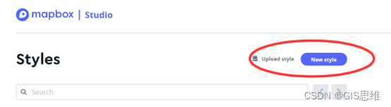
4. In the map category that pops up , choice Satellite Streets, Then click Select Customize Satellite Streets'

5. Automatically jump to MapBox Studiao Interface .

6. There will be a quick start guide for the first time , I've come in many times, but it's gone , You can learn by yourself . You can use the layers on the left 、 Change the configuration of various labels , For example, change English annotation to Chinese annotation , You can also change the font color , You can contact more about it .

7. After setting up , You can click... In the upper right corner “Share” Button , Share this Studio Application .

8. In the pop-up interface , choice “Third Party”, Copy the corresponding URl, The URL Can be added to ArcGIS and QGIS Used in the server of .

Two 、 ArcGIS load MapBOX Satellite pictures ( No offset )
stay ArcGIS A directory of GIS Double click... In the server “ add to WMTS service “

2. Adding WMTS Set the following parameters in the server of . The service address is copied above URL route .

3. load MapBox The satellite image is successful .

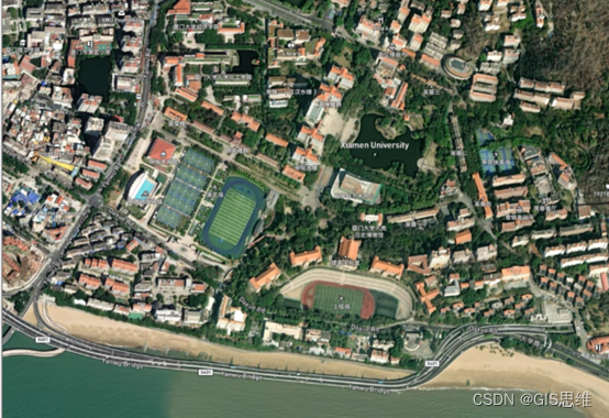
Xiamen University
6. The coordinate system of this kind of map is “WGS_1984_Web_Mercator_Auxiliary_Sphere”, And our country 2000 There is basically no offset . We loaded the non offset sky map vector loaded in the previous issue , Use the effects toolbar , It can be seen that there is basically no offset .

Four 、 QGIS add to MapBOX Satellite pictures ( No offset )
1. open QGIS, Select WMS/WMTS, The right choice “ New link ”

2. open QGIS, Select WMS/WMTS, The right choice “ New link ”, In the pop-up interface , Post the above mentioned URL Address .

3. Successful addition .

Welcome to Fujian
How to download these data ?
Follow our next tweet !
Recommend learning
ArcGIS Model builder for (ModelBuilder) Video tutorial
ArcGIS10.X Video tutorial for getting started (GIS thinking )
ArcGIS Remote sensing image classification and results application video course
ArcPy Combined with the batch drawing of data-driven module
ArcGIS And Data Reviewer Spatial data quality inspection
GIS thinking GIS Series of technical courses
边栏推荐
- 当用户登录,经常会有实时的下拉框,例如,输入邮箱,将会@qq.com,@163.com,@sohu.com
- Abnova maxpab mouse derived polyclonal antibody solution
- matplotlib绘图润色(如何形成高质量的图,例如设如何置字体等)
- Utils/index TS tool function
- 研學旅遊實踐教育的開展助力文旅產業發展
- Norgen AAV extractant box instructions (including features)
- How to send samples when applying for BS 476-7 display? Is it the same as the display??
- 显示屏DIN 4102-1 Class B1防火测试要求
- Prior knowledge of machine learning in probability theory (Part 1)
- Determine the best implementation of horizontal and vertical screens
猜你喜欢
Chemical properties and application instructions of prosci Lag3 antibody

研學旅遊實踐教育的開展助力文旅產業發展

请查收.NET MAUI 的最新学习资源
Using webassembly to operate excel on the browser side

How to make ERP inventory accounts of chemical enterprises more accurate

Clion-MinGW编译后的exe文件添加ico图标
CLion配置visual studio(msvc)和JOM多核编译

MySQL 千万数据量深分页优化, 拒绝线上故障!
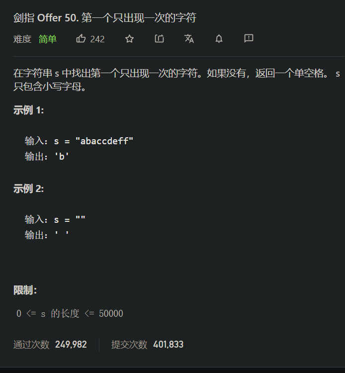
2.<tag-哈希表, 字符串>补充: 剑指 Offer 50. 第一个只出现一次的字符 dbc
Enclosed please find. Net Maui's latest learning resources
随机推荐
Add ICO icon to clion MinGW compiled EXE file
概率论机器学习的先验知识(上)
matplotlib绘图润色(如何形成高质量的图,例如设如何置字体等)
CLion配置visual studio(msvc)和JOM多核编译
Web Service简单入门示例
模式-“里氏替换原则”
Norgen AAV extractant box instructions (including features)
How to make ERP inventory accounts of chemical enterprises more accurate
Abnova maxpab mouse derived polyclonal antibody solution
Prosci LAG-3 recombinant protein specification
leetcode:1755. 最接近目标值的子序列和
LeetCode: Distinct Subsequences [115]
Binary search
XML modeling
Learning robots have no way to start? Let me show you the current hot research directions of robots
Phpstudy Xiaopi's MySQL Click to start and quickly flash back. It has been solved
Talk about my fate with some programming languages
Cutting edge technology for cultivating robot education creativity
wpf 获取datagrid 中指定行列的DataGridTemplateColumn中的控件
vant 源码解析之 utils/index.ts 工具函数