当前位置:网站首页>Behind the first lane level navigation in the industry
Behind the first lane level navigation in the industry
2020-11-06 20:07:00 【amap_tech】
Reading guide
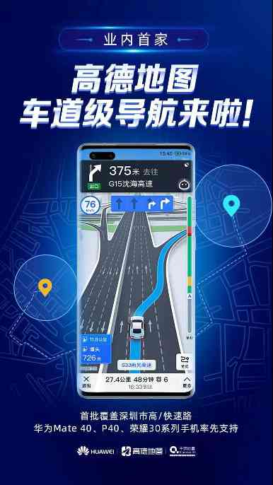
10 month 30 Japan , Huawei united with Gaode 、 Qianxun released the first lane level navigation application for mobile phone users in the industry . Behind this is the continuous development of high-precision positioning technology , Finally, it is the process of mature mass production . This paper will combine the work of gaude map in the field of lane level navigation and automatic driving , Share our thoughts on the evolution of high precision positioning technology , And some practices in the practical application of high precision positioning .
One 、 An overview of Golder positioning technology
Positioning technology is to support the navigation of Gaud map 、 Key basic technologies of core business such as transportation , His main task is to identify objects ( Usually people or cars ) Position and posture in a relatively fixed coordinate system . We use the mobile phone gaude map as an example to illustrate which technologies play a role in the actual application scenarios .
Generally, the basic positioning ability of mobile phone is determined by the mobile phone GNSS Chip provides , It provides us with... For most of the outdoor scenes 5~10 Meter positioning accuracy . But when the satellite signal is bad , Positioning may drift , We need to identify this situation . in addition , When the signal is disturbed , There may be a regular shift in position , We also need to identify interference , And if possible, find the right position again . When GNSS When it's not in place , Want to keep positioning , You can use sensors to recognize walking / Driving state , Then calculate the course (PDR、VDR). When you enter the room, the satellite signal is lost , The common positioning method is based on the base station scanned by the mobile phone and Wifi、 Bluetooth and other signals do network positioning .
These techniques provide the basic location coordinates , And in the navigation process , We are more concerned about which road we are driving on , There is no yaw , How far is it from the next intersection , To get this information, you need to use map matching technology . In some very complex situations , Such as viaduct 、 Main and auxiliary roads , It becomes very difficult to judge the path , At this time, we need to use some special recognition model to solve the matching problem .
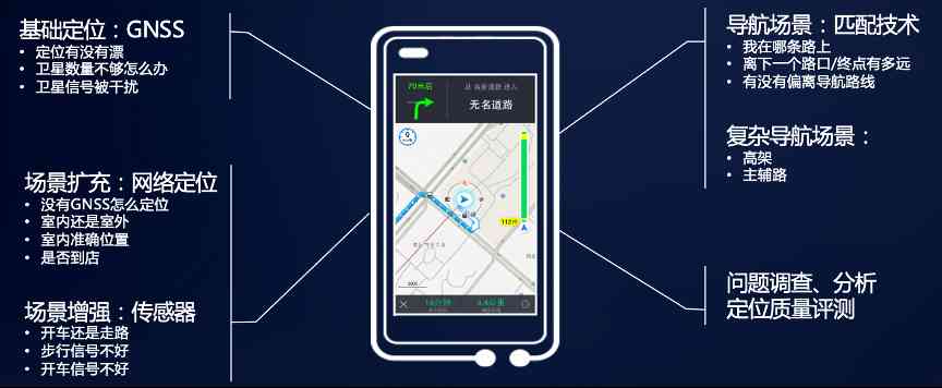
chart 1 Location technology in mobile phone Gaud map
The above is only part of the technology in a specific business scenario , Here's a more complete picture of Golder's positioning technology . In general , We're building a set of “ cloud + End + data ” The complete technical system of , And build a quality iteration system to ensure the continuous updating and iteration of each technical module , To support numerous positioning business applications .

chart 2 Big picture of Golder positioning technology
Two 、 How positioning technology evolves to high precision
Back to the picture 1, We can see that the location technology mentioned here extends the user scenario , But there is no obvious improvement in positioning accuracy . If you want to implement the lane level navigation mentioned above , Even more intelligent automatic driving , The positioning accuracy is required to be significantly improved to sub meter level , Even centimeter scale . So how to do this ? We will do an analysis from the perspective of technology .
First , Let's take a picture 2 Involved in the , And other, broader positioning technologies , According to the principle of positioning, it can be divided into three categories , They are dead reckoning 、 Geometric location and feature location . According to different positioning types, the factors affecting the accuracy are analyzed , Summarize the methods to improve the accuracy , Finally, we hope to find the technical path to achieve high-precision positioning .

surface 1 Analysis and summary of different positioning technologies
1. Dead reckoning
The basic principle of dead reckoning is to start from the position at the last moment , According to the direction of motion and distance to calculate the position of the next moment . Obviously, this positioning method requires a known starting position , Otherwise, we can only get the relative position change . At the same time, in the calculation process, the positioning error will continue to increase , So the direct factor affecting the accuracy is to calculate the time or distance .
Besides , The calculation accuracy is also affected by the measurement accuracy at each time , For inertial sensors , This is directly determined by the accuracy of inertial devices . for example , Strategic inertial navigation with the highest accuracy , The position error divergent with time can reach 30m/hr, by comparison , The precision of tactical inertial navigation is poor 3 An order of magnitude , And the consumer grade micromachines we use (MEMS) Inertial navigation accuracy is worse than tactical level 1~2 An order of magnitude .
In addition to device accuracy , The accuracy of the model in the calculation process will also affect the positioning accuracy , There are two aspects to this : One is the compensation model of the device measurement error , The second is the compensation model of calculation error . Usually only when the accuracy of the device itself is high enough , A more accurate compensation model needs to be considered .
2. Geometric positioning
Geometric positioning is to measure the range or angle of the reference equipment with known position , Then through geometric calculation to determine their own position . According to the way of geometric calculation , Include RSS( Signal strength )、TOA( Arrival time )、AOA( Arrival angle )、TDOA( Arrival time difference ) And so on . For angular positioning method , A small angle measurement error may produce a large position error in a distance from the positioning facility , So this method ( If AOA Method of Bluetooth location ) The positioning accuracy is usually limited by the range . In the ranging method , Using the time arrival model ( If TOA Methodical GNSS location , use TDOA Methodical UWB location ) Specific signal strength model ( If RSS Methods of Bluetooth and Wifi location ) More likely to achieve higher positioning accuracy . But in practice , The final positioning accuracy is affected by the accuracy of distance measurement , Especially in the scene of long-distance signal transmission such as satellite positioning , How to eliminate the measurement error in the signal propagation path , It becomes the key to determine the positioning accuracy . Besides , The accuracy of geometric positioning is also affected by the number and distribution of positioning facilities , The more facilities are observed at the same time 、 The more evenly distributed , The higher the accuracy is .
3. Feature location
The feature location method first obtains some features of the surrounding environment , Such as base station id、Wifi The fingerprint 、 Geomagnetic field 、 Images 、Lidar Point cloud, etc . There are two ways to deal with it , One is to match the received features with the feature maps collected in advance , Locate in the feature map ; The other is no feature map , Position and attitude estimation is carried out by comparing the feature changes of the front and back frames ( namely SLAM technology ), To achieve the relative positioning effect similar to dead reckoning . obviously , The direct factor affecting the accuracy of feature location is the number of features 、 Quality and discrimination .
therefore , Using signal fingerprint features ( Such as Wifi The fingerprint ) Because of the sparsity of the fingerprint, the accuracy of the method is usually limited . The location method based on environment perception features is in the case of intensive features ( Such as the number of high lines Lidar, Medium and high resolution images, etc ) It can achieve high precision , But in practical application, it is greatly affected by the environment , When the environmental characteristics are single ( Like the sky 、 snowy day ) The accuracy will be reduced, even unable to locate . in addition , The positioning accuracy of feature map matching method is also limited by the accuracy of feature map , Feature estimation method ( Like vision SLAM) The positioning error will accumulate with distance , It has a divergence effect similar to dead reckoning .
Combine the above analysis , It can screen out the technology selection with high precision positioning ability . The complete high precision positioning scheme requires at least one high precision absolute positioning technology , As in geometric positioning GNSS location , In feature location Lidar Point cloud matching, etc ; secondly , For the scenario constraints in these scenarios , Relative positioning means , Such as DR、SLAM Technology, etc. , To supplement .

surface 2 High precision positioning technology line
3、 ... and 、 High precision positioning of business scenarios and solutions
From the technical point of view, the possible implementation path of high-precision positioning is analyzed , Next, we will start from the specific business scenarios of Golder , Take a look at how these technologies are implemented in the actual business .
1. What kind of high-precision positioning capability is needed in actual business scenarios
Travel scene is the core business scene of goldmap . Take driving as an example , The traditional application is TBT(Turn-by-turn) Navigation is representative of road level applications , Its requirements for positioning accuracy are as follows 10m about . More sophisticated navigation experience , Such as lane level navigation , The car needs to be positioned in the driveway , This requires position accuracy to reach 1 Within meters . For smart driving scenarios , In order to ensure the safety of automatic driving of the machine , Higher requirements for positioning accuracy , Generally, the accuracy in the transverse direction of the road needs to be less than 20 centimeter .

chart 3 High precision application of driving travel scene
In addition to the requirement of accuracy , Different business scenarios also require other dimensions for high precision positioning capabilities .
1) reliability ( Or integrity ): This is mainly used to measure whether the positioning system has the ability to detect possible errors , This is particularly important for applications that rely on positioning for intelligent driving . such as , The system needs to give an accuracy radius for the current position , When the actual position accuracy is less than this radius , The system is reliable . therefore , For applications with high reliability requirements , The estimation of this radius is usually conservative .
2) Usability : If the system can accurately judge the current positioning accuracy to meet the navigation 、 Automatic driving and other business requirements , Then the system is available . obviously , Availability requires that the estimation of the accuracy radius should not be too large , Otherwise, the system will frequently think that positioning is unreliable , The related functions cannot be used .
3) Calculate the force : As an upgrade of traditional navigation applications , Lane level navigation is highly sensitive to computational power , Usually required to meet the current mobile phone 、 The computational power limitation of vehicle navigation . Intelligent driving is classified according to different degrees of intelligence (SAE Level1~Level5), The requirements for computational power are also different . Usually, the traditional vehicle electrical architecture of low-level intelligent driving can not provide more computing resources , The centralized computing unit used in high-level intelligent driving can provide more abundant computing resources .
In addition, there are many requirements related to practical application , For example, the time stability of the output positioning results , Locate the scope of the scene that can be covered .
To sum up , The core capability required for lane level navigation is to identify the current Lane , This generally requires positioning accuracy less than 1 rice , At the same time as a navigation application , It is necessary to improve the accuracy of road matching on the basis of traditional navigation . Low level intelligent driving (L3 following ) Lane recognition and road matching are required ( This is mainly to ensure that intelligent driving can only be opened within the permitted road range , Like the highway ) It's more accurate , Furthermore, it is required that the accuracy of the horizontal position should reach 20 centimeter , In addition, the reliability of the system is required to be higher .
The above two types of applications are our main business scenarios at present , Both of them require high precision positioning function under the condition of low computational power . To meet the needs of these businesses , We have developed a lightweight integrated positioning engine .
2. Lightweight integrated integration positioning solution
The positioning technology we use here mainly includes :RTK-GNSS technology , Image semantic matching ,IMU Or a car model DR Technology, etc. . among , Image semantic matching uses visual devices ( It's usually a smart camera on the car , Such as mobileye etc. ) Lane lines identified 、 Ground signs and other information as input , Matching and positioning with high-precision map data , This process deals with limited semantic elements , So it doesn't cost much . As for other technologies, they have been involved in traditional navigation and positioning , Therefore, the overall computational power consumption of the scheme can be controlled at the same level as the ordinary navigation .

chart 4 Integrated integration positioning solution
The above integrated scheme framework can receive all or part of the positioning signal input , At the same time, it provides the location results of road level and lane level , Ensure the continuity of positioning in the whole scene . When landing in a specific application , The form of the scheme is different .
For intelligent driving applications , High reliability requires more redundant information for fault tolerance , So it's usually necessary to RTK-GNSS、IMU、 Visual semantics and all the information input , After receiving this information, two problems need to be solved :1) How to judge which input signals are reliable ,2) How to make full use of all information for fusion positioning .
Here we use particle filter based on multi hypothesis as the basic algorithm of high precision fusion location , And the design and implementation of the following algorithm improvement :
-
Reduce the particle dimension according to the assumed characteristics , Reduce computation ;
-
Hierarchical normalization is used to solve the problem of particle degradation caused by small system errors ;
-
Context based posterior confidence calculation , Solve the missing or wrong confidence level of input signal ;
-
Input signal delay and out of sequence processing based on signal window ;
-
Using high-precision satellite positioning and high-precision map data to assist sensor calibration , promote DR Ability .
At present, the algorithm has been used in a L3 Level intelligent driving vehicle landing , Large scale experiments are being carried out .
For lane level navigation applications , Due to the limitation of cost and usage conditions , It's usually not possible to get all the input information . But according to the table 2, We need at least RTK-GNSS Or one of the visual semantics for high-precision absolute positioning . On the mobile terminal , The more convenient solution is to upgrade the mobile phone GNSS Chip support RTK Difference to improve accuracy . The first lane level navigation application on Huawei mobile phone is to integrate Huawei and Qianqian search technology and services to achieve high-precision absolute positioning .
For the car machine , Intelligent camera information used in low-level intelligent driving function can be connected to navigation , Direct upgrade of lane level navigation function . The high precision fusion location in this application scenario is still based on the above particle filter algorithm , But it is necessary to adapt various input signal types and signal characteristics flexibly in algorithm and engineering .
in addition , According to the characteristics of the navigation scene , The integrated fusion positioning is also based on the lane level positioning results , Like whether the car is on the exit lane , To help judge the main and auxiliary roads 、 Yaw under complex road conditions such as viaduct , Enhance the overall experience of user navigation .
At present, the lane level navigation based on Huawei mobile phone will be released online , The vehicle lane level project is also being implemented , I'll see you soon .
3. Multiple tight coupling for complex scenes SLAM technology
The above lightweight fusion positioning scheme can solve most of the outdoor occlusion 、 The problem of high-precision location of semantic clear scene , But for more complex scenarios , Like indoors 、 The parking lot 、 City complex intersection and so on , High precision GNSS May not be valid , Visual semantic information is also less , At this time, we need to integrate more abundant positioning means . At a high level of intelligent driving (L4 above ) In common use Lidar Point cloud matching , and / Or high precision inertial navigation DR To ensure continuous high-precision positioning , but Lidar And high precision inertial navigation costs a lot , Large scale applications are limited .SLAM Technology can use low-cost visual sensors , Continue to calculate high-precision position and attitude , It can be used as an effective means of low-cost and high-precision positioning . Compared to the lightweight scheme above , It's computationally expensive , But in the current environment of continuous upgrading of terminal computing power , Still has good landing potential .
Our idea is to use a tightly coupled scheme , Make the best use of all kinds of low-cost sensors :GNSS、IMU、 Information provided by vision, etc , According to the error characteristics of these information in different dimensions , Build an optimization model , To achieve the optimal position and attitude estimation .

chart 5 Multivariate tight coupling SLAM Algorithm framework
We're making datasets public EuRoc and Kaist This set of tight coupling is compared on SLAM Algorithms and the current popular vision -IMU Fusion algorithm 、 Vision -IMU-GNSS The effect of fusion algorithm , Its position accuracy is improved 1 More than times . Next we'll be on the cell phone 、 The computational power consumption of the optimization algorithm on the vehicle terminal , And in the future, high-precision navigation for all scenes 、 Intelligent driving application landing .
Four 、 Summary and prospect
Positioning technology has a long history . in fact , If we go back 20 or 30 years ago or even earlier , At that time, a professional high-precision positioning technology for surveying and mapping was produced , So positioning accuracy itself is not a problem . But today, we should improve the precise positioning under the background of profound changes in people's travel modes , The problem we're facing is how to build affordable users , Technology and application that can really provide convenience for travel .
therefore , In the future, high-precision positioning needs to expand the scene application first , From outside to inside , From driving to walking , Finally, the whole scene coverage is achieved . According to the characteristics of scene application , Clear positioning for high precision in the accuracy of 、 reliability 、 Cost and other dimensions of demand . Fully integrated with the current rapid development of sensing 、 Communications 、 Computing and other fields of Technology , Design the best solution . Possible research and development directions include :
-
Low cost, high precision GNSS technology , Such as PPP-RTK Technology, etc. ;
-
Based on the latest communication technology ( Such as 5G) High precision positioning ;
-
Based on the latest perception technology ( Low cost Lidar) High precision positioning ;
-
Deeper integration of various positioning technologies ( Such as IMU、 Visual aids RTK Solution ).

版权声明
本文为[amap_tech]所创,转载请带上原文链接,感谢
边栏推荐
- C語言I部落格作業03
- Introduction to quantitative investment and Trading (Python introduction to financial analysis)
- keras model.compile Loss function and optimizer
- Elasticsearch数据库 | Elasticsearch-7.5.0应用搭建实战
- Interface pressure test: installation, use and instruction of siege pressure test
- React design pattern: in depth understanding of react & Redux principle
- It's easy to operate. ThreadLocal can also be used as a cache
- Recommendation system based on deep learning
- Jetcache buried some of the operation, you can't accept it
- Humor: hacker programming is actually similar to machine learning!
猜你喜欢
Named entity recognition in natural language processing: tanford core LP ner (1)

Introduction to the structure of PDF417 bar code system
Word segmentation, naming subject recognition, part of speech and grammatical analysis in natural language processing

一篇文章带你了解CSS3圆角知识

一部完整的游戏,需要制作哪些音乐?
NLP model Bert: from introduction to mastery (2)

事件监听问题

It's easy to operate. ThreadLocal can also be used as a cache

【自学unity2d传奇游戏开发】如何让角色动起来
Python download module to accelerate the implementation of recording
随机推荐
A course on word embedding
Analysis of partial source codes of qthread
Introduction to the structure of PDF417 bar code system
给字节的学姐讲如何准备“系统设计面试”
Unity性能优化整理
MeterSphere开发者手册
How to hide part of barcode text in barcode generation software
NLP model Bert: from introduction to mastery (2)
Jmeter——ForEach Controller&Loop Controller
How to use Python 2.7 after installing anaconda3?
事件监听问题
Solve the problem of database insert data garbled in PL / SQL developer
What is the difference between data scientists and machine learning engineers? - kdnuggets
这个项目可以让你在几分钟快速了解某个编程语言
Mongodb (from 0 to 1), 11 days mongodb primary to intermediate advanced secret
NLP model Bert: from introduction to mastery (1)
Elasticsearch数据库 | Elasticsearch-7.5.0应用搭建实战
Pattern matching: The gestalt approach一种序列的文本相似度方法
With the advent of tensorflow 2.0, can pytoch still shake the status of big brother?
使用 Iceberg on Kubernetes 打造新一代雲原生資料湖